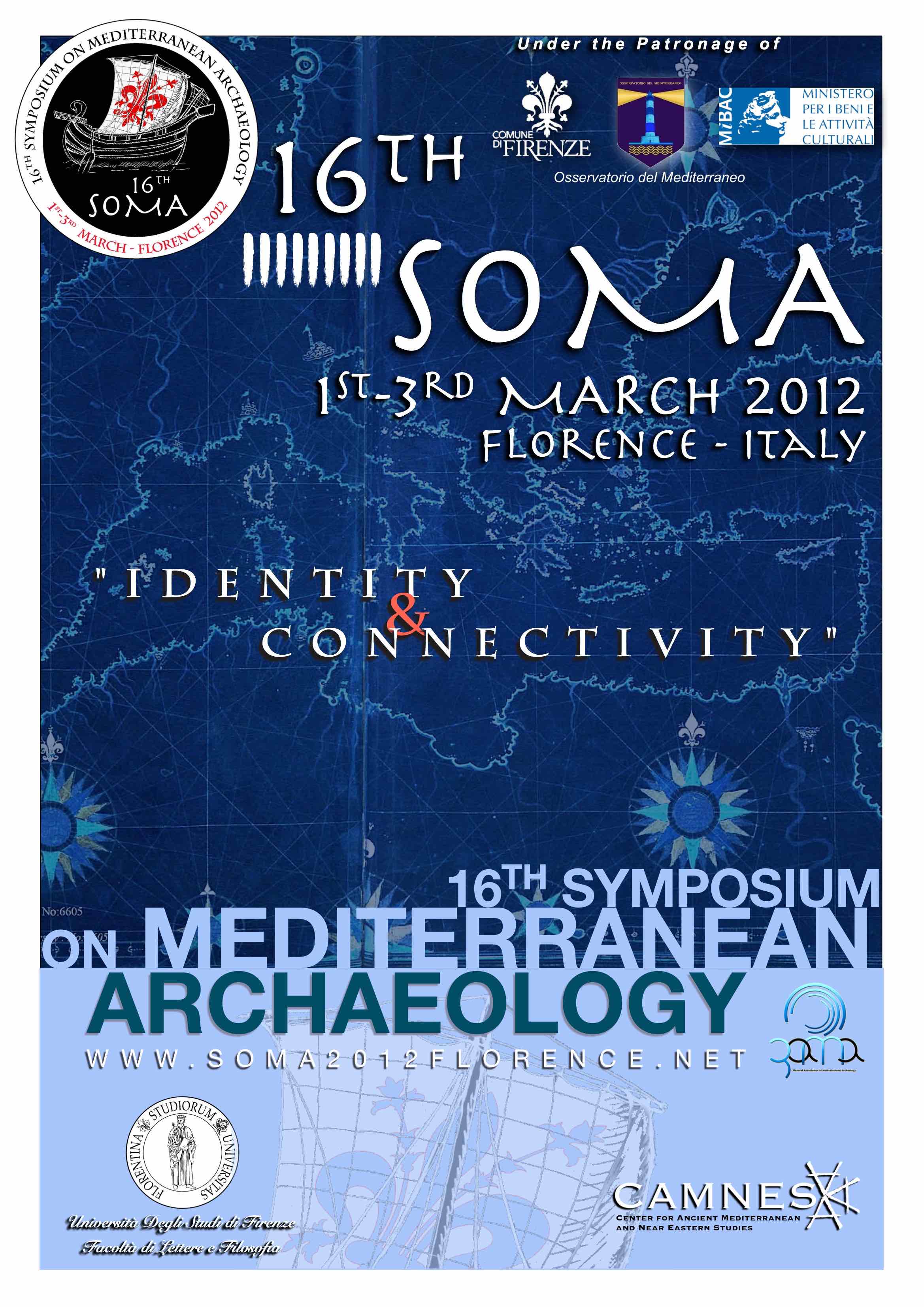
16° SOMA - Symposium on Mediterranean Archaeology
1 - 3 March 2012 Florence, Italy
"IDENTITY & CONNECTIVITY"
The 16° SOMA is under the patronage of Comune di Firenze, Ministero per i Beni e le Attività Culturali, Osservatorio Mediterraneo and GAMA


ORGANIZING INSTITUTIONS

Università di Firenze - Facoltà di Lettere e Filosofia, Dipartimento SAMeRL (Scienze dell’Antichità, Medioevo, Rinascimento e Linguistica)
Piazza Brunelleschi 4, 50121 - Firenze, Italy
www.lettere.unifi.it

CAMNES - Center for Ancient Mediterranean and Near Eastern Studies
Via del Giglio 15, 50123 - Firenze, Italy
www.camnes.org

General Association of Mediterranean Archaeology
www.genama.info
SCIENTIFIC COMMITTEE
Prof. Giovannangelo Camporeale (University of Florence & CAMNES)
Prof. Anna Margherita Jasink (University of Florence)
Prof. Paolo Liverani (University of Florence)
Prof. Fabio Martini (University of Florence)
Prof. Stefania Mazzoni (University of Florence & CAMNES)
Prof. Guido Vannini (University of Florence)
Dr. Massimo Cultraro (National Research Council, CNR & CAMNES)
Dr. Nicola Laneri (University of Catania & CAMNES)
Assist. Prof. Ertekin Doksanaltı (GAMA - Selçuk University)
Dr. Lihi Habas (Hebrew University of Jerusalem)
Prof. Alexandr Okorokov (Russian Academy of Sciences)
Prof. Ahmet Adil Tırpan (Selçuk University)
ORGANIZATION COMMITTEE
Dr. Luca Bombardieri (University of Florence)
Dr. Anacleto D’Agostino (University of Florence)
Guido Guarducci – PhD Candidate (CAMNES, University of Reading)
Dr. Valentina Orsi (University of Florence)
Dr. Stefano Valentini (CAMNES)
SECRETARY
Dr. Francesca Amato
info@soma2012florence.net
www.soma2012florence.net
SYMPOSIUM PROGRAM SCHEDULE
|
THURSDAY MARCH 1ST 2012 |
|
|
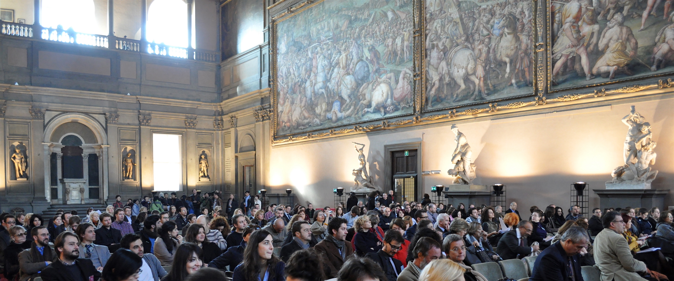
Palazzo Vecchio, Salone dei Cinquecento Piazza della Signoria 10.30 a.m. - PLENARY OPENING SESSION Welcome Addresses by the Civil and Academic Authorities KEYNOTE LECTURE A.B. KNAPP - Materiality, Identity and Connectivity in the Prehistoric Mediterranean |
|
|
1.00-2.00 p.m. |
LUNCH BREAK |
|
THURSDAY MARCH 1ST 2012 |
||||||
|
SESSION 1 |
||||||
|
UniFi – P.zza Brunelleschi AULA MAGNA |
UniFi – P.zza Brunelleschi SALA COMPARETTI |
UniFi – P.zza Brunelleschi AULA APOLLO |
UniFi – P.zza Brunelleschi AULA EMICICLO |
CAMNES – Via Faenza AULA MAGNA |
||
|
Levant, Egypt and the Eastern Mediterranean (I) CHAIR: Fabrizio Venturi |
Eastern Mediterranean and Aegean (EBA-MBA) CHAIR: Frances Pinnock |
Ancient Egypt (I) CHAIR: Maria Cristina Guidotti |
The Aegean and Western Anatolian coast during the Archaic period |
Tyrrenian Interactions (LBA-IA) CHAIR: Luigi Donati |
||
|
2.00-4.00 p.m. |
2.00 2.20 |
Aaron Burke Excavating Egypt in Jaffa: The Jaffa Cultural Heritage Project, Progress Report 2011 |
Angelo Colonna The Unification of Ancient Egypt: founding a state, creating an ideology, establishing an identity |
Nicola Ialongo Nuragic Sardinia in the Western Mediterranean historical frame between the end of the Bronze Age and the Early Iron Age (1000-750 B.C.): a new chronological perspective |
||
|
2.20 2.40 |
Lukasz Niesiolowski- Spanò |
Alfredo Carannante Shell Ornaments Distributional Patterns in Aegean and Eastern Mediterranean Bronze Age as Indicators of Identity and Connectivity |
Özel Teraman Çınar Different Cultures Similar Intentions: Ideas of Divine Rule within the Cultural Framework of the Mesopotamian and Egyptian Civilizations |
Liena Kukoba Written and archaeological evidence about Delos of the Archaic period: the problem of correlation |
Marine Lechenault Northern Corsica and Etruria (IX- VIIIth c. BC). Archaeological evidences of Transtyrrhenian evolutions at the beginning of Iron Age |
|
|
2.40 3.00 |
Eric Jensen Sea Peoples and Syria: New Evidence of Cultural Interaction at Tell Qarqur |
Andrea Polcaro The Stone and the Landscape: the phenomenon of megalithic constructions in Jordan in the main historical context of Southern Levant at the beginning of the 3rd Millennium BC |
Joanna Popielska- Grzybowska |
Alexandra Kasseri Transport amphorae from Methone in Pieria, Greece. Preliminary results on trade in the Northern Aegean during the Archaic period |
Kewin Peche-Quilichini, Eliana Piccardi |
|
|
3.00 3.20 |
Yosef Garfinkel Archaeology of King David: State Formation and Urban Planning in Biblical Judah |
Marta D'Andrea Of Pots and Weapons: Constructing the Identities during the Late 3rd millennium BC in the Southern Levant |
Ilaria Incordino The 'Strong of voice' and 'Desert Governor' titles during the IIIrd Egyptian Dynasty |
Kenan Eren Heraion of Samos and Artemision of Ephesos in the Archaic Period: A Comparison |
Gabriele Carenti, Antonella Unali |
|
|
3.20 3.40 |
Avraham Faust The Southern Levant in the Late Iron Age: Between the International Maritime Trade and the Mesopotamian Powers |
Angela Massafra Interconnections between Palestine and Egypt in the early 2nd millennium BC: a view from Jericho |
Massimiliano Franci Being a stranger in Egypt, between maintenance and loss of cultural identity: The Archaeological Data |
Muna Silav, Seviç Bahar Yenigul |
Cristina Nervi Living in Nora (CA-South Sardinia): melting pot of cultures |
|
|
3.40 4.00 |
Discussion |
|||||
|
4.00-4.20 p.m. |
COFFEE BREAK |
|||||
|
SESSION 2 |
||||||
|
UniFi – P.zza Brunelleschi AULA MAGNA |
UniFi – P.zza Brunelleschi SALA COMPARETTI |
UniFi – P.zza Brunelleschi AULA APOLLO |
UniFi – P.zza Brunelleschi AULA EMICICLO |
CAMNES – Via Faenza AULA MAGNA |
||
|
Levant, Egypt and the Eastern Mediterranean (II) CHAIR: Philippe Quenet |
Cypriot Pre- and Protohistory |
Ancient Egypt (II) CHAIR: Gloria Rosati |
Interactions within the ancient Greek world CHAIR: Anna Anguissola |
Etruscan Identities CHAIR: Pierluigi Giroldini |
||
|
4.20-6.00 p.m. |
4.20 4.40 |
Ada Nifosi Childbirth practices and beliefs in ancient Egyptian and ancient Near Eastern sources, in the Talmud and in the Bible: a comparative study based on a selection of texts and material artefacts |
Constantinos Constantinou |
R. Gareth Roberts Which came first, the chicken or the egg? And what on Earth does this have to do with identity and connectivity in Mediterranean archaeology? |
Konstantina Chavela Archaic local painted pottery from Central Macedonia. The case of Thermaic Gulf |
Federica Gonzato Contacts, innovation and social creativity: interactions between Aegean and North-Eastern Italy |
|
4.40 5.00 |
Dalit Regev Egyptian Stone Objects from Tel Miqne-Ekron – Canaanite- Phoenician Trade in Egyptian Cult- Objects and their Mediterranean Distribution |
Dimitrios Kloukinas, Ioannis Voskos |
Bettina Bader Identity visible in material remains in an ancient Egyptian settlement of the late Middle Kingdom |
Kamila Nocoń |
Muzaffer Demir Lydian (Anatolian) Origins of Etruscans: A Reconsideration |
|
|
5.00 5.20 |
Gunnar Lehmann Greek Mercenaries of the 26th Dynasty of Egypt in the Levant |
Yiannis Violaris, Luca Bombardieri, Caterina Scirè Calabrisotto, Mariaelena Fedi, Lucia Caforio The Bronze Age cemetery at Lofou- Koulauzou (Cyprus): towards a cross-analysis of radiocarbon results and funerary assemblages within the burial contexts. |
Philipp Quenet, G. Pierrat, M. Casanova, V. Danrey, S. Donnat, D. Lacambre |
Filippo Giudice, Rossano Scicolone, Sebastiano Luca Tata |
Alberto Agresti Population strategies and cultural phenomena in north and central Tuscany from Late Bronze Age to Early Iron Age: continuity and change. Landscape analysis and cultural data |
|
|
5.20 5.40 |
Dagmara Wielgosz Marble for Phoenician Purple. Classical Sculptures on the Levantine Coast |
Francesca Chelazzi, Marialucia Amadio |
Beth Ann Judas 'Mingle with the Courtiers': The Concept of the Keftiu as the "Good" Foreigner in New Kingdom Egypt |
Nihal Tuner Onen Ideas about the historical identity and connections of the city of Phaselis as an Eastern Mediterranean port |
Stefano Giuntoli The Etruscan necropolis of Macchia della Riserva/Pian delle Rusciare at Tuscania: a preliminary report |
|
|
5.40 6.00 |
Discussion |
Silvia Nencetti Accesa-Macchia del Monte Excavation Project: new data from Area E |
||||
|
6.00 6.20 |
Discussion |
|||||
|
THURSDAY MARCH 1ST 2012 |
|
Museo Archeologico Nazionale Piazza SS. Annunziata, 9 7.00 p.m. - WELCOME RECEPTION Special Evening Opening for Participants |
|
FRIDAY MARCH 2ND 2012 |
||||||
|
SESSION 3 |
||||||
|
UniFi – P.zza Brunelleschi AULA MAGNA |
UniFi – P.zza Brunelleschi SALA COMPARETTI |
UniFi – P.zza Brunelleschi AULA APOLLO |
UniFi – P.zza Brunelleschi AULA EMICICLO |
CAMNES – Via Faenza AULA MAGNA |
||
|
Levant and Eastern Mediterranean during the Iron Age |
Ugarit and the Eastern Mediterranean (LBA-IA) CHAIR: Stefania Mazzoni |
Egypt: Persian and Hellenistic Ages CHAIR: Joanna Popielska- Grzybowska |
Between Black Sea and Aegean CHAIR: Emma Maglio |
Italian Peninsula Before the Romans CHAIR: Alessandro Maccari |
||
|
8.40-10.20 a.m. |
8.40 9.00 |
Frank Hardisty Geographic Visualization of Archeological Sites: a Cisjordanian Example |
Anna Lanaro Late Bronze Age Iconographic Interconnections: Reflections on the "Nursing Goddess from Ugarit“ |
Alessio Corsi The songstress Diesehebsed in the chapel of Osiris-Onnophris in the Persea Tree in Karnak |
Daniş Baykan |
Pierluigi Giroldini Hilares pagi: settlement organization of the Plain of Piombino (Livorno, Italy) in ancient times |
|
9.00 9.20 |
Christine Thompson The ‘Architecture’ of the Cisjordan Corpus and its Western Mediterranean context |
Erika Fischer Niqmaddu of Ugarit and his consort – a reassessment of the so-called Marriage Vase |
Květa Smoláriková |
Ilkan Hasdağlı |
||
|
9.20 9.40 |
Maria Gabriella Micale Inquiring into diversity. The Persian Clay Figurines in Syria |
Valérie Matoïan Material Culture and Identity in the Kingdom of Ugarit: Images of Egyptian Deities |
Ilaria Cariddi ‘God loves the silent one’: the value of silence in ancient Egypt through temple interdicts and autobiographical inscriptions |
Maria Girtzi Aspects of Pre-Roman History, Organization, Religion & Trading Contacts of "Second Generation" Greek Colonies of the Western littoral of Black Sea: the case of Anchialos, Bizone, Nikonio and Tomoi |
Maria Clara Martinelli, Tania Quero |
|
|
9.40 10.00 |
Gabriele Carenti, Giuseppe Minunno |
Riccardo Besana Textile developments and interconnections between the Eastern Mediterranean, Anatolia and the Levant from the End of the II and the Middle of the I Millennium BC |
Gabriella Carpentiero, Emanuele Mariotti |
Maria Girtzi, Athanasia Bountidou |
Carmelo Colelli, Amedeo Fera |
|
|
10.00 10.20 |
Discussion |
|||||
|
10.20-10.40 a.m. |
COFFEE BREAK |
|||||
|
SESSION 4 |
||||||
|
UniFi – P.zza Brunelleschi AULA MAGNA |
UniFi – P.zza Brunelleschi SALA COMPARETTI |
UniFi – P.zza Brunelleschi AULA APOLLO |
UniFi – P.zza Brunelleschi AULA EMICICLO |
CAMNES – Via Faenza AULA MAGNA |
||
|
The Iron Age Micro- Archaeology in Israel: Some Broader Mediterranean Implications (Workshop) CHAIR: Israel Finkelstein |
Eastern Mediterranean and Aegean (LBA) CHAIR: A. Bernarnd Knapp |
Egypt and Levant: Ptolemaic and Roman Ages CHAIR: Bettina Bader |
Between Greece and Western Anatolia: the Hellenistic and Roman periods (I) CHAIR: Roberto Perna |
Central and Southern Italy: Indigenous and Greek Identities CHAIR: Carmelo Colelli |
||
|
10.40-1.00 p.m. |
10.40 11.00 |
Israel Finkelstein The Iron Age Archaeology and Exact and Life Sciences Project and its Mediterranean Aspects |
Giampaolo Graziadio The importance of mouth coverings in the Late Cypriot funerary customs |
Giorgia Cafici Ptolemaic sculpture between Egypt and Rome: the statue of Hor son of Hor |
Caterina Parigi The Romanization of Athens: Greek identity and connectivity between Athens and Rome in the I century B.C. |
Orlando Cerasuolo Suction Vases with Tubular Rim in Eastern Mediterranean and Central Italy |
|
11.00 11.20 |
Steve Weiner, Dvory Namdar, Aren Maeir, Alexander Zukerman, Dan Cabanes, Ruth Shahack- Gross A Microarchaeological Analysis of a 9th Century Destruction Layer at Tell es-Safi/Gath |
Pantelis Komninos Ethnic Landscapes and Collective Identity in the Aegean Late Bronze Age |
Rafał Czerner with Grażyna Bąkowska- Czerner |
Michele Scalici “The Crossing”. Identity and connettivity in The Upper Ofanto Valley |
||
|
11.20 11.40 |
Alexander Fantalkin Mediterranean Iron Age Chronology – The Problem |
Marcus Bajema The lapis lazuli road: a view from the Mycenaean ‘periphery’ |
Krzysztof Jakubiak Tell Farama (Pelusium). The city on Sinai - where Egypt and Middle East meets. |
Asuman Laetzer-Lasar Cultural Identity in Transition - the Case of Late-Hellenistic Ephesos |
Signe Barfoed Miniature pottery as evidence for connectivity in religious practices between mainland Greece, the colonies and the indigenous Messapian community from the 7th-4th centuries BC. |
|
|
11.40 12.00 |
Elisabetta Boaretto Radiocarbon Dating and Synchronization of Iron Age Chronologies in the Eastern Mediterranean: Resolution and Solution |
Katrin Bernhardt Mycenaean imports to Crete and the Levant: Some thoughts on the interrelations |
Adriana de Miranda Historical water constructions in the Mediterranean |
Anna Anguissola, Leonardo Bochicchio, Antonio Calabrò, Silvana Costa |
Sine Saxkjær The Lost Indigenous People: The Question of an Indigenous Ethnic Identity in a World of Greek Material at the Timpone della Motta |
|
|
12.00 12.20 |
Ayelet Gilboa, Dvory Namdar |
Barbara Montecchi Prothesis and deposition scenes between Crete and Mainland Greece in Late Minoan/Helladic III Period |
Dincer Savas Lenger The “Egyptians’ Country” In Asia Minor and the Coins Bearing the Legend ΘY |
Vedat Keleş, Ersin Çelikbaş Spacer tubes from Parion slope building |
Adriano Orsingher The Hellenisation of the Punic world: a view from the Tophet |
|
|
12.20 12.40 |
Barak Sober Multispectral Imaging as a Tool to Enhance Reading of Ostraca |
Flavia Carraro Writing and book-keeping in Ancient Mycenaean Linear B Script: Technology and Texts between Archaeology and Philology |
Emanuele Casagrande Cicci |
Iulian Moga Connectivity and Reactivity. Pagans, Jews, and Christians in Roman Imperial Sardis |
Gerald Finkielsztejn, Gloria Olcese |
|
|
12.40 1.00 |
Discussion |
|||||
|
1.00-2.00 p.m. |
LUNCH BREAK |
|||||
|
SESSION 5 |
||||||
|
UniFi – P.zza Brunelleschi AULA MAGNA |
UniFi – P.zza Brunelleschi SALA COMPARETTI |
UniFi – P.zza Brunelleschi AULA APOLLO |
UniFi – P.zza Brunelleschi AULA EMICICLO |
CAMNES – Via Faenza AULA MAGNA |
||
|
Assyrians and the Eastern Mediterranean CHAIR: Francesca Baffi Guardata |
Western Anatolia and the Aegean CHAIR: Anna Margherita Jasink |
Hellenistic and Roman Cilicia CHAIR: Gabriella Carpentiero |
Between Greece and Western Anatolia: the Hellenstic and Roman periods (II) CHAIR: Paolo Liverani |
Magna Graecia CHAIR: Benedetto Carroccio |
||
|
2.00-3.30 p.m. |
2.00 2.20 |
Andrew Jamieson Processes of Assyrianisation: identity and connectivity manifested in Neo- Assyrian ceramics and the Tell Ahmar Area C pottery |
Veli Ünsal Relations between Anatolia and Greece (2nd and 1st Mill. B.C.) |
Füsun Tülek Terracotta finds of the Deli Halil ancient settlement: Architectural tiles and anthropomorphic pieces |
Esen Ogus Complexities of Greek Identity in Asia Minor: The Case of Sarcophagi from Aphrodisias |
Ambra Pace Material culture and identity. Stylistic models and figurative languages in the coroplastic production of Eastern Sicily in the archaic period |
|
2.20 2.40 |
Dirk Wicke From the Levant to Iran - Iron Age frit seals and Assyria |
Çiğdem Maner |
Emel Erten Olba in Eastern rough Cilicia: processes of Hellenization and Romanization in an Eastern Mediterranean town |
Elisa Bazzechi Athenian Identity In Late Antiquity |
Rossana Scavone Greek's food and other's food: the role of the diet in the construction of the social identity. Archeozoology of a greek colony and a native settlement within its inland |
|
|
2.40 3.00 |
Silvana Di Paolo From Cesnola onwards. Theorizing Cultural Interaction Between Cyprus and Assyria. Historical and Methodological Overview |
Konstantinos Giannakos Aegean type Swords and Finds in Anatolia, Technology of Metals and Structures, Written Sources and the dating of Trojan War |
Veronica Iacomi Local and foreign identities in funerary contexts: self- and social representation of indigenous élites in late Hellenistic and Roman Rough Cilicia. Rock-cut tombs and necropolis, a preliminary survey |
Hüseyin Köker A New Bronze Coin Type of Ariassos |
Mariagrazia Finistrella Distribution of Attic figured vases’ shapes in Sicily between 475 BC and the fourth century BC: the frame of reference |
|
|
3.00 3.20 |
Krzysztof Ulanowski The Mutual Relation of Assyrian, Phoenician, Greek and Egyptians Gods and Heroes on Cyprus in the Geometric and Archaic Periods |
Abuzer Kızıl Ancient remains at Beçin in Caria |
Mehmet Tekocak Late Roman Amphorae In Kelenderis |
Manuel Parada López de Corselas |
Marianna Spinelli The “SOMA” of the god: subtypes as qualification of the corporal gestures of the main subject of the coins of Kaulonia |
|
|
3.20 3.30 |
Discussion |
|||||
|
3.30-3.50 p.m. |
COFFEE BREAK |
|||||
|
SESSION 6 |
||||||
|
UniFi – P.zza Brunelleschi AULA MAGNA |
UniFi – P.zza Brunelleschi SALA COMPARETTI |
UniFi – P.zza Brunelleschi AULA APOLLO |
UniFi – P.zza Brunelleschi AULA EMICICLO |
CAMNES – Via Faenza AULA MAGNA |
||
|
Iron Age Anatolia CHAIR: Çiğdem Maner |
Bronze Age Crete (I) CHAIR: Judith Weingarten |
Hellenistic and Roman Eastern Mediterranean CHAIR: Hulusi Gulec |
Central and South-Eastern Europe during the Roman period |
Southern Italy Coinages CHAIR: Francesco Petrini |
||
|
3.50-5.00 p.m. |
3.50 4.10 |
Geoffrey Summers Crushed Between Empires: Destruction and Death at Kerkenes, an Iron Age Capital in Central Turkey |
Christina Papoulia, Eleni Chriazomenou |
Erkan Iznik Monumental Tomb in Side, Antalya, Turkey (Can a tomb be an example for the transformation of an empire and a new wealthy class in ancient Side?) |
Bozena Jozefow- Czerwinska |
Benedetto Carroccio The changeable and analogous SOMA of the identitary river-gods in Greek Coinages |
|
4.10 4.30 |
Baptiste Vergnaud A Phrygian identity in fortification? |
Alessandro Sanavia New data on the Impressed Ware and Creamy-White Coated Ware from Middle Minoan Phaistos (Crete) |
Andrea Gennaro, Ghiselda Pennisi |
Barbora Weissova Spatial Analysis of Burial Mounds in Bulgaria |
Viviana Lo Monaco The Syracusan small golden coins of the late V century B.C. |
|
|
4.30 4.50 |
Atilla Batmaz A Lion-Headed Shield from Ayanis: An identifier of the Urartian Culture? |
Roberta Rio New Light on Phaistos Disc. The rediscovery of an ancient ritual |
Simona Candia Water cult and sanctuaries of sources in the Hellenistic – Roman period |
Juan Manuel Bermúdez Lorenzo |
Maria Agata Vicari Sottosanti |
|
|
4.50 5.00 |
Discussion |
|||||
Università degli Studi di Firenze – Aula Magna del Rettorato
Piazza S. Marco, 4
5.30-6.30 p.m. - LECTURE
I. FINKELSTEIN - Megiddo Highlights: After 20 Years in the Field
|
SATURDAY MARCH 3RD 2012 |
||||||
|
SESSION 7 |
||||||
|
UniFi – Via Laura AULA 12 |
UniFi – Via Laura AULA 9 |
UniFi – Via Laura LABORATORIO 2 |
UniFi – Via Laura AULA 7 |
CAMNES – Via Faenza AULA MAGNA |
||
|
Anatolia Between the Early and Late Bronze Age CHAIR: Geoffrey Summers |
Bronze Age Crete (II) CHAIR: Eleonora Pappalardo |
Roman North Africa CHAIR: Elizabeth Robinson |
Anatolian and the Black Sea during the Byzantine period |
Central Mediterranean in the Hellenistic and Roman periods (I) |
||
|
8.20-10.20 a.m. |
8.20 8.40 |
Murat Türkteki The First Use and Distribution of Wheelmade Pottery in Western and Central Anatolia |
Ilaria Caloi Connecting Crete with the Near East and the Egypt in the Minoan Protopalatial period: what news in the 21st century? |
Giuseppe Mazzilli Originality and identity of the first imperial age architecture of Lepcis Magna: the Arch of Trajan |
Oleksandr Farbey An Identification of Sudak Fortress (Crimean Peninsula) in the light of the history of the Byzantine and Italian influence in the Black Sea region |
Jane Hjarl Petersen Identity negotiations and Code- switching in funerary contexts – how do we successfully apply theory to the study of burial archaeology? |
|
8.40 9.00 |
Özlem Tütüncüler Bircan Swastika: A Symbol Known to be of Indo-European-origin in the Early Bronze Age Anatolia |
Judith Weingarten The Arrival of Egyptian Taweret and Bes[et] on Minoan Crete: Contact and Choice |
Monika Rekowska- Ruszkowska |
Ayşe Türker |
Maja Mise Maritime Trade between the two Adriatic Coasts in Early Hellenistic Period |
|
|
9.00 9.20 |
Filiz Divarcı Early Bronze age human settlement in Marmara region |
Jakub Žežule “Minoan Zeus” as a link between the Bronze Age and the Iron Age |
Federico Marri Interregional trade in Roman Morocco: the study of Terra Sigillata at Thamusida (Sidi Ali Ben Ahmed) as a social and economic link tracer |
Ayşe F. Erol |
Roberto Perna Hadrianopolis (Sofratikë, Albania): monumental and economic evolution |
|
|
9.20 9.40 |
Neyir Kolankaya-Bostancı The Decline of Chipped Stone Industry during the Second Millennium B.C: Evidence from Panaztepe |
Nikos Stampolidis, Joan Aruz |
Josephine Shaya Bury Me Not on Foreign Shores: Roman North Africans, Death and Travel |
Luigi Oliva, Güven Gümgüm |
Nicola Chiarenza On oriental persistence in the Hellenistic town of Soluntum. A new analysis of the statue of an enthroned goddess |
|
|
9.40 10.00 |
Nazlı Karaaslan Panaztepe: A Case Study for Late Bronze Age Bead Production |
Maria Teresa Como, Serena di Tonto, Alessandra Ferraro, Silvia Festuccia The Contribution of GIS Technology to Archaeological Research: the case of the Protopalatial site of Monastiraki (Crete) |
Erika Cappelletto Urbanization in Africa Proconsularis in the time of Emperor Claudius |
Yurdagül Özdemir Fevkani Church at Nizip |
Salvatore Agizza Archaeological “site” of Licosa on Thyrrenian coast |
|
|
10.00 10.20 |
Francesco M. Benedettucci The archaeological activities at the site of Tell al-Mashhad (Jordan) |
Anna Margherita Jasink Experiments on Aegean virtual museology |
Discussion |
Stelios Lekakis Digging politics in the Aegean; The case of Ionia after WWI |
Discussion |
|
|
10.20 10.40 |
Discussion |
Discussion |
||||
|
10.20-10.40 a.m. |
COFFEE BREAK |
|||||
|
SESSION 8 |
||||||
|
UniFi – Via Laura AULA 12 |
UniFi – Via Laura AULA 9 |
UniFi – Via Laura LABORATORIO 2 |
UniFi – Via Laura AULA 7 |
CAMNES – Via Faenza AULA MAGNA |
||
|
Ancient Iran Interactions CHAIR: Candida Felli |
Underwater Archaeology CHAIR: Sergey Fazlulin |
Phoenician-Punic Identity CHAIR: Ida Oggiano |
The Bizantine and Medieval period in the Central and Eastern Mediterranean (I) CHAIR: Michele Nucciotti |
Central Mediterranean in the Hellenistic and Roman periods (II) CHAIR: Pierluigi Giroldini |
||
|
10.40-1.00 p.m. |
10.40 11.00 |
Hakan Oniz Shipwrecks from Antalya Underwater Archaeology Researches – 2012 |
Philip Johnston A systematic approach to the study of Phoenician economic activity in the Western Mediterranean, with two case studies |
Lihi Habas Cultural Interrelations: Constantinople, Adriatic Coast, Egypt and Sinai in light of the Church at Ostrakine in North Sinai |
Roksana Chowaniec Non-destructive surveys of ancient city Akrai, Palazzolo Acreide, Sicily |
|
|
11.00 11.20 |
Francesco Del Bravo The Luristan-Hamrin cultural sphere (IV - III millennium). Pottery identity as intra-societies interactions |
Mladen Pesic Connections between eastern Adriatic coast and African provinces in the period from I. – V. century based on the underwater finds in Croatia |
Javier Rodríguez-Corral Colonial encounters between the Phoenicians and indigenous communities in Northwestern Iberia façade |
Eli Yannai Pottery kiln at Tel Yavneh – Israel |
Laura Pfuntner The Vanishing Sicilian City: Identity, Connectivity, and Urban Abandonment in a Roman Province |
|
|
11.20 11.40 |
Enrico Ascalone Interaction and integration at Susa and Shahdad. The case of borderline entities on the Iranian plateau during the second half of Third Millennium BCE |
Erzsébet Veress Application of multi-elemental analysis to provenance study of ceramic artifacts from the Tasnad- Sere site, Tasnad, Romania (TRANSFERRED FROM SESSION 10: 6.00-6.20 pm) |
Michal Krueger The Society of Setefilla in Transition |
Vildan Çetintaş |
Girolamo De Simone, Caterina Martucci Snapshots of cultural change in Late Antiquity: patterns of production and trade in AD 472 Campania |
|
|
11.40 12.00 |
Near Eastern Identities (I) |
|||||
|
Johnny Samuele Baldi Ceramic technology at Tell Qarassa North (Southern Syria): from “cultures” to “ways of doing” |
Vesna Zmaić |
Raquel Jiménez Pasalodos and Alexandra Bill |
Kübra Cihangir Çamur, Bahar Yenigül, Muna Silav |
Fabiana Fabbri Terra cotta anatomical ex-voto and cults of water in the Etruria of Republican age |
||
|
12.00 12.20 |
Roberta Crisarà Diets reconstruction and domestic behavior at Arslantepe, Turkey, during the Early Bronze Age I (3000-2750 B.C.) as inferred from the functional study of vessels |
Igor Miholjek Sunken architecture on the Vižula peninsula near Medulin 1995 – 2011 |
Nuno Ribeiro, Anabela Joaquinito, Sérgio Pereira New unknown archaeological data in the Açores: the Hipogeus of the Brazil Mount, Terceira Island, Portugal and its parallels With the cultures of the Mediterranean |
Ilker Mete Mimiroglu, Hulusi Gulec |
Carolina Megale, Stefano Genovesi |
|
|
12.20 12.40 |
Leigh Stork The Social Use of Metal at the Beginning of the Early Bronze Age in the Upper Euphrates Valley- Evidence of Identity in Transition? |
Jurica Bezak Metal cage - a technique of in situ protection and presentation of underwater cultural heritage in Croatia |
Lucia Mori, Silvia Festuccia |
Ferda Barut The Iconography of “The Dormition of Virgin Mary” Depictions In The Medieval Mediterranean Churches |
||
|
12.40 1.00 |
Discussion |
Beata Kwiatkowska Kopka |
Discussion |
|||
|
1.00 1.20 |
Discussion |
|||||
|
1.00-2.00 p.m. |
LUNCH BREAK |
|||||
|
SESSION 9 |
||||||
|
UniFi – Via Laura AULA 12 |
UniFi – Via Laura AULA 9 |
UniFi – Via Laura LABORATORIO 2 |
UniFi – Via Laura AULA 7 |
CAMNES – Via Faenza AULA MAGNA |
||
|
Near Eastern Identities (II) CHAIR: Stefania Mazzoni |
East&West CHAIR: Sebastiano Soldi |
Iberia and Western Mediterranean during the Roman Age CHAIR:Raquel Jimenez Pasalodos |
The Bizantine and Medieval period in the Central and Eastern Mediterranean (II) CHAIR: Guido Vannini |
Methodologies for territorial analysis, virtual modelling and archaeometry |
||
|
2.00-4.40 p.m. |
2.00 2.20 |
Rita Dolce A Luxury Good at the Centre of Interregional Economic Dynamics in the Archaic Urban Cultures of the Ancient Near East |
Bela Dimova Identifying fragments, connecting time: a historiographical look on the archaeologies around the Middle Sea |
Sergio España-Chamorro, Zoraida Hombrados Mar The Roman Republican Walls like a way to create the Hispano- Roman Identity in the Iberian Peninsula |
Flavia Frauzel From Canterbury to Rome: plures de gente anglorum ad Petri limina, Pilgrimage as a worldwide system of connectivity during the Late Antiquity and the Early Middle Ages |
Matthew Boyter Archaeology. Geo-Wiki: Prehistory, Crowdsourcing, and Freely Available High-Resolution Spaceborne Imagery |
|
2.20 2.40 |
Dorota Lawecka Walking on slippery grounds: the issue of ethnicity in Early Dynastic Northern Babylonia |
Michele Stefanile On the routes of the Iberian lead. New data and new remarks on the presence of gentes from Campania in Hispania between the II century B.C. and the I century AD on the basis of marked lead ingots |
Chiara Molducci, Michele Nucciotti |
H. Asena Kizilarslanoglo Evaluation of the pottery by Archaeometrical Methods |
||
|
2.40 3.00 |
Paola Puppo, Fabio Mosca |
Maria Perez Ruiz Domestic cult and ethnicity. Surveying local identity and cultural interactions through private religion in the Roman provinces Baetica and Tarraconensis |
Klaudia Stala An antic archetype of royal medieval residence in Central Europe |
Alessandra Ferraro, Leopoldo Repola, Stefano Tilia |
||
|
3.00 3.20 |
Sara Pizzimenti Symbols as Expression of Cultural Identity and Connectivity. The case of Mitannian, Cassite and Middle- Assyrian Symbolic Heritages in Late Bronze Mesopotamia |
Luisa Boccardi The Twin temples in the Mediterranean area. Preliminary studies of the birth, development and spread of the typology |
Paola Pompeiano Female Munificence In the Civic Life of Gallia Narbonensis Trough Epigraphic Evidences: Some Questions |
Raffaele Ranieri Ceramic basins (“Bacini ceramici”) from Islamic world to Italy (10th – 13th century AD): distribution and chronology |
Stefano D'Avino Virtual modelling in archaeological sites. Notes on (potential) reversibility of restoration |
|
|
3.20 3.40 |
Elif Baştürk |
Zeynep Aktüre Ancient theatre architecture as an indication of cultural change in the Mediterranean: a structuralist interpretation inspired from Fernand Braudel’s Mediterranean |
Stefano Maggi Images of the imperial power: the “Jupiter-Kostüm II” and its diffusion in the Western Mediterranean |
Nikolaos Trivyzadakis, Dimitrios Krikelikos, Eleni Ignataki |
Stefano Anastasio, Piero Gilento Roberto Parenti, Fabio Fratini, Elena Pecchioni Continuity and evolution in construction know-how from the 4th to the 9th centuries A.D. |
|
|
3.40 4.00 |
Maria Forza Crematory Practices in Upper Mesopotamia in Iron Ages I and II: an Indication of Collective and Individual Identity – A Comparative Hypothesis between Bordering Regions and their Cultural Links |
Antonio Dell'Acqua The use of the heart-shaped pillar in the ancient architecture: examples and circulation |
Leandro Fantuzzi, Miguel A. Cau-Ontiveros, Paul Reynolds |
Serena Panighello, M.C. Parello, E.F. Orsega Investigation on medieval glass from Poggio Diana Castle (Sicily) by LA-ICP-MS and UV-VIS Reflectance Spectroscopy |
Francesca Fatta, Domenico Tosto, Andrea Manti |
|
|
4.00 4.20 |
Federico Zaina A Functional and morphological classification of the Iron Age III assemblage from Taşlı Geçit Höyük |
Sabah Jasim Connectivity between Mediterranean and the Arabian Gulf on the light of the new discoverers from the eastern coast of the Gulf of Oman |
Purificacion Marìn Diaz Mosaics as display objects: the Hispanic aristocracy and the representation of its identity during the IVth century |
E.F. Orsega, V. Caminneci, S. Panighello, M.S. Rizzo |
Marcello Balzani, Federico Ferrari Morphometric 3D laser scanner survey of the Matilde di Canossa Castle and the Rotonda di San Lorenzo in Mantua |
|
|
4.20 4.40 |
Discussion |
|||||
|
4.40-5.00 p.m. |
COFFEE BREAK |
|||||
|
SESSION 10 |
||||||
|
UniFi – Via Laura AULA 12 |
UniFi – Via Laura AULA 9 |
UniFi – Via Laura LABORATORIO 2 |
UniFi – Via Laura AULA 7 |
CAMNES – Via Faenza AULA MAGNA |
||
|
Anatolia: Sequencies and Surveys CHAIR: Hakan Oniz |
Adriatic and Inner European connections CHAIR: Julian Bogdani |
Italian Peninsula: the Roman period CHAIR: Valeria D’Aquino |
Preservation and cultural heritage CHAIR: Francoise Summers |
Identity and insularity in Bronze Age Sicily (Workshop) |
||
|
5.00-7.00 p.m. |
5.00 5.20 |
Chiara Mallegni, Agnese Vacca |
Anamarija Eterović Borzić, Zrinka Serventi Eastern Adriatic seafarers and trade routes in the reflection of Eastern Mediterranean glass vessels found in ancient Liburnia |
Kateryna Shitsyna Construction features in Republican Rome during the Lucius Cornelius Sulla’ Dictatorship |
Massimiliano Secci Public interpretation of maritime cultural heritage in Sardinia: the value of outreach activities within the socio-cultural and economic fabric |
Antonio Mursia Occupying and settling the territory in The Bronze Age. Considerations on the landscape strategies in the river valley of Simeto, Sicily |
|
5.20 5.40 |
Elif Özer, Murat Taşkiran The Results of 2009-2011 Survey in Sillyon Ancient City |
Lea Čataj |
Mario Cygielman, Alessandro Sebastiani, Matteo Colombini, Elena Chirico |
Ahmad Moghaddasi, Mansour Khajepour Typology of Protective Shelters in Archeological Sites. Advantages and Disadvantages |
Eleonora Impelluso The Funeral Ritual in the Bronze Age South-Eastern Sicily |
|
|
5.40 6.00 |
Susanne Rutishauser Cultural contacts and local identity in Plain Cilicia |
Stefanos Ligkovanlis A case of ‘technological connectivity’ across the Adriatic Sea? The Middle Palaeolithic Eleftherochori 7 lithic assemblage in its Southeastern European context |
Elizabeth Robinson Local Identity at Larinum Before and After Its Integration into the Roman State |
Ceren Baykan Precaution plan for conservation of Karabel Rock monument |
Laura Alfano Exchange and contact networks of raw materials during the Bronze Age in central-oriental Sicily |
|
|
6.00 6.20 |
Kaan Iren, Aydın Büyüksaraç Ozcan Bektas, Ebru Sengul, Handan Yildizhan |
Roberto Bugini, Luisa Folli |
Emma Maglio Byzantine and Medieval Rhodes: a typological approach to improve the knowledge and preservation of the city |
Silvana Francesca Chiara Miniature vessels from the Bronze Age in Sicily |
||
|
6.20 6.40 |
Abdulkadir Baran Thera Survey Project 2011 |
Annamaria Ravagnan, Enzo Grossi |
Alessandro Luciano The Christian sanctuaries in Rome (Ist-Vth centuries) and their relationship with the Roman- imperial funerary structures |
Mahmut Bolat, Barış Salman |
Simona Sirugo The nutrition patterns of the ancient Sicilian prehistoric populations |
|
|
6.40 7.00 |
Discussion |
|||||
|
SATURDAY MARCH 3RD 2012 |
|
Circolo Ufficiali di Presidio Via degli Arazzieri, 2 8.00 p.m. - FAREWELL DINNER BUFFET (“Apericena”) |
Supported by

![]()
Sponsored by


![]()
Paper Abstracts
Salvatore Agizza
Independent researcher
Archaeological “site” of Licosa on Thyrrenian coast
The Island and the promontory of Licosa are located near the town of San Marco di Castellabate at the southern side of the Gulf of Salerno. The archaeological “site” of Licosa is situated in the protected marine area of Santa Maria di Castellabate created since 1972 and representing an early example of a marine park in Italy, in the same area of the National Park of Cilento and Vallo di Diano, and the city of Castellabate, named UNESCO world heritage site since 1998 and included, with its coast, in the list of "most beautiful villages of Italy ".
The oldest sources relating to this portion of territory, the area of Licosa, is Licofrone, who in his work the “Cassandra” or “Alexandra”, refers to the mythical Sirens, and to Promontorium Enipeum or Posideion. In the Hellenistic tradition the site of Licosa is connected with Leucosia, one of the three sirens, dead in front of the cape and whose name remains on the island.
The structures still visible are situated on the promontory and on island. They are the remains of two buildings, located on two levels, presumably with a rectangular plan, known as “cetariae” and characterized by a thick coating of cocciopesto. Maybe these structures are related with some other artifacts as geometric mosaic green and white, and a series of nurseries for fish farming, located at western cliff of the island. The research aims, also through the study of the geomorphology, to understand the function of such evidence.
Alberto Agresti
Università degli Studi di Firenze
Population strategies and cultural phenomena in North and Central Tuscany from Late Bronze Age to Early Iron Age: continuity and change. Landscape analysis and cultural data.
The transition from XI to VIII Century b. C. have a fundamental importance for the ancient Mediterranean history, due to the deep social and cultural changements, and dynamic phenomena that brings to interaction between groups and community, even far one from the other.
However, to be in the half with Bronze and Iron Age, in past was often superficially considered in one hand like epigones, and in the other like previews, without giving them an own identity.
Is a well known evidence, that in this period can be found most of the traits that will be developed lately, like the funerary rite or the settlement strategy, the exploitation of the natural resources, and the interregional and international relationship.
The knowledge of that part of recent protohistory is surely necessary to a right comprehension of the next historical and cultural development, that will bring to form of gentilitial power, in which also that part of territory. in different time and way, partecipate to the protourban phenomenon.
The area of the study is totally involved in the etruscan etnogenesis, and the period examined correspond to a not so short phase of changeover from the Protovillanovan culture to the first attestation of Etruscan Orientalizing period.
The main interest of this territory between Tirrenian sea, and the Appennino mountains, is his border vocation, with all that means, included a more dynamism and less homogeneity compared with the near areas. The same protourban phenomenon, in that part of peninsula, has different shape and characteristics compared to the ones of the Etruria strictu sensu, and we have observed also landscape restyling, without the presence of big urban centers.
Moreover central-north Tuscany has given back, mostly in the last decades, new data trough which is possible a better understanding of the social and cultural phenomena, and a reformulation of the archaeological problematics.
The aim of the present paper is to examine, describe and interpret, with the aport of new and recently discoveries, the archaeological data, with a qualitative and quantitative approach, the kind of sites, their distribution and the relationship with the natural resources and the geographical aspects.
Through that study we want to contribute in the understanding of the wideness of cultural areas formation, and trade routes, interpreting population strategies and cultural phenomena in a complete and diachronic optic, of of “longue durée”.
Zeynep Aktüre
Izmir Institute of Technology
Ancient theatre architecture as an indication of cultural change in the Mediterranean: a structuralist interpretation inspired from Fernand Braudel's Mediterranean
Within the center-periphery model, ancient theatre remains have occasionally been interpreted as signifiers of cultural change in the Mediterranean, as part of a common vocabulary that is thought to be imposed on the subjected peoples in the case of Roman expansion. However, the typology based on Greek-Roman binarism from Vitruvius onwards is insufficient in exploiting this interpretative potential fully. As an example, “Greekness” in some Roman period theaters of Asia Minor may be explained as a form of resistance to cultural Romanization, but “Greekness” in the theaters of the Roman Hispaniae awaits an alternative explanation in the absence of a similar pre-Roman theatre-building tradition.
At the start of this research in Spain and Greece [1], my expectation was a replacement of the Aristotelian “tree” model based on Greek-Roman binarism with a “mosaic” formed by the pre-Roman cultural difference of the study areas. This would have accorded with the recent re-definition of Romanization as an umbrella term for various types of interactions shaped by each province’s physical environment, indigenous culture, and history of relations with Rome [2]. Instead, I ended up with a Deleuzian “rhizome” [3] wherein there, nevertheless, exist hierarchies that are best explained by those intrinsic in the network of cities in the Mediterranean, which changed under the Roman rule through the establishment of communication networks and coloniae at their junctions.
This presentation will cross-evaluate the data from the two study areas in the light of complementary research on the examples in Sicily and France to argue that these hierarchies can only be understood from a wider perspective. For this purpose, Braudel’s three planes of historical time (consisting of geo-history, structures, and events) [4] is adopted to argue for the weight of geo-historic factors over the established networks, and the networks on individual buildings that are commonly conceptualized in the theory of architecture as events.
Laura Alfano
Università degli Studi della Tuscia
EXCHANGE AND CONTACT NETWORKS OF RAW MATERIALS DURING THE BRONZE AGE IN CENTRAL-ORIENTAL SICILY
"Identity and Insularity in Bronze Age of Sicily" - Workshop of Sicilian prehistory
Not only is the geographical location of the island, located in the heart of the Mediterranean at the crossroads of three continents, to have determined the fortune of the of Sicily's prehistory, which was a transit zone for cultural influences since remote times, was probably due to its centrality, but one of the most important factors that is linked to the emergence of early prehistoric communities and of the oldest cultural systems of exchange is the fact that the island has represented a real mineral reserve raw materials.
The Sicilian prehistory provides a rich and varied framework in the landscape of eco-systemic, social, economic, ethnic relationships, characterizing the total prehistoric age and one of the reasons is closely related to what has always marked the life of Mediterranean societies, namely the interaction and contacts occurred following the exchange of raw materials and finished or semi-finished products between different prehistoric peoples.
Even before the Age of Metals, among the first raw materials to become important economic resources, and later also exchange objects, there was the obsidian from the islands of Lipari and Pantelleria. The attempts of exploitation of the deposits are attested already starting by the first Neolithic societies and wide circulation of this particular "volcanic glass" demonstrates to the creation of the first "commercial" routes of supply.
Ochre from Agrigento and Gela areas, Iblean-flint and basalt quarries in the area South-East of the island were the main natural resources playing a significant role for the formation of the first systems of exchange in a period before the Age of Metals.
One of the most important resources of South-Central area of Sicily is represented by rock salt that was always the object of extraction, used for domestic purposes; probably the presence of salt, appearing directly on the surface, and then easily removable, may have been one of the causes that has given thefortune that in the past had this area.
In addition, related to the chalky-sulphurous series and the limestone base that characterize the geo-morphological structure of this area, there are the mineralization of sulphur. Their extractive-activity, which had as its landmark the site of Monte Grande, near Agrigento, dates already in the early 2nd millennium BC and already then had to play a significant attractive force.
What happens during the Neolithic is amplified during the Bronze Age, to satisfy other common needs. Among these, the search for metals, at the first copper and tin, then other (gold, silver, lead, etc.), is the most powerful catalyst for commercial enterprises of great importance and significant impact on the commercial systems of the Mediterranean.
Therefore trade by sea will be the base of large fortunes and wonderful expressions of the Mediterranean civilization. The customary meeting between different sides of the same sea had already determined, on the eve of the 2nd millennium BC, the emergence of common cultural substrates that determine relationships between the various cultural coastal societies more in contact.
The application of exchange models of the main raw materials, considered as the most important economic resources of the Central-Eastern Sicily already since the Bronze Age, can leads to investigate about the extent and intensity of these contacts and possible directions of routes that have interested the early prehistoric communities.
Stefano Anastasio
Direzione Regionale MIBAC Firenze
Piero Gilento
Dipartimento di Archeologia-Università di Siena
Roberto Parenti
Dipartimento di Archeologia-Università di Siena
Fabio Fratini
ICVBC CNR Firenze
Elena Pecchioni
Earth Science Department -University of Florence
Continuity and evolution in construction know-how from the 4th to the 9th centuries A.D.
Spanish historical research is experiencing a phase of critical reconsideration of Islamic culture and its contribution to the formation of Medieval tradition. The period from the 8th to the 12th century, studied through Arabic documentation as well as architectural heritage, shows the strong cultural link between two branches of a single family, the Omayyad, first as Caliphs of Damascus and then as Emirs in Cordoba. At the same time we can note the difference between analyses of Spanish architectural heritage, which are methodically updated, and the meager and “out-of-date” studies dedicated to generically Middle Eastern buildings.
Modern-day Syria, Jordan, Palestine-Israel and Lebanon (once “Greater Syria,” Bilấd al-Shấm) is teeming with archaeological sites that have been maintained incredibly intact even above ground level, with complex but quite readable stratigraphies, which are therefore analyzable, without the need for excavations.
The construction scenario of many Jordanian architectural complexes shows a continuity of use, but also reveals transformations in construction techniques between the 3rd and 4th-5th centuries A.D. and later adapted by the Ghassanids and Omayyads.
The slow evolution of construction systems (the wall structures, the system of construction and apertures, the system of roofing of spaces, the tools used in finishing, etc.) can easily be shown over the long period between the end of the 3rd and the middle of the 7th centuries, with periods of increased construction activity and others of conservation of existing structures. The advent of Islam in the 7th century and the Omayyad family’s rise to power, brought with it a significant intensification of construction activities in the region.
The convergence of diversified workmen, who brought “new” materials such as bricks or gypsum-based mortar, led to the development of new forms of apertures, such as the pointed arch, and new ways of constructing vaulted roofs.
Recording precisely and accurately the characteristics of walls and more complex construction systems, brought to construct a chrono-typological sequence valid for geologically similar areas. In every individual case, the Building Archaeology can help to increase the possibility of precisely determining the periods of construction and transformation of built structures, and can create tools that can be applied to a much broader panorama of individual architectural complexes to be analyzed.
The sites reveals a complex stratigraphy. Such complexity is not an obstacle to understanding of a building, but rather is the interpretation tool most suited to the purposes of our project.
Characterizing a wall structure and defining different construction techniques can be an extremely productive path to take. The availability of new digital instruments for photogrammetric three-dimensional recording of standing structures and individual constructed pieces, along with the creation of an easily consultable online database, facilitates our work and makes it immediately utilizable for a typological comparison with architecture from Spain and other cultural contexts.
Anna Anguissola, Leonardo Bochicchio, Antonio Calabro', Silvana Costa
Scuola Normale Pisa
Funerary architecture at Hierapolis in Phrygia: models and meanings.The case of the southwestern necropolis
The paper illustrates the results of the 2008-11 campaigns of survey and excavation in the southwestern Roman necropolis at Hierapolis in Phrygia (Turkey). The research is aimed at understanding the patterns of continuity and change for the use of this funerary zone through time, its relation to the city and to the main roads, its architectural and functional peculiarities in the wider context of microasiatic funerary architecture. The project has been developed within the framework of the Italian Archaeological Mission at Hierapolis (CNR–IBAM).
The burial grounds of Hierapolis count among the most extensive and best preserved in Asia Minor. They provide crucial data for the understanding of the socio-economic organization and the artistic culture of the Hellenistic and Roman town. The larger northern necropolis lies on a wide plain alongside the road towards Tripolis and the Maeander Valley. Two more funerary areas are outside the southern walls, flanking the main road leading out to Laodikeia, Kolossai and the Lykos Valley. The southeastern necropolis includes rock-cut tombs on terraces on the cliff of a small hill, as well as other funerary monuments along the extra-urban extension of stenopos E. A further route, now covered by a thick limestone layer, started from the southwestern corner of the city. Here is located the southwestern necropolis, which includes at least nine monuments.
During the 2008-10 seasons, research concentrated on the so-called tomb S10 of Tiberius Claudius Thalamos, an early 2nd century AD monument which, in its age, must have counted among the richest of the Roman city. Its features and workmanship have no parallel with other funerary areas of Hierapolis: its models and techniques are drawn from contemporary public architecture. The façade repeated a typology developed shortly before for the new setting of the main street across town. At the same time, the overall organization recalls the tradition of ‘funerary enclosures’ typical of Italy in Early Imperial times. The few nearby tombs alongside the same road show comparable size and luxury. In 2011, investigations focused on the neighboring tomb S2 or Tomb of the Dragons. The imposing building included a broad upper chamber and an hypogean one. The door to the interior was adorned by pilasters with marble capitals carved in the shape of dragons, which point to a date in the middle Imperial age. The identification of a terracing wall between the two tombs suggests the existence, from a certain moment, of a unitary urban for the spatial development. The characters of this necropolis can be approached within a theoretical framework that takes into account the normative role of local identities as well as trends derived from concurring traditions.
Enrico Ascalone
"Sapienza" Università di Roma
Interaction and integration at Susa and Shahdad. The case of borderline entities on the Iranian plateau during the second half of Third Millennium BCE
The abundant evidence at Susa and Shahdad of material imported from southeastern Iran and Central Asia allows us to reconstruct an articulated system of exchange, direct or indirect, between the lands of the alluvium and those of the highlands. The chlorite/steatite vessels, the seals, the metallurgical work are particularly important to our understanding of the role played by Susa and Shahdad in the diffusion of artistic and cultural practices which originated in a multiple regional complex. The broad chronological range of chlorite/steatite vessels and seals, their wide distribution, and the indigenous copies at Susa and Shahdad, are important indicators of the frequency of the cultural interactions/integrations between the Susiana Plain and the sites of the Halil River Valley and Takab plain. The archaeological evidence allows us to identify multiple roles performed by Susa and Shahdad in the interactive cultural dynamics and commercial relations with the Halil River Valley, Margiana/Battriana, Baluchistan Province, and the polities on the edge of the Desert of Lut. Susa and Shahdad were cultural and artistic nexus in which the artistic features characteristic of the Jiroft civilization and Central Asia were re-invented and adapted for local and foreign consumption. These different roles carried out at Susa and Shahdad in relation with the eastern highlands and Margiana/Battriana regional complex seem to be confirmed by the imported materials coming from the Oxus civilization, the region of the Persian Gulf, and the Indus Valley. However Susa and Shahdad were not only centers able to develop long-distance commercial trade, but also cities where multiple cultural aspects were integrated and re-elaborated within the indigenous context.
New unpublished evidences collected from Bastan National Museum allowed to reconstruct the particular role played by Susiana and Takab plain in the commercial dynamics of second half of IIIrd millennium BCE. In particular the aim of this paper will be focused to identify the specific impact and importance of some sites (in primis Susa and Shahdad) lying in bordering regional complex among different cultural areas. The cultural horizon and the imported material known in some sites of the Iranian plateau appears particularly important to believe in a different role played by some Iranian sites in the transmission of different cultural knowledge.
Serdar Aybek
Trakya University Faculty of Letters Department of Archaeology Edirne-Turkey
Terracottas of Metropolis Ionia in Western Turkey
The study describes terracottas of Metropolis Ionia in Torbalı, İzmir before the beginning of the archaeological excavations and during the works between 1989 and 2011. Metropolis Terracottas evaluated collectively as a first time from the beginning of excavations. The first group of terracottas found at the cult grotto of Mother Goddess located at 5 km. north-west of Metropolis contains 359 pieces of figurines. The type of seated Mother Goddess figurines is especially constitutes a separate group among other figurines and indicates Mother Goddess cult of Metropolis. The second and the major group of terracottas found at the Metropolis excavations come from acropolis, theatre, lower bath and palaestra and middle town contains bouleuterion, stoa, upper bath and latrine. Third and the last group is survey findings in the museum groups they recorded as a out of excavations or context. Terracottas can be classified in five main titles; figurines, toys and puppets, masks and grotesque figurines, pinaxes, architectural figurines and the moulds. Subgroups are shaped by common elements of figurines. The decoration and technical characteristics of terracottas have been also tried to describe and the last part of this study is dating and workshop discussion. According to the archaeological evidence and the artistic background of Metropolis, terracottas belongs Hellenistic and Roman Period in the 2.-1. century BC and the 2.-3. century AD which are two different periods of brightest history of city.
Bettina Bader
Institute for Egyptology; University of Vienna, Austria
Identity visible in material remains in an ancient Egyptian settlement of the late Middle Kingdom
The late Middle Kingdom settlement at Tell el-Daba/Avaris (ca. 1800-1700 BC) contained material remains of people who are thought to have (forcibly?) migrated into Egypt from Syria/Palestine. This grown, irregular settlement in the north eastern Nile Delta probably represents a harbor site, set up to conduct trade within the eastern Mediterranean and provide foreign goods. Here lies most probably the origin of the later foreign rulers (“Hyksos”) of the 15th Dynasty in Egypt (ca 1650-1530 BC).
The material remains (pottery, small finds, animal bones, archaeobotanic remains) of this earlier settlement excavated by the Austrian Archaeological Institute from 1966-83 indicate that the realm of the living was very much orientated to an Egyptian way of life, whilst the realm of the dead shows that burial rites and burial gifts peculiar to the Syro-Palestinian Middle Bronze Age culture were in use, albeit not exclusively. At the same time there are burials - usually the poorer or robbed ones, where the identity of the deceased cannot be grasped very easily. An additional difficulty is the general scarcity of larger scale settlement excavations on a medium status level in the early Middle Bronze Age in the whole region, so that certain traits and habits that can be observed in the settlement cannot with any certainty be paralleled in one particular region of Egypt or Syria-Palestine.
Thus, the question arises how to characterize the identity of the inhabitants of this settlement in absence of written evidence and self-identification. One peculiarity that can be found among the ceramic corpus in use in that settlement is the employment of locally imitated vessels among which are a small number of flat based cooking pots with prototypes spread over the southern part of the Levant as far east as Jordan. Research on transfer of knowledge and handicraft indicates that e.g. pottery manufacture is a trade that was learnt early in life and is thus very much entrenched in the personal identity of a potter. The exactness of the local versions of Middle Bronze Age pottery allows the assumption that potters were trained originally in production processes alien to the contemporary Egyptian pottery repertoire.
It is the aim of this paper to provide an overview of the sources available and highlight difficulties in interpreting material culture as found in archaeological excavations.
Marcus Bajema
Leiden University
The lapis lazuli road: a view from the Mycenaean ‘periphery’
In this paper I want to consider two related questions. The first concerns the use and meaning of lapis lazuli and related materials in the Mycenaean world. A number of different sources can be used to address this question, which include the Linear B script, a number of different archaeological materials and also possible connections to early historical Greek poetry. By considering the relations between these sources it is possible to sketch the broad outlines of the use and meaning of lapis lazuli in the Mycenaean case, even if a precise determination remains elusive. One implication of this interpretation is the similarity to the use and meaning of lapis lazuli in Egypt and Mesopotamia, in particular with regards to the relation between lapis and glass. This raises the question of ‘hybridity’ in the meaning and use of high-value materials, a model that has been used separately for weighing tools (Alberti & Parise, 2005) and iconographical motifs (Feldman, 2006).
The second question therefore deals with the connections between the Mycenaean use and meaning of lapis lazuli and that in the broader Mediterranean and Near Eastern worlds. It focuses specifically on how the Mycenaean palaces were connected to the ‘lapis lazuli road’ that stretched all the way to its mining areas in current Afghanistan and Pakistan. The application of models close to the world-systems theories for the early modern and modern world seems too removed from the actual material evidence, at least without substantial modification. Instead it might be more profitable to consider the position of travelling craft workers within this interaction sphere. New work on Linear B also suggests that workers enjoyed more agency within the Mycenaean economic system (Nakassis, 2008). The challenge is to connect such ‘internal’ evidence with the patterns of long-distance exchange. Any model for this needs to take into account that in the case of lapis lazuli this interaction seems to have involved not only use but also meaning.
Alberti, M.E. & Parise, N., 2005 ‘Towards an unification of mass-units between the Aegean and the Levant.’ pp. 381-391 in Laffineur, R. and Greco, E. (eds.) Emporia. Aegeans in the Central and Eastern Mediterranean. Université de Liége, Liége.
Feldman, M.H., 2006 Diplomacy by design. Luxury arts and an ‘international style’ in the Ancient Near East, 1400-1200 BC. University of Chicago Press, Chicago, IL.
Nakassis, D., 2008 ‘Named individuals and the Mycenaean state at Pylos.’ pp. 549-561 in Sacconi, A. et al. (eds.) Colloquium Romanum, Atti del XII colloquio internazionale di Micenologia, Roma, 20-25 febbraio 2006. Fabrizio Serra, Roma.
Grażyna Bąkowska-Czerner
Jagiellonian University
Rafał Czerner
Wrocław University of Technology. Faculty of Architecture
The Roman Baths of Marina El-Alamein in Egypt
Remains of the ancient city of Hellenistic and Roman times were discovered on the north-western coast of Egypt in 1986 and since that time archaeological research and preservation of the remnants have been carried out in the site. The settlement, along with its associated harbor is tentatively identified on the basis of ancient geographical descriptions of the Mediterranean coast with historical Antiphrai and Leukaspis.
As a result of years of research many architectural features have been discovered, including monuments of the necropolis, vestiges of harbor infrastructure, domestic architecture, and network of streets with a representative square, probably the Forum located in the centre and surrounded by public buildings. Among them are two thermal complexes: the older on the north which layout is reminiscent of the Greek-Hellenistic solutions and on the south the more recent one of expressly Roman solutions - the subject of the presented study. Research in this area over several periods and stages were run by the Polish Centre of Mediterranean Archaeology of the University of Warsaw and Egyptian archaeologists from the Supreme Council of Antiquities, and in recent years (since 2007) as part of preservation works of the Egyptian-Polish Conservation Mission conducted by the Faculty of Architecture of Wrocław University of Technology.
On the basis of studies conducted so far spatial layout of the baths with its changes in time can be reconstructed, and the functions of its individual elements, both commercial and technical can be identified. The building with an asymmetrical plan was rather small, but elegant and its functional layout developed. Used in it were fully developed technical and technological solutions. For finishing used were expensive, imported from distant regions, different types of marble. In several spots of the building very specific kind of architectural decoration characterized by simplification and geometrization was used. These forms are typical of the town and known as Marina type. The elements of classical forms are however also preserved. Wall and floor coatings were made of slabs of marble of several colours and of very large sizes. On the floors were also mosaics. Among the preserved relics of the interior decoration are also fragments of stucco cornices and various types of polychromed plaster. On the basis of archaeological evidence: ceramics, glass, coins and metal objects, the building can be dated from the 2nd – 3rd centuries. It was also discovered inscription that confirms the time at which the baths were used. Presented baths are one of the few examples of buildings of this type built in the early centuries AD in Egypt.
Johnny Samuele Baldi
Paris 1 University - Maison de l'Archéologie et de l'Ethnologie René Ginouvès
Ceramic technology at Tell Qarassa North (southern Syria): from “cultures” to “ways of doing”
In the great chronological and terminological confusion on the Late Neolithic / Chalcolithic periods in the southern Levant, the first campaigns at Tell Qarassa North (a Neolithic, Chalcolithic and Bronze Age village in Leja region – southern Syria) may offer some insights. The sequence provides new data about southern Syria between 7th and 4th millennia and its regional relations. In particular, the assemblage available from Tell Qarassa seems to support a reassessment of the sequences of Abu Hamid and Teleilat Ghassul. Abu Hamid phase II and Ghassul phases G-F, previously considered as “Early Chalcolithic” and associated with the Wadi Rabah complex, are probably to ascribe to the Middle Chalcolithic. But beyond the traditional notion of archaeological “cultures”, the synchronization of the various cultural “facies” tends to read them as polythetic and non-normative “social fields”, intended and unintended sets of interactions and social influences on a territory. In this sense the analysis of the technical features of the ceramic assemblage is fundamental to identify, on a material basis, the different “ways of doing”. A similar approach, oriented to an anthropological reading of the ceramic assemblage, contrasts with the traditional notion of “culture”, considered as material expression of a specific people.
Marcello Balzani
DIAPReM, Department of Architecture, University of Ferrara, Italy
Federico Ferrari
TekneHub, Technopole of Ferrara, University of Ferrara, Italy
Morphometric 3D laser scanner survey of the Matilde di Canossa Castle and the Rotonda di San Lorenzo in Mantua
The morphometric survey on two buildings of Matilde di Canossa was part of the exposition called “Matilde and the treasure of Canossa between castles and cities” and organized by Reggio Emilia Province (August 31st – January 19th 2009).
The complexity of the Reggio Emilia territory outstanding heritage is the first gap toward its conservation and valorization; the wide scale of the involved heritage needed a territory survey able to carry out an idrogeological assessment of the area in which the architectures are located.
The survey of a so wide area often need to be implemented through different and far positions and thus the whole operation requires integrated procedures to produce efficient data base both at territorial and architectural scale.
The experience on the Matilde di Canossa Castle and Rotonda di San Lorenzo in Mantua was not only a huge effort to implement a methodology based on different approaches toward territory, typology and dimensions but also a research project which starts its path from two symbol buildings of Matilde di Canossa.
Abdulkadir Baran
Muğla University
Thera Survey Project 2011
Thera is an ancient site of Karia which was identified by koinon inscriptions from Yerkesik region in previous researches but, the main city could not be located definitely previously. However, Varinlioglu and Debord suggested Thera as the site at Okkatas, Ula-Muğla. The region started to be surveyed by our team in 2011 and our first observations seems to make the previous suggestion more convincing. The survey continued by cleaning the vegetation and rescue excavations together with Muğla Museum at Okkataş. The site became more understandable and much bigger than previously thought. Although no inscription mentioning the site name could be found, all the evidence indicates that Okkatas was Thera which was the center of Theraion koinon. There are a lot of small settlements in the territory of the site which two of them are most probably included sanctuaries. Okkatas site with its theater must have functioned as the koina center and all these settlements were the villages of the koina.
The site has an acropolis with a Kybele monument and it is fortified by an inner circle. The outer circle covers the southern slope of the hill and on the eastern and western sides have necropolis. There are rock-cut tombs, sarcophagus, cist graves and vaulted chamber tombs in the necropolis. The sanctuary with its big Hellenistic terrace wall has a church remains which only an apse is visible for now. The site is unfortunately heavily destroyed by illegal diggers and our project on the site is aiming to explore and to reveal the site.
Signe Barfoed
University of Kent, Canterbury
Miniature pottery as evidence for connectivity in religious practices between mainland Greece, the colonies and the indigenous Messapian community from the 7th-4th centuries BC
The often overlooked group of miniature pottery provides tangible evidence for religious connectivity, not only between the Greek colonies in the west and the Greek mainland, but also a religious connectivity between the Greek colonial and indigenous communities. On the basis of dedications of miniature pottery, I will discuss the stages of the adoption of a certain ritual usage that represent a connectivity of cult practice between Greece and South Italy.
Miniature pottery is known from sacred, domestic and funerary contexts at the majority of ancient sites in Greece. Its importance has often been neglected or overlooked in favor of more glamorous finds of architectural structures, statues, metals and terracotta objects. The large production and diffusion of miniature pottery do, however, attest to its great importance especially in the sanctuaries and in various rituals.
Greek miniature pottery was made from the pre-historic period onwards, but the production intensified in the 6th century BC. In the Sanctuary of Demeter and Kore at Corinth, miniature pottery dating to the 10th century BC has been found, i.e at the time of the foundation of the city. In the 6th century BC miniature pottery was commonly used as votives, a practice that continued, although on a smaller scale, until the destruction of the city in 146 BC.
Larger amounts of miniature pottery have been found at sites in Magna Graecia, such as Siris-Heraklea, Metapontum and Taranto. Interestingly, the first miniature pottery from these sites dates to the 6th century BC, which coincides with the peak in the use of miniature pottery in mainland Greece thus indicating a connectivity of cult practice.
Miniature cups are found in religious contexts at Messapian sites, such as Vaste, Monte Papalucio (Oria) and Timmari. Additionally, miniature Messapian two-handled cups have been discovered in graves at such places as Rutigliano, Montescaglioso and Miglionico, and this type of indigenous miniature cup may portray a specific symbolic significance similar to the indigenous trozzella shape. The well-known statue of Zeus Ugento, most likely produced in Tarento shows a direct transmission of a divinity from the Greeks to the indigenous environment, but the use of indigenous Messapian miniatures in a fashion similar to that known from Greek sites suggests a transmission of religious practices.
In this paper I will evaluate whether the usage of miniature pottery in mainland Greece and such Greek colonies as Metapontum, Siris-Heraklaia and Taranto are indicative of homogenous cult and dedication practices, as well as how the use of miniature pottery at indigenous sites relates to the usage at Greek colonial sites? These questions may also reveal different kinds of networks of official and religious character, as well as a religious connectivity of cult in the Greek mainland and the Greek colonies.
Ferda Barut
Kapadokya Meslek Yüksekokulu (Cappadocia Vocational Collage), Mustafapaşa, Nevşehir
The Iconography of “The Dormition of Virgin Mary” Depictions In The Medieval Mediterranean Churches
Geographically, the Mediterranean Sea had always been the natural connector between the people and cultures around its shores. During the medieval ages, Mediterranean basin was the melting pot of Jewish, Christian and Islamic cultures. The cultural interaction between the medieval societies in Mediterranean basin can be observed through the religious and secular art. Especially in Andalusia, Norman Sicily, Fatimid Egypt and Byzantium; it is possible to trace this interaction throughout the objects, the buildings and their ornaments due to the network of trading partners.
In this essay; the mural paintings of the medieval churches from South Italy, Greece and Cyprus will be compared in the context of “The Dormition” depictions. Mary as “The Mother of God / Theotokos” has a pivotal position in the Christian understanding of the Incarnation of Christ. Besides that, her importance in Christian dogma as an intercessor in the salvation of mankind caused lots of her depictions on mural paintings and on portable objects. Among this images, as one of the most important Orthodox feasts, “The Dormition of Virgin Mary / Koimesis” has a special place. The present essay aims to present the interaction between different cultures of medieval Mediterranean societies by the way of comparing the iconography of “The Dormition” scenes.
Elif Baştürk
Ahi Evran University Faculty of Science and Letters Department of Archaeology KIRŞEHİR/TURKEY
Bothan valley during the 2nd millennium BC
Bohtan Valley, laying in the Tigris part of the South-eastern Anatolia, generates one of the important natural routes connecting Mesopotamia, Syria and Anatolia. Since functioning as a natural corridor between the lowlands to the south and Van Lake Basin to the north, Bohtan Valley is one of the less studied areas in Anatolian archaeology. The surface surveys, realised in limited areas due to the geographical and socio-political structure of the region had given out insufficient knowledge about the archaeological background of the valley.However, rescue excavations being conducted through the Ilısu Dam Project have been revealing spectacular innovations about the archaeological and historical context of the valley. The excavations carried by the teams from Ege University at Çattepe, Türbe Höyük and Başur Höyük have already opened new vistas for the cultural development in the region, beginning from the Neolithic period up today.
This paper aims to introduce the 2nd Millennium BC cultures of the Bohtan Valley in the light the recent archaeological data from Türbe Höyük, Başur Höyük and Çattepe excavations. The author basely focuses on the Bronze Ages ceramic assemblages such as, Dark Rimmed Orange Ware, Red-Brown Wash Ware, Khabur Ware and Mittani-Middle Assyrian Ware, but also uses architectural remains and the small finds in order to reach a general understanding of the 2nd Millennium BC cultures in that part of Northern Mesopotamia.
Atilla Batmaz
Ege Üniversitesi, Edebiyat Fakültesi, Protohistorya ve Önasya Arkeolojisi ABD
A Lion-Headed Shield from Ayanis: An identifier of the Urartian Culture?
Lion-headed shield is considered as a cultural component of Urartu on one hand since it is portrayed hung on the walls of temple of Haldi at Musaşir on Assyrian relief found in Khorsabad. On the other hand, it could not be revealed certainly the existence of the shields with a lion head within the Uratian culture. One reason of this was its absence archaeologically in any Urartian site. Even though shields with lion protome in the middle are known in Assyria and North Syrian, no concrete evidence was found related. Therefore, they were approached with suspicion due to the fact that their presences were not proven. On the other hand, lion-headed shields do exist in Mediterranean culture. Their samples exhibit in Iraklion (Heraklion), Delphi and Vatican museums. With a discovery from Ayanis fortress it necessitates to reconsider the identifying lion-headed shields as a cultural aspect in Urartian world. A shield with lion head which was found in front of the northern wall of the core temple in Ayanis has left no doubts on the existence of these shields in Urartian culture. This discovery has brought in to question that the lion-headed shields were a cultural element literally within Urartu. Differently from many shields found in Ayanis, this particular bronze shield has a bronze lion head on centre as a unique find. It is certain that a lion symbolize Haldi, supreme god of Urartu. In as much as one of the two lines of inscriptions on it says that it was dedicated to god Haldi. The second line ordered that the fire should not be extinguished. Such order has never been seen on any sacrificial weapons. The find spot of the shield is significant indeed: The position of the shield points that it was originally hung on the north wall of core temple, just above the north hearth of the temple. Due to a hearth adjacent to temple, a possible existed fire cult must mean the eternity of the king, dynasty or more generally continue kingdom’s existence. Fire meaning continuation of the life of the kingdom was protected by god Haldi. The god watched out the fire by standing above it.
In some early studies, it was pointed possible connection between Urartian bronze cauldron attachments such as siren, lion, gryphon or bull cauldron attachments and the finds from Mediterranean world. In this respect, to think over the meaning Urartian shields with lion head correspondingly shields from west can be open an argument on identifications of Urartian culture.
Ceren Baykan
Trakya University, Achitectural Conservation and Restoration Departement
Precaution plan for the conservation of Karabel rock monument
This study aims to examine condition of preservation of the Karabel Rock cut monument which is located in modern Izmir. Karabel Reliefs is warrior prince monument carved in rock and dated to late-13th century. A new reading of its relief inscription, which had been known since the 19th century, was made in 1996 and published in 1998. Hawkins reads the three line script as: Tarkasnawa, King of Mira (land). / (Son of) Alantalli, King of Mira land. / Grandson of (...), King of Mira land. This monument, during the extensions of road undergoing to destruction for many years. This paper is a proposal for precaution plan for conservation of Karabel rock monument. It is planned to make an assessment on conservation and preservation methods appropriate to present preservation condition of the monument. This study also includes an offer about requirements about environment arrangements.
Daniş Baykan
Univercity of Trakya, Archaeology Departement
“Ransom of Hektor” on a Metope from Assos Temple
The ancient site of Assos lies in the Troad, 17 kms south of modern Ayvacık which belongs to Çanakkale today. Different topographical landscape of Akropolis can easily be noticed within the other geomorphological features of the region. Assos Temple was built on the large southern terrace of the summit of the akropolis. The entrance of the 6x13 peripteral temple of which orientation stands on NW-SE is at the East side. Although the archaic temple was built in Doric order, opisthodomos was omitted because of Ionic method which influenced the temple. All of the sculptural and architectural elements of the temple are andesites; but akrotheria, sima spouts and metope which is under the discussion of this study, are of volcanic tuff. Presences of tuff on entablature and akrotheria clearly depend on soft and light fabric of this kind of stone. Only eleven metopes, two of which were not decorated with sculptural description, remained today. It is very surprising that so few metopes survived today although the temple should have 68 metopes, 10 for each short side and 24 for each long sides, in original. The metope, found in 1980, is monolith but left side, right upper corner and plinthos are missed. Only some parts of three figures can be seen but almost none of the details have survived since the metope heavily destroyed because of the soft and weak character of its’ material. The metope was mentioned by Wescoat before. First drawing and restitution, based on this drawing, were made by her. She interpreted the scene depicted on metope as “Recovery of Helen” admitting figures on it as Menelaos and Helene. I propose these three figures depicted on the metope as “Akhilleus, Priamos and Hermes” interpreting the scene as “Ransom of Hektor” instead of Recovery of Helene.
Elisa Bazzechi
University of Cologne
Athenian Identity in Late Antiquity
The purpose of my lecture is to characterize the constitutive elements of the identity of Athens in the Late Antiquity on the basis of its literary, epigraphic and material representations. In this age of transition, when Christianity asserts himself in the Greco-Roman world, Athens represents a bulwark of the ancient values of the graecitas and the place, where the classical heritage is conserved and valorized. This theme concerns directly my PhD-thesis, “Culture, Society and urban Development in late-antique Athens,” that I am writing at the Universities of Cologne and Bologna under the supervision of Prof. Boschung and Prof. Baldini.
Firstly I would like to proceed from the literary sources and to search in the material evidence the reflex of the value-system, that forms the cities identity from the 3rd to the 5th centuries. The literary sources of this period describe Athens as an open-air-museum, full with the important monuments of its past, and as the seat of the most important rhetorical and philosophical schools of the ancient world. Classical culture, pagan religion and political power characterize the élites, that rule the city: their members hold at the same time the professorial chairs, the religious and the political offices. They belong to the oldest families of the city and can boast illustrious ancestors. Which reflex of this particular political-cultural situation can be seen in the monuments? We know from Himerios which monuments of the past were considered worth of the tourists’ interest: Stoa Basileios, Stoa Poikile, Athena Promachos, the Erechtheion, the Areopagos. They are all monuments of the classical period. But which approach had the contemporaries of Himerios to the monuments of the successive periods? Why do we find only parts of Hellenistic and Roman monuments reused in the late-antique wall of the city? The classical Agora, that was always the centre of the Athenian identity, lies now outside the late- antique wall of the city. Had the city a new centre?
Secondly I would like to proceed from the material evidence to complete the reconstruction of the Athenian identity. The end of the public inscriptions after the first half of the 5th century seems to suggest a crisis of the cities élites. At the same time the monuments, that Himerius described as the Athenian glories don’t exist more, but new ones are built. Which are the reasons? Maybe the relationship between political power, classical culture and paganism was so strong, that the spread of Christianity among the elites destroyed the traditional mechanisms, that had allowed the city to live until this period.
In conclusions it seems that the classical revival of the Athenian late-antique culture had a great importance in keeping alive the traditional institution of the polis and its identity. I would like to analyze the ways in which this phenomenon took place and expressed itself and the reasons why it seem to come to an end.
Francesco M. Benedettucci
Associazione OLIM
The archaeological activities at the site of Tell al-Mashhad (Jordan)
Tell al-Mashhad is an important Iron Age site in the 'Ayun Musa Valley, at the foot of Mount Nebo, in Jordan. The site was discovered by Nelson Glueck in 1932, but the excavations started in 1999. During the 2010 and 2011 campaigns, the remains of an important edifice, erected just on the top of the hill and dominating the permanent springs of 'Ayun Musa,were brought to light, but, at present, it's impossible to determinate its function. During the excavations, a very large amount of objects was found. The results of the excavations at Tell al-Mashhad can add an important contribution to the historical reconstruction of the latest phases of Iron age in Transjordan.
Juan Manuel Bermúdez Lorenzo
CEIPAC, Universitat de Barcelona
State of the art of the Amphorae Epigraphy of Raetia
Scholars of north limes of the Roman Empire normally have focused in big provinces such as the two Germaniae (both Inferior and Superior) in order to establish a homogeneous and paradigmatic vision of the frontier army. More specifically, the study of amphorae epigraphy, a relatively innovative discipline, focused in these provinces. Small provinces like Raetia (part of three current countries: Germany, Austria and Switzerland) have been forgotten, or at least, not studied as a unity. The study of these army’s supply s related to the studies of provincial interdependence (see studies of Remesal, Pons: CEIPAC scientific group). In this sense, the aim is to establish the beginning of a study for this province, by means of archaeological items that can offer the contact between this province (an ending province for the product) and the origin (the baetican figlinae, south of Spain), through the amphorae epigraphy (stamps, tituli picti and graffiti). Unfortunately, the quantity of material studied is not enough to consider good bases, comparable to other provinces already known. Unquestionably, it is required a revaluation of the content of museums that contain these items. It is a tough work that will be prepared within a Phd thesis, not only with amphorae or archaeological artifacts, but also with monumental epigraphy, and not forgetting to establish the limits and geographical concept of the province (when possible).
The main objective of the contribution for the SOMA will be to offer the vision of the state of the art based in bibliography about the subject and the use of an amphorae epigraphy database (CEIPAC), in order to establish the links between two provinces of the Imperial Rome (I-III centuries AD).
Katrin Bernhardt
Austrian Academy of Science
Mycenaean imports to Crete and the Levant: Some thoughts on the interrelations
My paper investigates the interrelations between the Mycenaean mainland, Crete and the Levant during LH IIIA1 to LH IIIB2. Most of the Mycenaean imports in the Levant and in Crete in this period seem to derive from production centers in the Argolid.
I will first focus on the Mycenaean pottery imported from the mainland to Crete, where until now over 250 vessels from almost 40 sites can be - with different levels of probability - defined as Mycenaean imports to Crete. On the basis of preliminary statistics I will bring forward a detailed analysis touching questions as regional and chronological distribution and the relationship between settlements and cemeteries in the amount of vessels. Furthermore I will especially focus on the preferred choice of vessel shapes in these respective finding contexts.
In contrast to Crete the Levant brought to light a multiple amount of imported Mycenaean pottery. A comparison with Crete will show that on the one hand a similar distribution pattern exists, while on the other hand major differences in the choice of imported shapes can be identified. This may be seen as an indicator for the social behavior and the identity of the people that used these imports.
Riccardo Besana
Independent researcher
Textile developments and interconnections between the Eastern Mediterranean, Anatolia and the Levant from the End of the Ii and the middle of the I millennium BC
Textile production can be considered one of the less represented activities in the archaeological record. This is obviously due to the perishable kind of textiles and of the most important weaving implement: the loom. To reconstruct textile activity, archaeologists must often rely only on tools such as spindle whorls and loom weights.
Nonetheless loom weights, if accurately registered and studied, could provide important data on the reconstruction of the weaving techniques.
From this point of view, particularly interesting is the case of the reel-shaped loom weights. These tools were widespread in the eastern Mediterranean and in the Levant from the end of the II Millennium BC and in the I Millennium BC. Their importance for the Syro-Palestinian textile production has been already underlined by S.M. Cecchini, while recent works of L. Rahmstorf have considered them, with the adequate caution, as possible evidence of interconnections between Aegean and Levant, especially in the weaving activities.
According to these studies, it stands clearly out that the spool-shaped loom weights play a double role in the research on textile production. First, they probably marked an important technical improvement in this field; second they provide an interesting case study within the interactions between Aegean, Cyprus, Anatolia and Levant.
In fact, it has been suggested that these tools could have been introduced in the Syro-Palestinian region from the west.
In particular, spool-shaped loom weights have been involved in research on Philistines ethnicity and debates on migration fluxes from west to east at the end of the Late Bronze Age.
Nonetheless, if a slight pre-existence of Aegean reel-shaped loom weights on the Levantine specimens, with few exceptions, is verisimilar, however the chronological distribution of the finds does not automatically demonstrates that they were a western "invention" brought to the east.
In this paper the diffusion of the spool-shaped loom weights in the Levant and Southern Anatolia will be first updated to the more recent information in order to obtain an accurate as possible geographical and chronological distribution. These data will be crossed with metrical and technological details on these finds.
Furthermore a comparison with the data from the Aegean and from Cyprus will be made in an effort to obtain a clearer picture of the situation of the interactions in textile production between these regions and the Near East.
Finally it will be considered the disappearance of these tools from the Levantine sites' record during the I Millennium and the introduction of a new implement: the doughnut-shaped loom weight. These tools will be analyzed in an effort to understand if this last change in the weaving techniques of the Syro-Palestinian region was an autonomous development or it was boosted by the interactions with other regions.
Jurica Bezak
Croatian Conservation Institute, Department of Underwater Archaeology
Metal cage - a technique of in situ protection and presentation of underwater cultural heritage in Croatia
In the past two decades in Croatia eight underwater archaeological sites with the remains of Roman merchant vessels were protected in situ with the metal cage. At the beginning of its use in 1990, this was an answer to the increased number of devastations, an effort to make effective physical protection against looters and treasure hunters. Because of the site characteristics, which were often an intact state and with a large number of amphorae, excavation and recovery of all objects was not chosen as appropriate methodology. One of the possible options was protection in situ, at that time relatively new approach in the field of protection and preservation of underwater cultural heritage. Today in Croatia, after twenty two years, technique of in situ protection with metal cages is preferred option whenever possible. During that time some of the metal cages were transformed into the form of underwater museums open to the public. This paper is the presentation of the technique development, evaluation of achieved results and report on the problems which occurred during that process.
Elisabetta Boaretto
Weizmann Institute of Science
Radiocarbon Dating and Synchronization of Iron Age Chronologies in the Eastern Mediterranean: Resolution and Solution
Chronology in archaeology was developed long before radiocarbon dating was possible. The time sequence was based on changes in the material culture. This relative dating is common practice in archaeological research even 60 years after the development of radiocarbon dating. The two time frames are based on very different principles that need to be continuously checked regarding their precision, accuracy and finally resolution.
The Iron Age chronology in the Eastern Mediterranean based on relative dating is a very demanding project involving the synchronization of cultural changes across the region. Absolute dating using radiocarbon, with an analytical precision of ±25 years, but more important with very careful attention to the archaeological context from which the samples are derived, can be used to build a high resolution absolute chronology for the whole region. A start has been made with the preliminary absolute dating of several sites in central Greece. In this project, we use a new approach that integrates field work for control over context and control over analytical quality in the lab. This has enabled us to reduce the noise and address new archaeological questions.
Luisa Boccardi
Politecnico of Bari, Faculty of Architecture
The Twin temples in the Mediterranean area. Preliminary studies of the birth, development and spread of the typology
The proposed study examines a singular form of ancient monumental architecture, which has hitherto been only
fleetingly investigated: the so-called twin temples. Recent studies have focused on the religious, civil and political-commercial principles behind the construction of a building that is unique both regarding its functional aspects than its morphological-architectural ones. The latter are strongly influenced by the former and the resulting buildings become a model for the use of compositional characteristics in ancient architecture, strictly linked to the function of the building. In the history of architecture, the first religious complexes of this kind date back to the Archaic Age (6th century BC). The shrine of Fortuna and Mater Matuta, in the Forum Boarium in Rome, is a significant example. Between the 1st century BC and the 2nd century AD, this form spread across Mediterranean area, which has always been a hub of commercial and cultural interaction between different peoples. The most notable examples were built along the coasts of North Africa, France, Spain, Greece and Italy, and are characterized by a number of common features, such as the construction technique used, proximity to a port, and a terraced lay-out typical of Hellenistic theatrical cities. The twin-temples complex, dedicated to two gods, usually lies above a podium. In front of it there was an altar and sometimes it was enclosed within a portico or colonnade (Porticus Octaviae, Rome), providing access to the side rooms, such as the hestiatoria (Aphrodision of Kos), chrestèria or storage rooms (Flavian Temple, Leptis Magna). The portico, which served to “fence off” the sacred area, was not always present (Gortyna, Creta). The access could be yielded by a single or double propylaeum, in this case aligned with each temple.
First of all the aim of the research is to produce a systematic classification of the different types of twin-temples, starting with the regular paired temples, which – though separate from each other – stand on the same podium, or siamese temples (such as the temple of Venus and Roma in Rome) which have two cellae positioned back-to-back.
Furthermore, among the theorical and methodological innovative aspects, the research aims to realize a virtual reconstruction of the main examples, only when it has been possible to operate a geometrical reconstruction, and to create a network of cross-cultural data supported by the software GIS, so that the readers or the users, looking for a museum vision, could have a clearer and easier interpretation of the monuments, always in relation to other buildings in the Mediterranean area.
Stucchi S., Architettura cirenaica, in “Monografie di Archeologia Libica”, IX, Rome 1975.
Rocco G., Il Santuario di Afrodite Pandamos e Pontia a Kos, in ASAtene, LXXXVI (s. III, 8, 2008).
Mahmut Bolat
Ahi Evran Üniversitesi, Department of Principles of Atatürk and Revolutions History/Kırşehir-Turkey
Barış Salman
Ahi Evran Üniversitesi, Faculty of Arts and Sciences, Department of Archaeology/Kırşehir-Turkey
Archaeological excavations and researchers started in Anatolia in the period of Atatürk: political circumstances and universal results
Atatürk was not only a leader who was the founder of the republic regime in Turkey but also an intellectual who was interested in history and archaeology. Searching the history of Anatolia, he encouraged the scientists to work on these fields to form a historical infrastructure for the nation-state creation period. With especially the studies on history and archaeology, he ensured to make studies on Turks’ place in the development of world civilizations. He gave a big effort to reveale the ancient civilizations and to search the relations between today’s Turks and the oldest tribes in Anatolia. As Prof. Dr. Mehmet Özdoğan says, Atatürk who tried to establish a new nation and state on the ruins of Ottaman Empire couldn’t be expected not to give importance to archaeology. Thus, he searched for the proofs of the existence foundation of the nation and state by archaeology in the past. But this excuse is not the only reason that Atatürk headed towards archaeology in this period. For example, archaeological researches mainly represents the period’s investigation under the frame of both Turkey and the world political situations as well as the signs of Turkey’s development to the west. Under this content, the results gathered with the first researches are the starting proofs of historical realities with universal dimensions. European scientists’ being involved as well as Turkish ones in the attempts of revealing the archaeological richness that lies in Anatolia and interests all the world is one of the signs showing from how deep perspectives Atatürk considers the subject. In this context the permissions given to L. Delaporte in Malatya Arslantepe and to C. W. Blegen in Troy in 1932, H. Goldman in Gözlükule in 1934 and E.B. Reilly in Van Tilkitepe in 1937 are only two samples. These first excavations and others started in the period of Atatürk presented the first concrete documents forming the fundemantels of what we know today about many ancient cultures. Thus the archaeological research attemps which is not limited only with “Turkish history thesis” and the political thouhts it brings with were started for more important results that can’t be evaluated on only national level. In this study, the results of archaeological researches that were started with the order of Atatürk himself and with his wide perspectived scope and the political circumstances of the period.
Matthew Boyter
Pennsylvania State University
Archaeology.Geo-Wiki: Prehistory, Crowdsourcing, and Freely Available High-Resolution Spaceborne Imagery
With the increasing free availability of high resolution spaceborne imagery (HRSI, up to 50cm spatial resolution), archaeological site exploration is now possible using web-based geographic information systems (GIS) that use free imagery. Because fully automated extraction of archaeological features has not been realized, manual direct discovery methods of site identification are still the primary method for identifying new archaeological sites, and will remain so for the foreseeable future. Although effective at identifying sites, the manual discovery method requires a large commitment of person-hours in the scanning of study areas. This project will build a global network of volunteers that wish to assist the archaeological community in identifying prehistoric sites and in monitoring the condition of known sites. The ubiquity of web-based GIS applications has created a populace well-versed in the use of basic geographic information systems. This project will ask volunteers to visually scan study areas for archaeological remains, record their input into a database, along with the input of other volunteers on the accuracy of the initial assessment. In addition, field archaeologists working in the area will be provided with the necessary geographic information and attributes and will then verify the accuracy of the assessment through ground truthing. After ground truthing the proposed site locations, the archaeologists will then be able to update the attribute data of the site and to upload photographs. Their input will be used to refine the training of the volunteers to increase the accuracy of the initial assessment and to assist in the creation of new study areas.
To accomplish the goals of the project, a geospatial-wiki will be created. This website will host a modified version of the Google Earth API. The Google Earth API will display various imagery available through Google’s licensing. The API will call operational layers hosted on private web map servers for the storage of user generated content. The volunteers will access the API through their web browser to the site located on the World Wide Web. The volunteers will be provided training on the identification of sites and directed towards premade study areas to scan. Study areas will be created based upon criteria such as the existence of features discernable from the imagery, the professional archaeology community’s interest in the area, and the need for preservation. Initial study areas will be located along the Mediterranean, the Near East, and Egypt. This project will focus on the creation of tools and methodologies for archaeological research that will take advantage of the use of free HRSI and volunteered geographic information, which we believe will become more important in the future. This project represents the first use of crowdsourcing to capture volunteered geographic information for the identification of archaeological sites using free HRSI.
Roberto Bugini, Luisa Folli
CNR-Istituto Conservazione Beni Culturali
The stone material of Roman architecture as proof of the link between the Lombardy and the Mediterranean basin
The stone materials used for buildings can bear witness to the trade between a regional territory and abroad, when other documents are lacking. The links with the Mediterranean basin during the roman times were investigated by means of the stones used for buildings in Lombardy (Italy). The study of the roman buildings revealed the use of a great number of lithotypes as granites, gneisses, limestones, dolomites, sandstones and conglomerates; they were easy available in this region characterized by a great geological variety. The local stones have been used widely in architecture, but in many cases they were associated with foreign ones; the use of stones from abroad was linked to their features: fineness, softness or hardness, large monolithic blocks.
A lot of foreign stones used by the Romans were quarried in the Venetia region and carried to the towns in the lombard plain as Mantua, Cremona, Ticinum: red nodular limestone (Rosso Ammonitico, Jurassic, Verona), white oolitic limestone (Oolite S.Vigilio, Jurassic, Verona); fine grained limestone with nodular chert (Biancone, Cretacic, Verona), soft calcarenite (pietra di Vicenza, Eocene-Oligocene, Lessini and Berici hills), grey trachyte (Euganean hills), compact rudists limestone (pietra di Aurisina, Cretacic, Karst plateau - Trieste). Many other stones coming from remote lands were also detected: some white marbles and a series of colored marbles including granite, limestone, breccia etc. The provenance of white marbles is quite impossible to detect, however white marbles of the Apuanian Alps (Tuscany), of Greek islands (Thassos), of Marmara islands (Proconnesos) were identified in Lombardy. Colored marbles, high-quality decorative materials, were found in archaeological sites scattered in the whole lombard territory and their provenance involves different Mediterranean countries.
Greece: Breccia di Settebasi and Semesanto (Skyros), Cipollino and Fior di Pesco (Evia), Porfido serpentino verde and Rosso antico (Peloponissos), Portasanta (Hios), Verde antico (Thessalia). Turkey: Africano and Granito violetto (Aegean coast), Breccia corallina (NW Anatolia), Pavonazzetto (W Anatolia). Egypt: oriental Alabaster (Nile valley), Granito rosso (Aswan), Granito del foro and Porfido rosso antico (Eastern desert). Tunisia: Giallo antico (North coast). Algeria: Greco scritto (North coast).
The stone trade required very efficient logistics to overcome the obstacles due to the weight and the size of artifacts and due to the distance of the towns from the sea coast; this organization involved workers, animals, paved roads, waterways, chariots, boats, cranes etc. Stones from Venetia came directly from quarries through the Adriatic sea and the Padania plain waterways. On the contrary, the way of colored ones is more difficult to find: did they come from quarries to imperial storage sites near Rome then facing another journey around the peninsula or did they come directly to Adriatic sea harbors?
Aaron Burke
University of California, Los Angeles
Excavating Egypt in Jaffa: The Jaffa Cultural Heritage Project, Progress Report 2011
In 2011 the Jaffa Cultural Heritage Project, under the direction of Aaron A. Burke (University of California, Los Angeles) and Martin Peilstöcker (Israel Antiquities Authority), resumed excavations in Area A at Tel Yafo (ancient Jaffa) as part of a 5-year project to investigate various aspects of the New Kingdom (Late Bronze Age) Egyptian fortress, first encountered by Jacob Kaplan during the 1950s. The excavations follow four years of preliminary work on the Kaplan Publication Initiative, which seeks to fully publish Kaplan’s excavations of the Bronze and Iron Age phases of the site that were undertaken between 1955 and 1974. Work to date within the gate of the Egyptian fortress, referred to as the Ramesses Gate (due to a later phase associated with Ramesses II when a monumental façade was added), has revealed a hitherto unrecognized phase of early Egyptian imperial settlement within the fortress dated to the late 15th century BC as part of sequence of four phases of Late Bronze Age occupation. This early phase is among the earliest excavated evidence for New Kingdom imperial control of Canaan from Canaan itself. A rich assemblage of Egyptian vessels dated to the end of the 15th century BC reveal not only the import of Egyptian foodstuffs from Egypt for the garrison, but also the local production of Egyptian ceramics in connection with beer and bread production. Additional evidence of imported Cypriot and Mycenean wares supplement our understanding of the extent of interregional interactions and long-distance exchange that came together in the port of Jaffa. These findings permit a further articulation of the nature of trade and exchange in Canaan during the New Kingdom. The 2011 excavations undertaken in Area A have not only further clarified the interpretation of Kaplan’s stratigraphy but have also laid the ground work for continued exploration of the Egyptian fortress using a wide array of sampling methods. In addition to a synthesis of recent finding, a status report on the Kaplan Publication Initiative, including introductory work on the Lion Temple will be provided.
Giorgia Cafici
Scuola Normale Superiore, Pisa
Ptolemaic sculpture between Egypt and Rome: the statue of Hor son of Hor
The sculpture produced in the Ptolemaic era has been the subject of debate by scholars in the last century. The cultural mixture occurred in Egypt after the conquest of Alexander, but especially after the creation of the Ptolemaic state, is seen not only in written documents but also and above all in material culture. The statuary is not an exception.
Recently some scholars have focused their attention on royal sculptures produced in the Ptolemaic era. The same kind of interest, however, has not been showed towards Ptolemaic sculpture created for private clients: the most important study in this field still dates back to 1960 (Bothmer B.- Müller H. W.- De Meulenaere H., Egyptian sculpture of the late period, 700 B.C. to A.D. 100 the Brooklyn Museum, New York, 1969). We still lack a comprehensive study of private Ptolemaic sculpture: the research that I am currently pursuing is going to fill this void. The fundamental issue is most certainly the simultaneous presence of different stylistic currents at this time. In this lecture I will introduce a practical case study of my current research: the statue of Hor son of Hor ( CG 697- JE 38310, Caire, Egyptian Museum).
Although this sculpture has been object of many studies and again analyzed in a relatively recent publication (Jansen-Winkeln K., “Die Inschrift der Porträtstatue des Hor” in «MDAIK» 54, 1998, pp. 227-235), iconographic analysis of the piece is still missing. My purpose is therefore precisely to fill this gap.
The statue expresses perfectly the blend of Pharaonic and Greek-Roman culture, typical of the Ptolemaic period. If the general approach incorporates an ancient Egyptian tradition of sculpture, the face of Hor could easily assimilate to the late Republican Roman portraiture.
My intention in this paper is to analyze the parallel set of the statue’s body, in pharaonic tradition, and at the same time the iconography of the face. I will take in this regard several “portraits” comparable in style but belonging to a different cultural tradition, like for example the green Caesar of Berlin, the Caesar of Tusculum and other Roman portraits of late republican period.
The presentation will conclude with a proposed dating based on these stylistic parallels.
Ilaria Caloi
Ca' Foscari University of Venice
Connecting Crete with the Near East and the Egypt in the Minoan Protopalatial period: what news in the 21st century?
The aim of this paper is to shed new light on the connections of Crete with the Near East and the Egypt in the Minoan Protopalatial period, corresponding to the XX-XVII centuries B.C.
Concerning the presence of Minoan Protopalatial exports both in the Near East and in the Egypt, the most attested artefacts are the Kamares Ware. Some Near Eastern and Egyptian sites have revealed both sherds and pots in Kamares Ware coming from Crete, and likely from Phaistos. Recent work at Phaistos has permitted to find new comparisons with the aforementioned pieces in Kamares Ware, allowing some new considerations on the dating of the Minoan exports. The new evidence from Phaistos can also offer fresh insights on pressing questions concerning the chronology and the nature of Cretan connections with the Near East and the Egypt in the Minoan Protopalatial period.
Simona Candia
Università del Salento, Scuola di Specializzazione in archeologia "Dinu Adamesteanu"
Water cult and sanctuaries of sources in the Hellenistic – Roman period
Water is a natural element, a primordial substance which is essential for human life, and since the ancient times different meanings and values have been attributed to it.
To begin with, water is necessary for human subsistence and, as shown by the fact that great civilisations have settled on the banks of rivers or near sources of fresh water, it has always played a major role in the choice of the most suitable sites for the communal living.
Secondly, as a consequence of its symbolic association with purity, water has also been historically connected to some of the most important stages and rites of human life: birth, marriage and death.
Widely used in sacred contexts for purposes of purification and for the performance of rituals, in the classical world water has acquired such a strong religious significance and sacredness as to be placed under the protection of the gods themselves. In particular, spring water and its constant flowing, which seems to allude to constant rebirth, were often associated by human imagination to divine beings: the Nymphs.
The importance of this natural element first led mankind to worshipping natural places, such as springs, rivers and seas, erect monuments in their respective places of worship, and give them a peculiar organisation.
The purpose of this research has been that of studying different aspects of these places of worship and the emergence of a particular kind among them, the Sanctuaries of Sources. This study, carried out through the analysis of individual archaeological contexts, has been designed to develop methodologies to recognise this particular type of buildings, understand their origin and characteristics, which distinguish them from other buildings and, above all, from other places of worship. The research has also aimed to understand which deities were worshipped in what place, what rituals were practiced, and especially what kind of buildings were erected in the sacred precincts.
The research has been carried out in different geographical areas. Only the most well-known and and archaeologically documented sites have been taken into account. This has made it possible to glean from these sites information for the understanding of the different modes of organisation of the sacred spaces within a set period of time: the Hellenistic – Roman period.
The results have also allowed us to map specific geographical areas to specific cultural contexts and highlight differences and similarities in the development of this type of worship and buildings.
In many cases it has been possible to show that the Hellenistic – Roman stage of worship derived from earlier indigenous cults, which were linked to the cult of water and its ritual use. In all such cases we have also been able to show that, after the arrival of the Romans, there has been a merging of the earlier worship with the later Roman worship. Finally, this has helped us to understand better the relationships between the invaders and the natives, especially the continuity of the cult and its development in the Hellenistic – Roman period.
Erika Cappelletto
Ruprecht - Karls Universität, Heidelberg
Urbanization in Africa Proconsularis in the time of Emperor Claudius
This case study is part of my PhD project, which involves a reflection on planning issues and on the strategies adopted by Claudius in the Spanish provinces, in the Galliae and Africa - provinces already since long time belonging to the empire- in order to find some constant trends in the urban field notwithstanding the different cultural, geographical and historical situations. These results are, then, going to compare with the policy and approaches assumed by Claudius in new acquired territories of Britannia, Noricum and Maureataniae.
Research on urbanization in Africa Proconsularis, as also in the other provinces, encompasses various stages. First, we must understand the situation before the coming of the Romans: for the previous situation is thought to have affected, in part, the urban choices of the emperor. Second, we must study the role played by governors specifically chosen for their competences, and having the power to authorize major constructions on behalf of the emperor and also in Africa patroni of the cities played an important role in this field. Third and more central is the research on Claudius’ work, which comprehends his engagement and the urban activities in order to sum up the trends.
Here the focus is on Africa Proconsularis ´situation. Differences in the setting of buildings or complexes in the cities, as well as in the planning, the decoration and patterns of the buildings highlight the peculiarity of Claudius’ works, when compared to the reorganization implemented by previous emperors, and to what happens in the other provinces; I shall attempt to explain the reasons for these singularities.
Alfredo Carannante
University of Naples "L'Orientale"
Shell Ornaments Distributional Patterns in Aegean and Eastern Mediterranean Bronze Age as Indicators of Identity and Connectivity
Shell ornaments have a special importance in the studies about prehistoric cultural identities. The mollusc species that were utilized, as well as the shapes in which their shells were worked, often expressed symbolisms and semiotic meanings that were interpretable only in a specific culture. The result is that peculiar shell ornaments are characteristic of defined periods and regions. The study of their chronological and geographic distribution may contribute either to define ancient cultural identities and their dynamics or to identify the cultural connections among them. The archaeomalacological data about the Aegean and the Levant of III and II millennium BC are particularly suitable for such kind of analytical approach. The distributional pattern analysis of several types of shell ornaments from Greek, Turkish, Cypriot, Near Eastern and Egyptian Bronze Age sites revealed how these items were strongly related to regional traditions. Their discovery in archaeological contexts away from the traditional geographic area suggests sometimes the sporadic presence of foreigners in a site or, otherwise, the diffusion of a tradition from one area to another with important implications about the expansion of cultures as well as about possible migrations.
Gabriele Carenti
Università degli Studi di Sassari
Giuseppe Minunno
Università di Pisa
The role of birds in Tell Afis (Syria): sacrifices and rituals in a temple area during the Iron age.
This paper concerns bird remains from Tell Afis, an ancient inland town in northern Syria. The remains come from the excavation of a room probably belonging to a sanctuary, in the acropolis of the town. Two building phases have been identified dating to the Iron Age I. Hypotheses concerning the building's being connected with a temple are supported by structural features: the same area was occupied by a great in antis temple during the Iron Age III; and by ritual-related materials such as kernoi and cups that were present in the room's interior. During the excavation a large amount of animal bones were also recovered from the fill layers of the ancient phase. The building's more recent phase was built on these layers that were probably connected with human activities carried out in the interior or in the vicinity of the sanctuary area.
The osteological sample is composed of a total of 10841 bone fragments of mammals, mollusks, fish, reptiles and birds. Only 3426 of these have been identified to the species level. In this paper we present the analysis of the bird remains that represent 7.4% of the total and 23.5% of the identified bone remains. From the archaeozoological point of view there are several elements confirming the possibility that the analyzed sample could represent the remains of a sacrifice area. The percentage of bird remains from this area is very high if compared with the samples from the other excavation trenches analysed in the last few years in Tell Afis. Our data highlight the different uses of the birds in sacred and civil areas and we can obtain some indications as to the natural and anthropogenic environments near the site. The sample is formed of medium- (pigeons, sandgrouses, partridges) and large- (ducks, coots, geese) sized birds. We have archaeozoological evidence of the ritual use of both wild and domestic birds and some suggestions of the domestication of pigeons and ducks. Some traces on the bones have been noted and ascribed to human activity relating to temple rituals: the dismemberment of carcasses and exposure to fire of the different anatomical parts.
The archaeozoological data were compared with historical sources regarding the ritual use of birds in the Syrian-Palestinian area. We highlight possible analogies and differences between the various archaeological sources.
Gabriele Carenti, Antonella Unali
Università degli Studi di Sassari
Ancient trade and crafts in Sardinia: an example from Sulcis
Several excavations have been carried out in recent years in the so-called Cronicario settlement on the island of Sant'Antioco (SW Sardinia). On the basis of these studies, we now know that this was the earliest Phoenician city in Sardinia; in fact, the foundation of the colony has been dated to the middle of the 8th century BC. In this paper we focus on the analysis of the IIG room, part of a building in the urbanized area, which preserves traces of trade and craft activities that developed during the earliest phases of the Phoenician colony.
The room was filled with layers relating to a long period spanning the entire Archaic, Punic and Imperial Roman eras. An Archaic floor series has been dated from the middle of the 8th century to the middle of the 6th century BC. In these layers there is evidence of the typical Western Phoenician pottery and of direct trade with other parts of the Mediterranean, especially the Iberian peninsula, the Tyrrhenian coast and North Africa.
Within the room, archaeologists found considerable amounts of ash deposits, including vitrified parts of a furnace, tuyeres and iron slag. These have been interpreted as the remains of a metal furnace used in this period in Sulky.
All the Archaic layers contain various materials linked with craft activities carried out in this period. The technical expertise in metal and bone-working is clearly visible. The former is attested to by the presence of numerous everyday objects, such as agricultural and other tools, while the bone artefacts highlight the use of a number of raw materials coming from the surrounding environment, such as deer antlers from the nearby mainland.
From the data available, we may hypothesise short-range trade in raw materials between the various settlements of the Sulcis area and the presence of high-level craftsmanship catering to the needs of the town of Sulky. A more difficult point concerns the exportation of these materials, even though the data relating to the pottery are indicative of stable connections with other areas of the Mediterranean.
Ilaria Cariddi
Università degli Studi di Firenze
‘God loves the silent one’: the value of silence in ancient Egypt through temple interdicts and autobiographical inscriptions
This paper follows in the wake of some studies on the uncommon theme of voice, noise and music bans to be found in Ptolemaic temple inscriptions. Those prohibitions put in the picture the existence of certain “rules of quiet” regarding the access to the temples, leading us to assume that silence was considered, at least in the Ptolemaic period, one of the defining criteria of the sacred.
To verify this inference and the possible evolution of the concept throughout the Pharaonic age, more documents are taken into consideration: mainly tomb inscriptions, biographical texts and prayers from stelae and statues of various periods of the Egyptian history. Though no clear evidence of the existence, prior to the Ptolemaic age, of such rules emerge from the analysis, we often come upon the figure of the “silent man” (“grw”), often in connection with the area of the sacred. The paper focuses on a list of biographical inscriptions that may prove the point of the importance of this feature in the Egyptian concept of morality.
Also with the support of some literary texts –particularly from the genre of “wisdom” – we’ll try to cast a light on a remarkable and distinguishing trait of the Egyptian identity, unparalleled in the Mediterranean area: a peculiar appreciation of silence.
Gabriella Carpentiero, Emanuele Mariotti
University of Siena
Hellenistic town in Fayyum: Egyptian tradition and Hippodamian innovation
Our knowledge about urban city planning in Egypt is extremely defective, especially for Old Kingdom, partially for Middle and New Kingdom. Usually there are two different situations that must de distinguished: 'organic development' cities with an irregular town planning; regularly planned cities with orthogonal or axial plans. Geometric planning was realized in Egypt from at least the IV dynasty, for a specific reason (usually workers or temple's towns) and for a relative short time. Two well-known examples are Kahun and El-Amarna.
Something more is known about the Graeco-Roman time. New Greek colonies in Egypt in the IV-III century BC took the case of Alexandria as a model, which adopted orthogonal democratic scheme coming from the main land. The Hippodamian city plan was also a feature for a severe partition of areas and functions and is reflection of central power. Ptolemaic cities in Africa had of course different urban, economic and social problems to deal with.
Another important element is the change of the role played by the temple from the fabric of ancient Egyptian society to Hellenistic cities. Unlike Greek cities the relationship between the two entities, temple and town, appears to have been the fulcrum of the Egyptian town planning project.
This paper aims to deal with the analysis of how external city planning schemes were adopted, their influence on local building tradition and consequent changes in local patterns, taking the Fayyum region as an example. In the III century BC this region was the most hellenized in the whole Lagid Egypt and played a central role in the comprehension of how the Hippodamian theories were exported into Egypt and conversely how this scheme was accepted from Egyptian society. New construction in the Fayyum adopted the Hippodamian plan not only in new foundation, such as the well known case of Philadelphia (founded in the first half of the III century BC), and Dionysias (dating somewhere between the end of the III and the end of the II centuries BC) as it's visible from recent researches, but also in reconstructions of pre-existing cities: Tebtynis and Soknopaiou Nesos.
Within the “Dionysias Archaeological Project” (under the direction of prof. E.Papi, University of Siena) started in 2009 the whole city planning of Dionysias was reconstructed thanks to the application of different Remote Sensing technologies.
The hypothesis on the organization of the town plan and the position of the limit will be shown and their change during time. It will demonstrate how characteristics of Egyptian building traditions merge and cross together with Hellenistic innovation: new Hippodamian design was based on Egyptian units of measurement, the Royal Egyptian Cubit. Although the insulae proved to vary widely, the cubit remained at the basis of the measurement. Even more interesting was the fact that the origin of the whole system was the corner of the central temple, which was clearly the basis of the plan.
Flavia Carraro
Université Paris 8
Writing and book-keeping in Ancient Mycenaean Linear B Script: Technology and Texts between Archaeology and Philology
Since the most ancient civilizations, from the most common and daily practices to the more properly "scientific" practices, writing is both an intellectual and a material technology that demonstrates specific knowledge and knowhow connected with language, numbers, logical and cognitive operations, as well as all the processes that characterize the situation and the act of writing.
It is thus possible to focus on the writing system for language or for numbers, investigate the media and tools, study the texts and the diffusion and uses of writing in society. These objects are distributed between different disciplines (History, Linguistics, Sociology, Anthropology, Cognitive Sciences, etc.) and they are rarely considered together. In particular, all writings are divided between technical and material aspects – i.e. script and literacy - and intellectual and symbolic aspect of signs – i.e. writing systems.
This distinction is also present in the case of Ancient writings and in the Sciences of Antiquity writing assumes a special status depending on archaeological or philological approach adopted. Furthermore, signs and texts seem not to concern Archeology, and deciphered inscribed remains become a prerogative of Science of languages and texts.
But ancient writing demonstrates technical and social practices as other remains of material culture.
The archaeological evidence of writing contributes in this case to provide the basis for a comprehensive study that allows, here more than elsewhere, to illustrate all the aspects that characterize the functioning and the use of signs and texts, as well as categories and methods employed by scholars for their description and interpretation.
From the very special case of Mycenaean writing and book-keeping, our presentation would outline the peculiarity of writing as vestige of material and social culture and try to illustrate the limits of specific studies on Ancient writings extending the viewpoint beyond traditional methodological and disciplinary divides.
Linear B and Mycenaean scripts provide an exemplary case study for this purpose : first, because of the complex and mixed “régime graphique” of signs; second, due to the historical situation of their conception and use among other writing systems and scripts of the same period or geographical area ; finally, with regard to the role that this writing system and this script had and continue to have in the development of Mycenaean studies, history of the Greek language and history of civilization.
Benedetto Carroccio
University of Calabria (Italy)
The changeable and analogous SOMA of the identitary river-gods in Greek Coinages
Ancient coins were iconic decrees with which ancient political authorities expressed their instances drawn from a repertory of images that had only sure and univocal significances, whit which were launched precise messages. In accordance with the international project of the Lexicon Iconographicum Numismaticae, iconological analysis of numismatic iconographies require diatopical and diacronical comparations of their occurrences and a knowledge of the historical and cultural context.
River-gods were much worshipped in Greek poleis and also more represented in their coinages, but disagreements persist in order of the precise identification and significances of the changeable manners with which was hypothesized that their body (in Greek, Soma) was drawn. The evolutive hypothesis in Giannelli of a original representation as bulls, then as man-headed bulls, successively as horned, and then reclined, men is insufficient, because these iconographies were adopted also simultaneously, or in disaccord with this succession.
Bulls were only symbols of the strength of gods, and sacrificial animals for Poseidon, which nevertheless was father of all rivers.
Man-headed bulls – adopted from 57 cities - were not constantly images of the Acarnanian local river-god Acheloos, as suggested by Isler in accordance with others plastic/painted representations, or of Dionysos Hebon, but of all local identitary,and often eponymous, river-gods, as proved by several representations with epigraphic indication of the name adopted for the river (e.g.Traes), but not for a city.
Young men with little horns are not affluents of big rivers, but representations of the change, not only of the biological/civic status of young men and women celebrated among them (Onians 1951), but also of the political perspective of the cities which they nutrished with their “water of life”, as proved by the relevant concentration of their adoption from the poleis of Sicily, or also Magna Grecia, in the two periods of the political renews and repopulations promoted by Hermocrates (ca.420-410 BC) and Timoleon (344-339 BC) with respect of the ancient, local, territorial and ancestral cults of all the cities, expressed adopting similar iconographies in association with the name of every single river-god. These two concentrations of occurrences are a good example of “peer polity and culture interactions” between cities and regions in a persevering effort of cultural emulation.
The evidence of the changeable body of these gods and of the similarity with the iconography of other deities with horns (Dionysos, Pan, Apollon Karneios) or reclined, are nevertheless sign of many reciprocal interferences from various cults of vitality, or chthonic, often followed in the same chora which nourished the city and allowed economic and cultural exchanges with the neighboring peoples.
Orlando Cerasuolo
"Sapienza" Università di Roma
Suction Vases with Tubular Rim in Eastern Mediterranean and Central Italy
In the Eastern Mediterranean and in Central Italy, some interesting small cups have been discovered fitted with a unique suction system: the (liquid?) content was sucked from the bottom of the cup through a narrow tube, integral to the vessel, connected with a tubular duct inserted into the rim of the pot, and ending with a spout that was approached to the mouth; tube and spout are usually shaped into a bovine head.
The uniqueness of the suction system and the complexity of the manufacture denote the special role of these vessels, often referred to as 'kernos', 'kernos-vases', 'trick-vases' or 'surprise-vases'. In the literature review the origin of the shape is linked to the so-called "circular-ring kernos", common in Syria and Mesopotamia from the 4th millennium BC. The finding contexts of the suction vessels (i.e. tombs and shrines dating from the 11th to the 7th century BC) allows to follow the development of this specific type of pottery and to clarify the role they played in the rituals in different areas of the Eastern Mediterranean (Israel, Lebanon, Cyprus, Phoenician colonies); specifically it is possible to notice a special link with worship areas related to fertility, regeneration and the afterlife, as the bovine symbol characterizing their spout also indicates.
A close analysis allows also to clarify the chronological evolution, as well as the typological and the functional changes of the vessels, whereas the ritual pattern in which these vessels were used remains often unraveled (e.g. whether the rite was individual or collective, or even the nature of the vessel’s content itself).
The spread in Central Italy of a specific variety of such suction vessels (with a 'bridge' tube) was probably originated by the intense commercial trade between the East and the Central Mediterranean, and by the extensive network of cultural interactions linking, in the 8th and 7th century BC, the multi-faceted identity of the Italian aristocracies with their counterparts in the East; a dozen vessels of this kind, dated between the Iron Age and the early 6th century BC, was found in Etruria, Latium Vetus, Ager Faliscus and Ager Picenus. To note that the spread of eastern vessel typologies in the West (associated to specific -ritual, cultual, convivial- uses) is not an isolated phenomenon, and can be also verified for other vessel types, such as ring-shaped vessels or vessels for drinking with straws.
An important issue to be highlighted is the strictly local character of some further developments of the suction vases, classified under the name 'kadiskos' and most likely produced in the Etruscan city of Cerveteri. The Italic specimens denote the diffusion and the conscious use of such objects as part of rituals, as indicated by the nature of the finding context (tombs and shrines); and this also, indirectly, emphasizes the appreciation that the use of the suction vases, and the related 'Eastern' ceremonies, had among the people of Central Italy.
Konstantina Chavela
Greek Ministry of Culture
Archaic local painted pottery from Central Macedonia. The case of Thermaic Gulf
During the excavations of the last 20 years at the Central Macedonia was perceived presence of a pottery class, which was previously known only from the site of Olynthus, known as "pre-persian" pottery, as it had considered by Robinson. It makes its appearance in the early 7th century BC in Chalkidiki (Mende, Polychrono, Acanthus, Olynthus, Toroni), while at the Thermaic Gulf mostly found in the second half of the sixth century BC. Originally considered only manufactured in the region of Chalkidiki, but new finds mainly from the ancient settlemnts around the Thermaic Gulf (Toumba Thessaloniki Karabournaki, Thermi, Polihni Sindos) and from positions on the western edge of Central Macedonia (Lefkopetra Aliakmon etc.) make possible the presence of local workshops there.
Particularly in the case of Thermaic Gulf is extremely interesting that this group of pottery comes from both settlements, particularly that of Toumba, and cemeteries, which allows us to have a more comprehensive picture of its use and function. Furthermore, the stratigraphy of the settlements provides a clearer time frame.
Although this class of pottery is usually treated as a single entity in this study because of the large quantity and variety of decorative motifs, divides readily in two major groups. The first group comprises vessels the decorative scheme of which is based on very simple linear motifs. This in turn divides into two subgroups. The vessels of first subgroup are decorated with horizontal bands of varying thickness. The second consists of vessels with a variety of curvilinear elements.
The second group joined vessels which combines the motifs of the first group with various floral motifs, and geometric elements, such as concentric circles. The variety of motifs was the main reason given in this group the conventional name "rich style". Wide horizontal lines are defining the decorative framework within which develop concentric circles, wavy lines and Ss horizontally and vertically combined with floral motifs such as rosettes, lotus flowers and ivy leaves and various herbal formulations which is the result of the creative imagination of local potters, such as large radial flowers, concentric circles in which add-rays.
With regard to the shapes the most impressive are the pithos and the shoulder- handled amphora. Local potters prefer also to decorate column kraters, hydriae, jugs, cut-away jugs, one handler, kotylai, lekanai etc.
The closest parallels for this pottery class all revolve around an East Greek axis. The large shoulder- handled amphorae recall similar vessels from Aiolis. Characteristic is also the similarity of the motifs of “rich style” to those known from Larissa at Hermos River. On the other hand the curvilinear motifs are very close to those we meet on vessels from Miletos. Despite these East Greek influences, a number of features, decorative and morphological derive from older local ceramic traditions, especially that of Early Iron Age.
The advent of the East Greek influence should be dated on present evidence, in general terms to the second half of the sixth century. It is undoubted that sixth century East Greek traders know the area of Thermaic Gulf and the peninsula of Chalkidike, but it is questionable that their activities alone would have led to the adoption of this type of pottery.
Francesca Chelazzi
University of Glasgow, UK
Marialucia Amadio
Università G. D'Annunzio di Chieti-Pescara, IT
From quarrying to dressing: stone features of the ECIII-LCI Workshop Complex at Erimi-Laonin tou Porakou (Cyprus)
The Bronze Age Workshop Complex, which is going to be investigated by the Italian Archaeological Mission at Erimi during the last three fieldwork seasons, was build up and occupied throughout two main occupation phases, ranging from EC III to LC I period.
The data analysis raised up interesting evidences as far as the spatial organization and the technology of building techniques are concerned.
In particular, the evidence of different building techniques, as the result of carving and processing activities undertaken onto the local limestone bedrock, reveals a significant peculiarity of the Workshop Complex area.
The natural bedrock has been carefully worked in order to construct a combined system of rock-cut deep basins with variable depth, connected to each other by a series of flow channels; this organized space setting creates five discrete open space Working Areas in the northern wing of the Workshop, while two roofed Storage Areas are located in the southern section.
The first necessary step to understand the ancient processing methods used at this site, in the light of the functional organization of the Workshop Complex is represented by the identification of the different stone features and structures, grouping these into different categories.
A main differentiation between “positive structures” and “negative features” concerns the primary sourcing activity and is based on a distinction between features, realized onto the bedrock through a carving process (channels, basins, post-holes and emplacements) and structures, built and arranged over the bedrock reusing and customizing stone carved materials (benches, thresholds, kilns and walls).
This paper aims to answer to several questions regarding carving methods and processing activities: how the limestone bedrock has been carved in such regular size? Is identifiable a particular carving module used by the workers of the Workshop Complex? How the carved blocks have been exploited to build the stone structures of the site? How the raw blocks were processed to acquire a specific function?
All these questions became more intricate if we expand the picture beyond the borders of Erimi – Laonin tou Porakou. In the production and realization of peculiar stone structures, comparisons have been stressed among all the main sites of the EC-MC periods: sites as Sotira-Kaminoudhia, Marki-Alonia, Episkopi-Phaneromeni and Alambra-Mouttes represent an enormous source of comparative cases and interesting examples. The differences or/and similarities among stone features and elements are the first step to identify and understand the islandwide pattern of stone use and its implications in terms of technological know-how and manufacturing process.
Emanuele Casagrande Cicci
"Sapienza" Università di Roma
Tradition and innovation: the elements of the Herodian Building Program in Judaea and its links with the new architectural models imported from Rome during the Augustan Age
The goal of the paper is to underline the strict relationship between Herod the Great and Rome during the Augustan Age, which marked a significant relevance in the Judaea of the first century BC. This link, undoubtedly emphasized by the friendship between the two sovereigns, was dictated by several factors, first of all for political and economic reasons. The best reflection of these contacts was the magnificent building program on a large scale started by Herod throughout Judaea after the end of the war against its rival Antigonus. The Herodian building program, which occupied a large time span (40-9 BC), gave a different image to Judaea in order to transform and modernize the whole kingdom. The innovative elements of the Herodian architecture were focused on the search of the consensus in the Roman world. After the battle of Actium in 31 BC, and the consequent rise of Octavian, Herod was reconfirmed in his royal power: his building program introduced the Roman architectural models as a monumental propaganda campaign testifying his friendship with Rome. The stylistic renewal of Judaea became a source of comparison and emulation of Augustus who, thanks to Agrippa, started an embellishing renovation of the capital city of the Empire. The use of the Roman architectural models, however, was characterized in Judaea by well-defined limits, determined primarily by the social and religious peculiarities of the Jewish inhabitants of the kingdom. The total absence in the Jewish world of some typical Roman games, such as gladiatorial spectacles or horse races, led Herod to apply some changes to the models imported from the West, transferring to a private sphere the typical elements of the Roman public life. This is particularly evident for some specific buildings, especially theatres and hippodromes, as well as bath houses, which were placed exclusively within the private residential estates of the king.
In these palatial complexes the links between the Roman and Herodian buildings are very noticeable, above all for the similar design features and technical choices. In fact, some peculiar innovations were introduced by Herod in Judaea inspired by the Hellenistic taste for architecture, which was well developed in the whole Mediterranean basin at the Augustan Age: the use of landscapes, the internal spatial divisions of the rooms, and some technical arrangements were taken from the royal palaces of Asia Minor. All the more so, that Herod exploited the relationship between landscape and buildings for his monumental purposes: the palaces of Masada, Herodion and the Third Palace of Jericho are the most impressive examples. As well as his palace at Caesarea in which it is possible to recognize a lot of common elements with the architectural styles of Late Republican Rome, is one of the most important example of this cultural fusion.
Silvana Francesca Chiara
Università degli Studi di Palermo
Miniature vessels from the Bronze Age in Sicily
"Identity and Insularity in Bronze Age of Sicily" - Workshop of Sicilian prehistory
The survey refers to the analysis of miniature production in Sicily, with an emphasis on vessels, during the Castelluccio, Thapsos , Pantalica). Data we possess come from excavations from main sites of east and central island, long time known archaeological complexes and iconographic repertoires of Aeolian island for Early Bronze Age, and
The survey is divided into five chapters. Considering the positions of some leading cultural anthropologist on the role of the symbols in cultural evolution process as a starting point, potential symbolic implications involving certain cultural groups, in different historical ages, have been investigated.
Drawing on several lines of evidence from domestic (under the floor of the founding or into drains of huts) and burial assemblages, we suggest that this miniaturized production has a variety of function: objects connected with cultual and ritual functions; containers of essence or tincture; measures; toys. None of these are persuasive but, not even, totally unacceptable.
Practical or religious symbolism often hidden behind these plastic items, as well as their hypothetical potential utilization, transposition of prototypes or possible original production, have been all focused all over the central chapters of the survey. The results show the presence of a fully production of miniatures Italian peninsula as early as the beginning of the Neolithic as a kind of sacral worship and deposition near springs water or in funerary contexts, and then inside settlements.
Central chapters focus on analysis of the major cultural phenomena of the early II millennium BC, named Castelluccio, until the end of the second millennium BC, beginning the Iron Age.
Lastly, considering the most significant typological comparisons with the Southern Italian peninsula and Sicily, the focus has been targeted on Early Bronze Age Aegean-‐Mycenaean evidences in this particular region, in order to better understand how the early contacts with Eastern Mediterranean Shores have influenced the indigenous plastic production and to establish, where possible, comparisons with the Aegean context and Balkan area, border trade between the eastern Mediterranean and the Italian peninsula.
It seems that the choice of a such complicated subject, regardless of the contexts of discoveries, can not be reduced at an only meaning. It is more likely that, depending on different people, it has been assumed different roles.
Nicola Chiarenza
"Sapienza" Università di Roma
On oriental persistence in the Hellenistic town of Soluntum. A new analysis of the statue of an enthroned goddess.
A well-known statue of enthroned goddess from Soluntum might be seen as an example of the persistence of ancient oriental iconography in Hellenistic Sicily. Although in 1831 the finding spot of the statue was clearly indicated by its discoverer, in the 20th century this datum was forgotten. Scholars suggested that the statue could come from a different place, where the archaic town of Soluntum originally rose. Nowadays the discovery of the statue in a shrine of Hellenistic Soluntum is generally accepted. This paper aims at underlining some new aspects of the shrine and at providing a new iconographic analysis of the statue.
Roksana Chowaniec
Institute of Archaeology University of Warsaw
Non-destructive surveys of ancient city Akrai, Palazzolo Acreide, Sicily
Archaeological site Akrai lies to the west of the modern town of Palazzolo Acreide, in south-eastern region of Sicily, in the province of Siracusa. The colony was founded around 664/663 BC by Dorian colonists from Syracuse. It seems that the city’s location was not an accident.Virtually on each side, except in the east, the hill slopes are very steep, nearly vertical. Such a strategic location suggests that the town played an important role, both political and commercial, and guarded the access to Syracuse to which it was subordinated. After the conquest of Sicily in 241 BC, and subsequently, with the establishment of Sicily as the first Roman province in 227 BC, the defeat of Hiero II and fall of the kingdom of Syracuse in 211 BC, Acrae is enumerated on the list of stipendiariae civitates. Moreover, we find Acrae recorded on the map of Claudius Ptolemy, which suggests that still during AD 2nd century it continued to function as an important centre in the province of Sicily. Archaeological evidence which confirms the functioning of Acrae during the time of the Republic and the Empire, is equally scant. In 2009 and 2010 the research team from the Institute of Archaeology University of Warsaw, basing on an agreement on cooperation with Soprintendenza dei Beni Culturali e Ambientali di Siracusa, carried out at the site Akrai the first series of non-destructive fieldwork (surveying, aerial photography, geophysical survey, field survey in area closed to Akrai) designed to gain the fullest possible recognition of the area of the site and its surrounding area. Input from this comprehensive non-destructive study was used to create an integral model of digital data useful from the point of view of archaeology, bringing together data from different fields of research to complement and assist their interpretation. The result of these fieldworks started to be verified during an excavations in 2011.
Carmelo Colelli, Amedeo Fera
Università della Calabria
Bronze chalcophones in Southern Italy Iron age. Function, types, chronology and models.
The Bronze chalcophones (mysterious musical instruments) spread off in southern Italy during the Iron age. There are several examples of this bronze object in specific areas among the Ionian coast (Basilicata, Calabria and Sicily). Current evidence shows chalcophones were found only in funeral contexts and always in female graves.
This dissertation gives a general overview of the object from both the archaeological and musicological perspectives. First of all, we will try to understand how these instruments were played. Secondly, the different types of shapes will be analysed in order to understand if various morphologies depend on a geographical distribution and/or on a chronological evolution.
Outside of Italy, chalcophones are well known from the Phoenician contexts. This evidence connects this instrument to the network of long distance exchanges between East and West in Mediterranean Iron age.
Angelo Colonna
"Sapienza" Università di Roma
The Unification of Ancient Egypt: founding a state, creating an ideology, establishing an identity
The process of state formation in Egypt – a phenomenon affecting the transition from the late Predynastic to the Early Dynastic period (ca. 3200-3050 a.C.) – resulted in a radical and decisive transformation of the country, involving not only the mechanisms of social organization but also those of thought, that is the culturally specific modes by means of which such a new structure was perceived, elaborated and expressed.
The Unification of the Two Lands is, therefore, the historical outcome of a polycentric course of growth in the political and social complexity and of a cultural development culminating, respectively, in the establishment of a centralized administration under the unique authority of the pharaoh and in the creation of a high tradition centered on the court (already completely formed and codified, in content as well as in form, at the very beginning of the I Dinasty), which archaeology enables us to follow and, at least partially, to reconstruct. On the other hand, however, it also represents a mythical (and as such archetypal) model that the pharaonic culture itself formulated as integral part of an articulated system of ideas and conceptual schemes (with its proper means of expression and communication) aimed to the foundation and legitimization of the emergent royal power: central feature of this ideological frame was the recomposition of divisions in the unity of royal authority.
The success and strength of this unification myth were likely to affect in a very deep and lasting way the very perception the Egyptians had of their origins and, consequently, of their own historical identity: in fact, the image of the country united under one single crown was firmly established in the Egyptian mind as a kind of ideological filter by means of which the whole event of state formation was reviewed and rethought and present and future expectations were directed.
This paper will therefore examine these two understanding levels of the establishment of the Egyptian political and cultural identity: the “historical” one, considering the dynamics and processes according to which the high pharaonic tradition developed and imposed to the detriment of the local ones; the “mythical” one, showing how the self-referenced model of unified Egypt precluded to the Egyptians themselves the possibility to remember and to know exactly the fragmentary reality of their beginnings, by concealing it under an ideological veil more apt to the needs of the state: “Fundamental to the state is an idealized image of itself, an ideology, a unique identity”.
Maria Teresa Como, Serena Di Tonto, Alessandro Ferraro, Silvia Festuccia
Università Suor Orsola Benincasa, Napoli
The Contribution of GIS Technology to Archaeological Research: the case of the Protopalatial site of Monastiraki (Crete)
The paper illustrates the research work on the Protopalatial site of Monastiraki in Crete undertaken by the Suor Orsola Benincasa University (Naples), in collaboration with the Archaeological Institute of Cretological Studies (Heraklion).
The Minoan centre of Monastiraki is situated on a low hill controlling the natural access road to the south through the Amari Valley which joins northern Crete to the south coast of the island. The site is uniquely suited to the study of historical problems related to the Protopalatial Period (1900-1700 BC). Its remains lie just below the surface since the site was abandoned after its final destruction and was, for the most part, never re-occupied. One of the aims of the joint Greek-Italian project was to create an integrated territorial system structured on two levels: a regional level, which includes the archaeological and landscape surveys in the Amari valley, and another site-specific level applied to the extensive Protopalatial complex of Monastiraki. The GIS model was developed to handle all the various types of data such as the cartographic material, the topographical and architectural surveys, the excavation notebooks and the photographic archives from over 30 years of excavations at the site. Furthermore the site of Monastiraki has been acting at the moment as experimental set for the application of a 3-D GIS model.
Through the queries posed to the GIS, it is possible to obtain information about all categories of finds (pottery, botanical samples, bones, etc.) recovered in the areas under investigation, as well to consult all the documentation from previous excavations (notebooks, photos, overlays, etc.).
Moreover, this system facilitates access to all the information and integrates the old and new data for the quantitative and distributive analysis and the settlement pattern studies.
The GIS system constitutes the starting point for further research on Monastiraki, currently focused on the eastern part of the site, based both on an extensive investigation of the wall structures and on the new archaeological soundings carried out in the last few years. This has led to clarification of the architectural changes to this part of the complex and the various phases of occupation.
Alessio Corsi
Università degli Studi di Firenze
The songstress Diesehebsed in the chapel of Osiris-‐Onnophris in the Persea Tree in Karnak
The remains of the small chapel of Osiris-‐Onnophris in the Persea Tree (Wsir-Wn-nfr Hry-ib pA iSd) lie inside the precinct of the temple of Amun in Karnak, just a few meters from the better known and preserved chapel of Osiris Ruler of the Eternity (Wsir HqA-Dt).
This chapel, built by the God’s Wife Shepenwepet II, daughter of Pianky (25th Dynasty), has peculiar features: the songstress in the Interior of the Temple of Amun Diesehebsed is represented on the reliefs which cover the walls of the two halls of the chapel.
This work is aimed at enlightening the personage of Diesehebsed, singer of Amun buried in Medinet Habu near the Small Temple, throughout a re-‐examination of all data, materials and inscriptions in order to understand who she was and how and why she had the honour and the privilege to be represented on the walls of a chapel in the precinct of the temple of Amun of Karnak.
Constantinos Constantinou
School of World Art Studies, University of East Anglia
Cyprus and North Levant in Late Neolithic: a wider notion of interaction among societies of the Eastern Mediterranean
Almost a decade ago an influential book by Purcell and Horden emphasized to the importance of the sea of the Mediterranean as a place where a diachronic evolution of the concept of communication among people inhabiting it could be traced. More influential were the perceptions which saw the establishment of a ‘’history of the Mediterranean’’ shaped by a continuous mode of connectivity among its people in the form of polities, nations, empires or wider geographical regions. This, indeed has been the first step to make extensive reference for the phenomenon of a ‘’longue durée’’ of relationship(s) among past societies of the Mediterranean that eventually produced a shared cultural profile of the Mediterranean specimens of which can be traced even today. Such ideas have not been absent from archeology since several archaeologists (researching during historic periods) have already provided an extensive series of papers and research with regards to connectivity in the region; still, however, under the umbrella of trade, as it was as well the base of Purcell’s and Horden’s research. In contrast to this approaches, little light has been shed to the issue of ‘’non-trade connectivity/interaction processes’’ in the Neolithic of the Mediterranean, however. Connectivity or interaction (as it is the theme of this session) should not be perceived only as uni-linear notions formed and then interpreted by the physical relationship between two different components. Admittedly, both these concepts, and especially contact, can be maintained notionally as well in that concepts such as ideas, world views and knowledge can be transmitted too in the mode of influence from one part to another. The end product of this procedure is the eventual link of the two parties in the same sense that a physical contact could also have done. Having said that, this paper, will try to provide an alternative model, of studying the concept of interaction between Cyprus and North Levant societies in the Late Neolithic. Taking for granted the notion of physical connectivity of these societies in the sense of migration phenomena taking place during the 9th millennium BC, we will try to see to which extend such societies maintained links, therefore interaction, in their social and economic lifestyle through time.
Roberta Crisarà
"Sapienza" Università di Roma
Diets reconstruction and domestic behavior at Arslantepe, Turkey, during the Early Bronze Age I (3000-2750 B.C.) as inferred from the functional study of vessels
The aim of the present paper is the reconstruction of the diets and the modality of food’s consumption in Arslantepe (Malatya, Oriental Turkey) during the Ancient Bronze Age (3000-2900 B.C.). A functional approach to the study of vessels is used to investigate cooking habits, domestic behavior and social context of food consumption with the purpose to underline the different meaning and the symbolic value that the food assumes in the different social and economic contexts of the site of Arslantepe. This approach is tightly linked to the technological and morphological typology of ceramics and with the traces of use present on the vessels.
The creation of functional categories and distinct vessels classes is necessary for clarify the type of social organization and the management of the domestic life in a particular moment, the Early Bronze Age I, during which political and organizational structures of the societies of the Middle and High Euphrates seem to suffer strong changes. Different cooking and commensality practices can represent indeed distinct cultural identities.
Massimo Cultraro
National Researches Council (CNR), Institute for Archaeological and Monumental Heritage (IBAM)
Exploring models of Identity and Constructing cross-cultural Interactions: Decorated Bone Tubes in the Aegean and East Mediterranean in the late Third Millennium BC
Decorated Bone Tubes are one of the most enigmatic and scarcely investigated categories of artifacts, which are largely known in the Aegean, as well in various region of the Levant in the late Third Millennium BC. Since the first excavations at Byblos by P. Montet (1920-24), decorated bones were interpreted as local products which are related to the EB III ‘Khirbet Kerak’ pottery. In the Aegean similar objects are found in the Cyclades in the context of the EB II Keros-Syros culture, but recent discoveries provide a wider geographical distribution, including Mainland Greece, Macedonia, Northern Aegean, as well as in the Ionian Islands.
The aim of this paper is to investigate the cultural context and the contextual associations where decorated bone tubes are found, in order to produce an updated map of distribution with strengths and weak points in the chronology. The second question arises the function and the use of these objects, focusing on the different patterns of distribution between the Aegean and the Levant. If prestige displays may again be suspected, the analysis of the Aegean context contributes to give more information about the social and economic patterns of circulation. The formal and stylistic affinities between examples found in the Levant and in the Aegean suggest to re-analyse the decorated bone tubes in a wider long-distance interaction between both areas, rather than independent, scrambled cultural phenomena. This last point underlines what is perhaps one of the more representative evidence of the EB II Aegean world, the inflow and impacts of materials, technologies and customs to Greece from the sophisticated society of the Anatolian plateau and Levantine coastal region.
Mario Cygielman
Suprintendence of Cultural Heritage, Tuscany
Alessandro Sebastiani
Penn Museum of Philadelphia
Matteo Colombini
Independent Researcher
Elena Chirico
University of Siena
Modelling South Coastal Tuscany: The Roman Cabotage port of Rusellae
Southern Tuscany has been the focus of considerable archaeological research in the last 30 years, and intensive field projects have significantly enhanced our understanding of Early to Late Medieval settlement trends. In stark contrast to these advances, there remains a substantial lack of information on the Roman period (2nd c. B.C.E. – 6th c. C.E.) in this area due largely to the absence of sustained and significant research programs.
The discovery and excavation (on 2010 and 2011) of the Roman cabotage port of Rusellae (1st c. B.C.E. – 6th c. C.E.), in the territory of Alberese in the modern Commune of Grosseto (Tuscany) presents us with a most welcome opportunity to investigate four points, central to our greater understanding of Roman settlements and economy:
1. What, in terms of landscape exploitation and settlement change, was the impact of the Roman conquest of South Etruria from the 2nd c. B.C.E.?
2. What kind of economic infrastructures came into being, in particular, what was the relationship between cities, the rural settlement in their territories and the distributive systems, including cabotage ports and harbours?
3. How did economic patterns change after the 2nd c. C.E. economic crisis, especially in terms of local production versus long-distance trade?
4. How did the economic and social system change at the fall of the Roman Empire (5th/6th c. C.E.) and what was the impact of these changes on the urban, rural and maritime settlements?
The focus of this paper is the functioning of the mature Imperial Roman system and the way it adapted or restructured in the face of both the economic problems of the 2nd c. C.E. and the much more profound and all-encompassing crisis of the late 5th and early 6th c. C.E., the moment when new economic, social and political structures seem to have come into being.
Lea Čataj
Croatian Conservation Institute, Department of Archaeological Heritage
Roman baths in the old town of Rijeka (Croatia)
Rijeka is situated in the Western Croatia, on the northern Adriatic, overlooking the Kvarner Bay. During 2008/2009 Department of Archaeological Heritage of Croatian Conservation Institute performed a rescue archaeological research at the site Pul Vele Crikve in the old town of Rijeka.
The site is located within ancient roman and medieval settlement, and this part of town has protected cultural heritage status. Because of that, it was necessary to perform archaeological research along with the scheduled replacement of existing municipal infrastructure. The size of excavated area was approximately 1100 m².
Diversity of historical periods is represented on this multilayered site which enables us to trace the history of Rijeka from 1st to 20th century. The youngest finds belong to the sewer system and few structures from 19th and 20th century as well as to the modern age architecture. Chapel north of the tower (dated to the 16th to 18th century) was placed directly on mosaic floor of basilica. The cemetery around the church of st. Marys Assumption is dated from 14th to 18th century. Early Christian basilica, dated in 5th and 6th century, is placed in front of and beneath the church. On the southeastern end of the site, remains of the rampart from the 4th century were found. The oldest finds belong to the roman baths which were used from 1st to 4th/5th century.
The remains of Roman baths (discovered during rescue archaeological excavations conducted by R. Matejčić in 1967/1968) were placed in the southeastern part of roman Tarsatica, near the water source. Baths (as well as basilica and nowadays church) are oriented NE-SW, parallel with the main roads of the roman Tarsatica. Two construction phases have been identified. First one dates to the 1st century when they were built during Flavian age. Six rooms have been identified but their exact purpose remains unknown. Second one dates in the second half of 3rd century when they were expanded or rather rebuilt. Ten rooms have been identified as well as purpose of some of them: caldarium, tepidarium, frigidarium. Three rooms had underfloor heating system. Baths lost their function at the end of 4th or the beginning of 5th century (radiocarbon dates: 2 sigma 330-540 AD, 1 sigma 390-430 AD), period of general insecurity and chaos of the society present in that period among the town inhabitants. At the approximately same time, Principia (roman headquarters) at Tarsatica was also destroyed.
Remains of underground heating system, as well as part of exedra and cloaca were brought to light. Already than two construction phases have been recognized.
Only southern and eastern border of the baths are found. Their exact dimensions are still unknown as well as the purpose of most rooms.
Vildan Çetintaş
Gazi Univercity
Gargoyle examples of the Seljuk period in Anatolia
Geography, weather, cultural accumulations of the societies as well as religious beliefs have great part in creation of works of art. Sometimes religious beliefs have been sources of forming works of art and sometimes works of art have been sources of distribution and development of those beliefs.
However, the belief structures and aesthetic understanding of societies have not always been in parallel. Therefore, both western and eastern cultures have sometimes had restrictions on the works of art that do not coincide with religion. Turkish works of art formed under the Shamanist and Buddhist effects of Central Asia had also similar restrictions after the acceptance of Islam. However, the traces of abstracting, symbolization and conceptualization of the nomadic culture traditions that had formed after hundreds of years have not easily disappeared and continued to exist in Anatolia. This understanding which guided the Anatolian Turkish Arts in the Middle East revived with the Mongolian invasion and had chances of expression in the works of art the examples of which could be seen in various materials. One of the examples which illustrate the connection of the Seljuk art with the Central Asian traditions is the gargoyles which are built to remove the rain water on the roofs. The paper will include figurative gargoyle examples in various buildings of Anatolia.
Marta D'Andrea
"Sapienza" Università di Roma
Of Pots and Weapons: Constructing the Identities during the Late 3rd millennium BC in the Southern Levant
The last quarter of the 3rd millennium BC in the Southern Levant – the Early Bronze IV (2300-2000 BC) – is characterized by a strong regionalization in the ceramic horizons, which has been recognized soon as one of the main features in the material culture of this period. Nevertheless, while the distribution of ceramic types and styles seems to stress “cultural” difference, weaponry seems to attest a major degree of uniformity within the region. The spread of the so-called “warrior burials” in the Southern Levant during the last quarter of the 3rd millennium BC has been recognized since long time. The aim of the paper is to draw attention on the adoption, within those ones, of a common set of weapons, which cross-cuts the differences expressed through the ceramic grave goods among sites belonging to different ceramic traditions during the Early Bronze IV. While ceramic assemblages express the local identities of the communities of the Southern Levant during this period, weapons equipments seem to define strong patterns of connectivity within the different sub-regional areas. Furthermore those ones highlight strong technological and – broadly speaking – “cultural” links with the neighboring areas in a supra-regional perspective, which, in turn, might help to shed light on the dynamic interactions taking place within the whole Levant at the close of the 3rd millennium BC.
Stefano D'Avino
Università di Chieti-Pescara
Virtual modelling in archeological sites. Notes on (potential) reversibility of restoration
A reflection prevails when addressing the problem of the relationship between ‘virtual modelling’ and restoration (in other words, the impact of the simulation of the real result of a critical collection of quantitative and qualitative data from an architectural construction): does reconstructing a virtual space means implementing a restoration project, or does such operation fall within the sphere of representation? In other words: can one legitimately wonder to what extent intangible reality may be used to accomplish a remarkable evolution in the critical approach to preservation?
State-of-the-art reality-simulating techniques prompt us to think again of the relationship between reality and its representations: therefore, ‘virtual realities’ as real worlds. Simulation is opposed to representation, to the re-presentation of something ‘that has been’, because it does not reproduce any accomplished past but goes back to potential events, to possibilities, to something ‘that may be’.
There is no doubt that computer science, especially its digital-survey applications designed for an insight into historical architecture, is the cultural sphere in which such tangible/intangible, real/unreal binomials can best be perceived; a critical/cognitive exercise that is accomplished in three separate but complementary domains: the aesthetic one, because the document, when represented by an electronic image, is fully rendered in the aesthetic values it carries; the philological one, because the work of art is also rendered in terms of its meanings and original values; the conservative one, since its iconic representation can be used, at the study stage, to go back through all the stages in previous works, starting from the last state of preservation of such item.
The latest virtual technologies offer the option to use the camouflaging skills and creative power of virtual reality in every field of human action; the digital processing of an image, in the sense of a research method and not just as a mere computer application, can be used to substantially improve knowledge: a multiple screening of shots on all wavelengths, the subsequent comparison between the collected images and the use of the digital technique to separate the texts, can be used, for instance, to reread overlapping texts. A thorough, critically conducted survey can also help find historical processes that are not widely known.
Just like perspective representation can be used to create architectures that can overturn the rules while still staying within a space, computers and virtual models can be used to place oneself inside as well as outside one and the same field, all at the same time, in a relentless dynamic evolution of the view. Automatic design thus becomes a straightforward tool to design virtual environments or to reconstruct, with the aid of a computer, environments that do exist or of which just some traces remain.
The ‘virtual restoration’ of an image seems to be, therefore, an ideal tool for combining different ordinary cognitive means: it can actually be used to optimize the understanding of textual information without acting on the ‘matter of the work’, so that its impact is reversible at all times and in any case.
Adriana de Miranda
University of Modena
Historical water constructions in the Mediterranean
In Mediterranean lands the “hydraulic noria” represents the most elegant of historical hydraulic devices. It is a water-wheel which, using the power of the river, raises water to irrigate fields which are at a higher level than the level of the water. The system is composed of a vertical wheel and an aqueduct. The base of the wheel is submerged in the river and turns because of the current. Water is carried to the top of the wheel and is poured into the channel on the top of the aqueduct, and is directed to irrigate fields and gardens.
The paper shows the results of my research related to the typology of water-wheels as an ancient type of water architecture which has had a fundamental role, over the centuries, for irrigation and supplying water to houses and public constructions.
The research provides a historical, architectural and iconographical study of these structures, focusing on those located in West Syria, where most water-wheels were built and have a Roman origin, dating back, at least, to the 3rd century A.D..
It highlights their significant characteristics and advantages, the reasons of their uniqueness and of their wide diffusion until recent times. It will be shown that water-wheels in Syria, and particularly hydraulic norias, are sophisticated forms of construction. They are visually impressive devices, have historical, environmental and artistic importance, and are the results of an accurate and detailed design.
The paper also shows a preliminary project to evaluate the feasibility of renovating water-wheels as a sustainable system, as well as an example of historical and cultural heritage. Re-evaluating hydraulic norias in terms of historical heritage would make a great contribution to the knowledge and studies of water architecture in Syria and increase the awareness of the importance and beauty of the sites.
Girolamo De Simone
University of Oxford
Caterina Martucci
II Università degli Studi di Napoli
Snapshots of cultural change in Late Antiquity: patterns of production and trade in AD 472 Campania
The fifth century AD represents a moment of important transformation in the patterns of production and trade in the Mediterranean basin. The Vandal conquest does not break the commercial trade from northern Africa, whose products are still one of the most attested imported goods in the harbours of Western Mediterranean. The recently published data from the excavations at the harbour of Neapolis prove the persistence of large quantities of late antique African pottery.
Nevertheless, the attention devoted to the imports obscured the relevance of micro-regional productions. In fact, already from the fourth century local coarse ware, both cooking and tableware, started imitating the most common shapes of African pottery. This practice lasted throughout the fifth century and evolved in independent productions which kept the traditional Roman skills in manufacture, but were scattered in several workshops in the region.
This contribution provides a general picture of pottery circulating between the coast, the Campanian hinterland, and the Apennines in the second half of the fifth century. The published data from the excavations in Neapolis are matched with new unpublished evidence from the inland, in particular from many sites around Nola and a bath complex from the northern slopes of Vesuvius, which is being excavated since 2007.
The archaeological sites in the environs of Vesuvius are especially relevant for this study, because they have been covered by the volcanoclastic deposits of the AD 472 eruption, hence providing a clear terminus ante quem for the chronology and a snapshot of goods’ circulation for a very narrow timeframe.
Moreover, this paper will focus on some micro-regional productions and their distribution in the region of the Apennines. Supported by archaeometric analyses, the study of these artefacts suggests new patterns of trade which move beyond the traditional coast-hinterland economic model. Indeed the archaeometric characterisation of the fabrics indicates, though very similar in shape and aesthtetic features, vessels in burnished ware were produced by several different workshops scattered in both the environs of Vesuvius and the Apennines. This marks the possible penetration of aesthetic models towards the mountains and opens to considerations on cultural changes.
Francesco Del Bravo
Freie University, Berlin
The Luristan-Hamrin cultural sphere (IV - III millennium). Pottery identity as intra-societies interactions
This future paper will present in the light of, recent and old discoveries, the occupational situation of the Luristan and Hamrin regions at the turnout between IV and III millennium B.C. inferring, or trying to, from the pottery material, in particular the painted one (Scarlet Ware), some valid criteria of occupational distribution, exchange of luxury goods and facilities; and the kind of interaction that took place in the region between different cultural entities present
at the time.
Is in fact from the end of the XIX century with the research of J. de Morgan in the Deh Luran Plain, and then with '30s excavations of the Holmes Expedition under the direction of E.F. Schmidt in the Luristan region properly, that for the first time was available a great amount of painted pottery material, which has shown great connections with the Mesopotamian 'Scarlet Ware'; and in some cases, specially during more recent research, has been found in these peripheral Iranian regions as original imports of 'Scarlet Ware' material from the nearby valleys of the Hamrin and Dyiala. In the paper the attempt is to deduce from this painted material information about the kind of interactions that have taken place in this crucial part of the Near East, in a period which see the beginning of centralized authorities in the form of state organization, but which in these peripheral zones, most of the times, represent a moment of regionalization and a step back to the cultural traditions which have been a distinctive trait for millennia, specially on the Iranian flanks of the Zagros mountain, where Luristan is located.
Specifically the analysis will deal with the presence of different painted materials, decorations and shapes in the pottery inventory found, but with a particular attention at the relations between Hamrin and Luristan; is in fact due to the geographical position, but not only, that at the passage between IV and III millennium these two entities have come in contact, going to form a net of outposts for commercial purposes in which the material employed most of the times represented elements of interaction between societies: of different cultural tradition, of distinct social organization but which have come to share similar grounds of technical developments in pottery production, decoration and use.
In particular dealing with the Mesopotamian tradition of Scarlet Ware and preceding prototypes (Late Uruk - Jemdet Nasr pottery) in connection with the late IV millennium Iranian material, is target of the paper to emphasize how this painted tradition has come to represents an element of identity in the developments of Early Dynastic societies in the Hamrin and Dyiala valleys, but in the moment 'Scarlet Ware' has assumed this role in the EDI society of central Mesopotamia, at the same time, has become the epitome of a strict connection with more peripheral societies of the Zagros Luristan, modeling the kind, and level, of interaction at which communication (of every kind) has to be settled between different entities. From this point then, painted pottery gives us a vast range of possibilities for interpreting the kinds of societies which have played a major role in the regions in this period, giving the possibility to interpret elements of architecture and sites settlement across the Zagros flank and in the Hamrin valley and lowlands, cause during the end of the IV millennium this part of the Near East has, for the moment, shown a social organization that ranges between, nomadic and semi-nomadic, but which on the lights of excavations in the Hamrin for the Salvage Operations (end of the '70s, beginning of the '80s), has slowly tried to find its own position between, pressures from the most developed centers of Central and Southern Mesopotamia, participation in that cultural net coming from the north of the alluvium, known as Ninevite 5 culture; and his proper elements of millenary tradition, from prehistoric times on.
Last element after the recognition of 'Scarlet Ware' material as a tradition of identity for a specific society and societal organization, will be the interpretation of sites distribution in the region, with a particular attention for those structures called "Round Buildings" recognizable all over the Hamrin valley, the and Zagros flank till the core of Luristan
mountains, which could be taken as examples of the the Symposium's theme, bearing in themselves both elements of identity and connectivity: in their regional purpose, in their economic role, in the materials adopted, in the organization of exchanges with peripheral and marginal societies and in the exchange of technical developments that will influence artistic productions, and adoption of peculiar "Mesopotamia like" decorative patterns. Specifically addressing this subject will be useful to show how slowly going far away from the territory under the patronage of the Hamrin-Scarlet Ware culture outposts net, in the form of peripheral sites and centralized structures within them; the kind of interaction becomes more fleeting between nomadic elements of the Iranian plateau and central mesopotamian ones, but if on this side connection seems to slowly disappear the more far we go, on the other it gives us the possibility to trace its way out of the core land, still on different cultural zones, in the adoption of decorative patterns mixed and amalgamated with older, regional tradition, and pottery production typologies.
Lastly in this creation of an identity through the adoption of decorated pottery, and strictly connected with it, is the non-verbal level of communication that could be inferred by the use of this material, it seems in fact clear how a kind of connection between decorative themes on the vascular bodies, and their use for communicative purposes would have been central in the development of this culture, specifically dealing with what, is represented, and it wants to communicate to the external societies and organization with which it comes on contact. Is in fact in this semantic topic one of the most impressive elements of over-regional connection between different entities.
Antonio Dell'Acqua
Università Statale di Milano
The use of the heart-shaped pillar in the ancient architecture: examples and circulation
Between the 4rd and 3rd cent. BC the architectonic solutions adopted in the Greek tradition buildings undergo rapid evolutions towards new forms. In stoas with L or [ shape, employing columns and Doric frieze, the biggest problem was made by the contrast angle which could be solved by the heart-shaped pillar, composted by an element or a square, which are huddle two half, or two portions of columns at 90°. This pillar was used with both static function, in corner solutions of colonnades arcades or in some façades, and purely decorative function. In this contribution are taken onto account the archaeological sites and buildings that employ this pillar to identify the origins, types, evolution and the diffusion between the Hellenistic period and the roman empire, setting an example of the dissemination of architectural models in the context of Mediterranean countries. Many scholars have considered that the origin of this pillar took place in Asia Minor during the Hellenistic age, even if it spreads quickly among the Mediterranean country, especially in north Africa. The most ancient buildings using this engaged columns are the harbour stoà of Perachora and that of Miletus, followed, by many other buildings located both in Asia Minor and in Greek peninsula. Very soon this kind of pillar appears in the tomb façades of Alexandria in Egypt where it was introduced a new use of the engaged columns only with a decorative function. The architectural tradition of Alexandria contributed to the circulation of this pillar in the Nabataean and Meroitic Kingdoms, as well as in province of Syria, both in Palmyra and in Lebanon. It appears also in the synagogues in Judaea characterized by a very similar plan and the use of an internal arcade, located around the Tiberias Lake (Gamla, Gush Halav, Capharnaum, Magdala and Harvad-ha’Amudim), whose origin might be found in the triclinia of the herodian palaces built in the second half of the I century BC., which, in turn, were inspired by the domus of roman west tradition. In Italy, at the moment, the engaged columns seems to be very rare: the oldest evidences are the sanctuary of Diana Nemorensis and that one of Ercole at Tivoli; for the private building the oldest is the one found in the courtyard of Palazzo Sclafani in Palermo, followed by the House of Meleagro in Pompei, the House of Argo in Ercolano and the peristyle found in Piazza Vittoria in Palermo. Unique is actually the case of the Capitolium of Brescia which uses the heart shaped pillar in the façade, vary far from the tradition of the roman imperial temples. The Capitolium seems to have been the model for the near sanctuary of Minerva at Breno and the later one of Avenches. According to the current knowledge it seems that this kind of pillar and angle solution, developed by the Hellenistic architects, had a quickly success during the 3rd –1st BC and it was used more rarely in the official architecture of the Urbe; the only exception it could be found in the 2st cent. CE when, maybe under the influence of Adrian’s architecture, this solution was used most frequently especially for decorative reasons.
Muzaffer Demir
Muğla University
Lydian (Anatolian) Origins of Etruscans: A Reconsideration
It is a well known fact that Etruscans had once become a great power in Italy and influenced Roman society and culture profoundly. Yet the real heritage which the Etruscans left to the world is the mystery behind their origins; a matter which has been very much discussed among the scholars and still remains to be answered. Since it is an undeniable fact that the Etruscans were dissimilar to the other Iron Age cultures of Italy from an ethnical, cultural and linguistical points of view, their advent to Italian cultural environment as an outsider attracted the concern of ancient historiography from the 19 th century onwards. As a matter of fact, the question of their origins had also been argued by classical writers in antiquity. Despite the fact that there are many ancient literary evidences concerning their origins, these evidences not only contradict with each other in some ways but also present different portraits of Etruscans. Two basic texts, which are contradictory with each other, derive from Herodot and Dionysius. Beside these sources, there are other literary, linguistical and archaeological evidences around which seem to have developed two principal schools of thought. According to the first school of thought, Etruscans (or Tyrrhenians = Tyrsenoi, Tyrrhenoi) migrated to Italy from Eastern Mediterranean, especially the Lydian region of Asia Minor. This theory, mainly based on the text of Herodot, had become popular among the scholars until the middle of the 20 th century, but from this time onwards autochthonous theory started to gain weight. The advocates of the latter theory partially based their sources on the texts of Dionysius. The hypothesis of Dionysius on the autochthonous nature of Etruscans appears to have reflected itself on the modern theories that they must be identified with proto-Villanovan or Villanovan culture of Italy. Apart from these two basic theories, there is another one according to which Etruscans came from the North, especially from around the Danube river. On the other hand, Michael Grant, being inspired from the text of Titus Livius, has found out the middle way and asserted that the Etruscans were neither the work of a whole or a single migration nor that they were wholly autochthonous people of Northern Italy. Instead he has argued that the Etruscans had stemmed from the autochthonous people, but many different peoples had mixed with them in Italy as a result of migrations in small groups at different times. In this study, in the light of literary, linguistical, archaeological and genetic data, we shall reconsider the origins of Etruscans and especially concentrate on their Lydian (Anatolian) origins.
Silvana Di Paolo
ICEVO-CNR
From Cesnola onwards. Theorizing Cultural Interaction Between Cyprus and Assyria. Historical and Methodological Overview
At Nimrud and Nineveh Layard uncovered the palaces of some of the most famous Assyrian kings and obtained the colossi, bas-reliefs that formed the British Museum's unrivaled Assyrian collection. These discoveries stimulated others to follow the example of Layard. The American consul at Cyprus L. Palma di Cesnola (he was also in contact with Layard) during his stay on the island, carried out many excavations which resulted in the discovery of a large number of antiquities. The fascination with the Assyrian treasures as well as the finding of the stela of Sargon II at Kition produced, in more than a century, the "myth" of a Assyrianizing local culture (especially concerning the arts) derived from a military presence on the island. By the time, the idea of a "colonization" has been replaced with the concepts of "influence", "indirect contacts" but, after all, research accepted the theory of cultural spheres placing at its core the simplicistic idea of an advanced civilization. This acceptance renders impossible to leave dichotomies of "developed-undeveloped", and "central- marginal". This paper focuses on the evolution of this approach and the perspectives also derived from cultural interaction studies.
Bela Dimova
University of Cambridge
Identifying fragments, connecting time: a historiographical look on the archaeologies around the Middle Sea
Archaeology in the Mediterranean and the Middle East is fragmented along multiple lines in both the geographical and theoretical terrain, which shape the way we think about identity and connectivity. This paper explores how the study of identity and cross-cultural encounters is enabled and hampered by divisions in the intellectual landscape. Some of the oldest branches of archaeology like Egyptology, Assyriology, Classical archaeology and European prehistory constitute discrete disciplines. There are further geographical and chronological divisions, and a gaping hole separates archaeological theory and practice. These divisions hamper the proper understanding of the ancient Mediterranean and Middle East, where cultural interaction is central.
It is important to understand what factors underlie the fragmentation of archaeology in the region, and to search for possible resolutions. A number of factors can be evoked: national boundaries, issues of access to certain territories due to conflict and language difficulties, the vast amounts of material requiring specialist training, the set-up of archaeological training and institutions encouraging specialization, the variety political backgrounds and interests in the region.
I argue that archaeological thought in the Mediterranean and Middle East is fragmented, because different societies articulate the relationship between present and past in historically- and geopolitically-specific ways, as outlined by Wengrow (2003). This fragmentation enables the archaeological study of certain identities and connections, and obscures others. I will expand on Wengrow's formulation, investigating how different relationships with the past are formed and perpetuated on a national rather than regional level. Understanding the fragmentation of archaeology from the vantage point of 'the fragments' (the national states) will illuminate associated factors that operate across the region: nationalism, imperialism, religion, East-West dynamics. Investigating the relationship between the past and the present on a national scale will help to explain why stereotypical images of 'the West', 'the Orient' and 'the Mediterranean' persist today. The paper reviews case-studies of 'identity' archaeologies in the east Mediterranean (e.g. Egypt, Greece, Turkey), considering changing relationships between present societies and the past. I will explore how cultural encounters between Greeks, Thracians, and the Persian empire are conceptualized, and note the challenges to studying connectivity. Then I will move on to discuss possible responses to the fragmentation of archaeological thought, in order to facilitate future research of interactions. Finally I will argue that if we are to respond to the fragmentation of archaeology, we must pay serious consideration to the concerns of people in the region, and integrate those in the integrationist agenda of archaeology.
Filiz Divarcı
Trakya University
Early Bronze Age Human settlement in Marmara Region
The Marmara region, which is located on northwest Anatolia, has a great importance in respect to its connection between the two continents, having three long shores of Black Sea, The Sea of Marmara and Aegean Sea as well as two straights located in Marmara. This wide net of water ways led Marmara region to have an advantageous role for the human populations to have contacts in a wide geography. Also, the richness of natural resources of the region increased its attractiveness for the human groups.
We concentrated on the Marmara region in this article in order to verify the role of rivers on the Early Bronze Age settlements distribution and to determine locations of settlements on the shores. Maritsa, Karamenderes and Gönen rivers which could have been probably used for the transportation and transfers of raw material sources, gives another important role to this region in the evolution of human cultures. This area is studied in three geographical region as Thrace, South Marmara and East Marmara compiling results of previous researches, and reconsidering the region by a different perspective while focusing on waterways. However the change in intensity of settlements in this region captures attention.
Rita Dolce
Università Roma Tre
A Luxury Good at the Centre of Interregional Economic Dynamics in the Archaic Urban Cultures of the Ancient Near East
The Ebla Archives once again shed light on social and economic aspects of the archaic cultures of the EB Period in Syria and elsewhere.
One issue in particular attracted my attention during the current research on the figurative wooden artifacts of Ebla: the preponderant production at Eblaite workshops of valuable objects for the harnessing and equipment of animals and for chariot decorations. Starting from Ebla and considering some archaeological data from other sites we see a network of economic and political connections from Khabur to Mesopotamia, centered on a primary good - drawing animals- which became a highly prized luxury, probably controlled under a monopoly system by some places.
There are some clues that the north-eastern region of the Ancient Near East could be the original cradle of equid breeding and use and the development of equid-related technical skills; this was maybe the place from which this valuable commodity was disseminated, with a heavy impact on the urban societies of the mid-3rd millennium BC and their specific cultures, with dynamics of a commercial and economic nature and implications for the display of power which largely remain to be investigated.
Kenan Eren
Mimar Sinan Fine Arts University Istanbul/Turkey
Heraion of Samos and Artemision of Ephesos in the Archaic Period: A Comparison
The location of a sanctuary and the choice of objects that were offered as gifts must be analyzed independently of an overall concept of the divine figure that was worshipped in it. The plurality of intentions underlying the process of consecration makes any interpretation difficult, and studies that deal with the offerings out of historical context provide no more than broad and generalizing analyses. A detailed study of the archaeological contexts of sanctuaries in Ionia can provide information on the relationship of these sanctuaries with their cultural environment. Recent increase in the archaeological investigations in Ionia now allows to develop in some cases a systematic comparison of the material in a sanctuary with the other ones in the same city or even with the other sanctuaries of the region.
Especially during the beginning of the archaic period, Ionian sanctuaries display a rich material content. The presence of an important amount of foreign objects in these sanctuaries can be considered as a result of the newly established communication network with the East. The redistribution of oriental objects as offerings allows us to assume the existence of a constant interest in certain types of objects. It seems that a constant and continuous connectivity within the Mediterranean regions and the intensification of relations with major powers of the Orient have a particular importance in all the changes at that time. Oriental patterns are increasingly more welcome in the public context, and the sanctuaries are therefore not excluded from the global changes that occur especially in the seventh century B.C. However, it appears that this mutation does not work in all the sanctuaries to the same extent and in the same way, and a deeper study of the contexts of sanctuaries is critical to understand the nature and limits of the changes during the seventh century. It seems that eastern objects were not dedicated everywhere, and when they were dedicated, we do not always find the same types or categories of objects.
A comparison of the two very significant sanctuaries of the same region may provide further information about the historical context. The sanctuaries of the Heraion of Samos and Artemision of Ephesus are the only two examples in which the diversity and richness of the offerings exceed all other shrines of Ionia. The sanctuary of Hera at Samos, which was probably connected with the main Aegean Sea routes of the period, displays offerings from the most distant countries of the Mediterranean. Among the all Greek sanctuaries, the density and quality of gifts manufactured outside of the Greek world but offered at the Heraion reached a unique level. On the other hand, the sanctuary of Artemis at Ephesus revealed a large number of precious objects belonging to the seventh century, but the origins of these objects show that other networks alternative to Mediterranean sea routes may have also been active.
Ayşe F. Erol
Gazi University
Archaeological Survey in Cıngırt Kayası, Fatsa : New findings for the Archaeology of Eastern Black Sea Region
As part of the surveys in 2011 in Fatsa, Ordu, an intensive survey was conducted in Cıngırt Kayası that is located in the Yapraklı village of Fatsa. Supported by the literature review on similar settlements, the findings of the survey suggest that the region was a castle settlement dating to the reign of Mithridates VI of the Pontic Kingdom. Those archaeologically significant elements comprise of the discovery of a tunnel with stairs, formed out the main rock which was characteristic of the castle settlements of the Pontic Kingdom in the Hellenistic period; and obtaining of coins dating back to the reign of Mithridates VI, the Pontic King. Moreover, currently observable remains on the field and small objects collected from the surface attest to the continuity of settlement in this region from Hellenistic Period to Roman and Byzantine times. On the other hand, archaeological findings, which were obtained from the underground shelters at the northeast and northwest foots of Cıngırt Kayası, propose the settlement of the region even in Pre-historical times. As such, the surveys, predominantly conducted in Cıngırt Kayası in 2011, were intended to pioneer the planning of structured, scientific excavations in the region in the coming years, in order to shed light on the history and archaeology of the Eastern Black Sea region.
Emel Erten
Gazi University
Olba in Eastern rough Cilicia: processes of hellenization ad romanization in an Eastern Mediterranean town
The archaeological survey and excavation of Olba in Eastern Rough Cilicia (modern Uguralani, Mersin, Turkey) carried out by a team of archaeologists from Mersin and Gazi Universities since 2001 have produced results which would clarify and enrich the understanding and interpretation of life and customs of Olba clearer than before.
The transformation from a Hellenistic fortified settlement along a network of watchtowers to a typical Roman provincial town can best be observed in Olba. Within the administrative organization of the vast Roman Empire, Olba was no longer an orbit of a center of a former local dynasty (Priest Kingdom of Olba) but instead became a settlement which in many ways shared the similar conditions and institutions with the other Eastern Mediterranean cities under Roman imperial rule.
The archaeological data confirms the growing impact of Greek culture in the Olban territory from the Hellenistic Period onwards. Major Hellenistic rulers were probably not very eager to rule over this inland desolate region nestled within the rocky cliffs of Taurus Mountains. In spite of the fact that local rulers of the territory of Olba kept their own identity for a long time, they were not architecturally conservative but accepted the new styles and techniques in architecture introduced in the Hellenistic Period. Fortifications, watchtowers as well as the tombs mark the major forms of earliest (i.e. Hellenistic period) stone architecture in the territory of Olba. The acropolis of Olba which is a well-defined hill within the general framework of the topography of the region had been fortified since the Hellenistic period. The temple of Zeus Olbius at Diocaesarea which is located just 4 km. west of Olba is a typical Greek temple and marks peak of Hellenization in the religious and administrative capital of the region.
Roman rule in Olban territory must have introduced many new elements to the relatively limited Hellenistic architectural repertory of forms. After the period of Hellenization, the stronger process of “Romanization” brought a completely different atmosphere reflected not only in the way of life but also in architecture and economy.
The temple on the summit of the acropolis of Olba could be a tribute given to the Roman imperial power by the inhabitants of Olba. Except for this temple, the major Roman public buildings such as the theater, nymphaeum as well as the private houses were located outside of the fortification walls around the acropolis. This settlement pattern suggests the new style of living in Olba which did not necessarily occur within the limited borders of the fortification walls, but all around the plains and lower hills in the vicinity of acropolis.
The excavations in the ancient theater carried out since 2011, revealed a lavishly-decorated scenae frons which marks the strong impact of Roman architectural tradition in this desolate hill-settlement along with a number of remains of a highly developed hydraulic system including a monumental aquaeduct with an inscription mentioning the name of the Emperor Septimius Severus and his sons.
The aim of this paper will be to give an overall view of the aspects of primary Hellenization and later Romanization reflected by the material remains of Olba.
Sergio España-Chamorro, Zoraida Hombrados Mar
Department of Archaeology, Faculty of Geography and History
The Roman Republican Walls like a way to create the Hispano-Roman Identity in the Iberian Peninsula
The conquest of Iberian Peninsula brings new models of apprehension of the landscapes and territories according to roman models and ideology. This led to put the models of Hellenistic poliorcetics un the defensive systems, during this time knows in the Greek city of Emporiae, some places nearby the Strait of Gibraltar as Gadir, Carteia or Lixus. As well we can found it in some indigenous places with very close contacts like the Iberian settlement of Ullastret.
The real factor to go inside the peninsula by the romans was the military conflict with the Hannibal’s troops under the II Punic War. This incident caused this military context around the most ancient traces of roman world in these territories. In this very short introduction, we don’t analyze the military conflict or the remains of castra architecture. We want to show how the first roman urban settlement of Hispania Citerior and demonstrate the identity conflicts that came from the presence of romans and the way to resolve that for to create the first colonies of Hispania.
The briefs examples we want to show are the following cities:
Emporiae is the most relevant example of Greco-Roman contact in the peninsula. Here was built a new wall linked to the previous ancient military settlement. The most interesting thing was the Greek city that was preserve like a relic to guarantee their right to be there since the Greek age.
Tarraco was the praesidium and the first caput of Hispania. This was the mainly point to landing troops during some episodes to conquer the Hispanic territories (Celtiberic wars, Numantines wars, Cantabric wars, Civil war...).
Carteia like the first hispano-roman colony and one of the most examples of influence to the pre roman peoples who lived in this settlement. As well how the Phoenician and Punic walls was rebuilt and incorporated to the new roman project.
With this brief exposition of any characteristic of roman republican fortification, we want to show models of alterity and the ways to move this duality in a unique identity. This was helped with the new juridical and administrative union to put together the previous ideological layers.
Anamarija Eterović Borzić
Museum of Ancient Glass in Zadar
Zrinka Serventi
University of Zadar, Department of History
Eastern Adriatic seafarers and trade routes in the reflection of Eastern Mediterranean glass vessels found in ancient Liburnia
Iron Age Liburnians were, as many ancient literary sources claim, great sailors and rulers of trade along the Eastern Adriatic coast, and the territory of Liburnia retained such importance up to the middle ages and beyond. Navigation routes in all historical periods were primarily determined by the geomorphological and financial factors as well as the political circumstances. Furthermore, several maritime routes were important, but the emphasis in this article will be placed on the eastern maritime route which enabled communication and trade among the numerous eastern provinces and Northern Italy, which was the final destination of many products. The aforementioned maritime trade route went from the Eastern Mediterranean, among which Greece, Syria and Egypt were the most prominent centers, towards the Corfu and along the Eastern Adriatic coast towards the larger northern Adriatic centers. On this route Eastern Mediterranean provinces held an important position as numerous products were shipped from the major ports situated on the coasts of Syria, Palestine and Egypt as well as the island of Cyprus. Among such products were also numerous types of glass vessels. In this article, among other Eastern Mediterranean 1st and 2nd century glass, anthropomorphic and zoomorphic bottles found in the territory of Liburnia will be singled out, as well as those that imitate the form of a specific fruit. The vessels will be regarded not only as aesthetically and artistically prominent parts of a larger group of mould-blown vessels, but also as important attestations of trade, especially considering the liquid contents that were transported in them. Such glass vessels also attest to the vivid and expanding circum-Mediterranean trade where the ancient Liburnia, with its ports, became a prominent center, and also they attest to the implementation of culture of Eastern Mediterranean provinces into the lives of Liburnian population, to which partially also attest archeological contexts of these finds. Considering the aforementioned factors it is also important to emphasize to what extent the territory of Liburnia fits into the broader context of the ancient glass trade and production. Keeping in mind that great quantity of such material was found in Iader, a question of importance of that settlement during the Roman period and its connection with trade centers on the eastern Adriatic and Mediterranean coasts is also considered. Furthermore, the seafaring routes, which passed through the city, are discussed here, as well as the development of the settlement during the prehistoric and Roman period.
Fabiana Fabbri
Soprintendenza per i Beni Archeologici della Toscana
Terra cotta anatomical ex-voto and cults of water in the Etruria of Republican age
The phenomenon of the dedication of terra cotta anatomical votive offerings grew up in Etruscan and Latin areas of Italian peninsula around the beginning of 4th century BC. It’s development depended mainly on social and economic changes occurring in this period both in Etruria and in Latium, when the social class of little farmers and breeders strongly grew up.
This kind of votive offerings became one of the features of Roman and Latin colonization during Middle and Late Republic.
Many deposits of anatomical votive offerings and a lot of sanctuaries seems to be strictly connected with the presence of water as springs, canals, fountains, lakes, rivers, thermal waters and caves having a possibly cultic purpose; a number of these offerings have been discovered on the floor of lakes and springs and in caves where they have been thrown.
Water was believed in Etruscan and Roman religion as a divine expression, a way for healing, aiding fertility and purifying. It was also considered a channel to the underworld.
A lot of the most important divinities were worshipped also as gods of the healt in connection with “holy waters”.
The aim of the poster is to verify the situation in Etruria, where a lot of sanctuaries with / deposits of / anatomic votive offerings in connection with water having a possibly cultic purpose have been discovered.
An examination will be given in order to verify which kind of sanctuaries (urban, exurban, rural, of necropolis) were connected with anatomic votive offerings and water, which kind of ex-voto were offered in connection with “holy waters”, and to identify possible gods worshipped.
A recognition of correspondences between the presence of anatomic votive offerings and spring of thermal waters /spa will contribute to map out a picture of healt and fertility worships in the Etruria of Republican age.
Alexander Fantalkin
Tel Aviv University
Mediterranean Iron Age Chronology – The Problem
One of the main tracks of the ERC project "Reconstructing Ancient (Biblical) Israel: The Exact and Life Sciences Perspective" is planned to deploy radiocarbon dating in an attempt to synchronize the chronology of the early Iron Age Levant with that of neighboring regions in the eastern and western Mediterranean. Such a synchronization has been a major problem in understanding the relationship between West and East in the Iron Age. This lecture will outline a number of thorny problems existing in Mediterranean Iron Age Chronology, addressing the possible ways to overcome the difficulties.
Leandro Fantuzzi
Equip de Recerca Arqueològica i Arqueomètrica, Universitat de Barcelona, (ERAAUB), Barcelona (Spain)
Miguel A. Cau-Ontiveros
Equip de Recerca Arqueològica i Arqueomètrica, Universitat de Barcelona, (ERAAUB), Barcelona (Spain)
Catalan Institute for Research and Advanced Studies (ICREA), Barcelona (Spain)
Paul Reynolds
Equip de Recerca Arqueològica i Arqueomètrica, Universitat de Barcelona, (ERAAUB), Barcelona (Spain)
Catalan Institute for Research and Advanced Studies (ICREA), Barcelona (Spain)
Late Roman Amphorae from the Eastern Mediterranean in North-eastern Spain: some remarks on their distribution and provenance
The aim of this paper is to present an analysis of the distribution of Eastern Mediterranean Late Roman amphorae in the current Catalan coastal territory, based on a review of the main archaeological contexts that have been excavated to date. The objective is to advance in the study of trade dynamics in North-eastern Spain and in the role played by the eastern Mediterranean imports transported in amphorae during Late Antiquity approached from a diachronical point of view. In particular, evidence recovered in major urban centres (Tarraco, Emporiae, Barcino, Iluro) and in several rural settlements (especially La Solana, Els Mallols, Els Munts, Torre Llauder, Vilauba, Puig Rodon and Roses, among others) are examined, analyzing the changes that took place during Late Antiquity regarding the volume of eastern amphorae imports (in themselves and in relation to other imports), the different eastern regions from which these products came and the typological repertoires that existed at each moment in those sites.
In this paper it is also proposed the need for archaeometric studies on materials found in the Catalan area, in order to address some issues that are problematic in the current state of research, such as the provenance area of some amphorae types and the meaning of the diversity represented in these consumption centers. These archaeometric analyses are currently in progress as part of a larger project on the characterization of Late Roman amphorae in Eastern Spain and the Balearic Islands, and they are expected to provide, among other, new evidence for the understanding of trade interactions between this territory and the Eastern Mediterranean in Late Antiquity.
Oleksandr Farbey
Sudak Fortress museum, National Coservation Area St. Sophia Cathedral of Kiyv, Sudak, Ukraine
An Identification of Sudak Fortress (Crimean Peninsula) in the light of the history of the Byzantine and Italian influence in the Black Sea region
The Sudak (Sughdak, Sougdaia, Soldaia, Surož) from the 3rd to the 16th centuries AD was the major port and commercial post on the Crimean peninsula on the Northern coast of the Black sea. According to written sources the Sudak fortress was founded in AD 212.
Archeological researches had been revealed fortification structures of the 3rd–4th centuries AD. They were discovered on the northern slope of the Kreprostnaia Mount and in the Harbor section of the town. Numerous artifacts have been found there, which testifies on a dynamic activity of the commercial harbor during this period. However any traces of inhabited structures have not been found on territory of fortress. The population of region continued to live in mountain settlements in vicinities of the Sudak.
In the middle of the 4th century AD the fortress of the Sudak was abandoned due to changing of the geopolitical situation in the region. Judging by finds of various artifacts found on the sea bed of the Sudak’s port bay, the commercial activity of the harbor revived in the end of the 7th century. From the beginning of the 8th century the Sudak was known as the Episcopal centre, subordinated to the Constantinople. Written sources attested the inflow of population to the city from the neighboring regions. The Sudak became important port in system of the Byzantine commercial navigation.
Moreover, Sudak functioned as a custom station, situating on the boundary with the Khazar kaghanate. The economic potential of the Crimean peninsula in the 8th – 10th century was considerable. The bulk production of amphorae had been continuing only in this region among other Byzantine lands. The amphorae were used exceptionally for agricultural products and salt transportation by sea.
In the 10th – 12th centuries the material culture of Sudak was under some cultural influence of the regional neighbors. However among import artifacts found out in at archaeological researches, the material of Byzantine provenance prevails. The Byzantine power carefully prevented a penetration of tradesman’s from the eastern and western countries to the Black Sea region.
In the AD 1226 Sudak came under attacks by the Seljuks that pursued economic aims. After the foundation of the Mongolian Empire, Sudak was included therein and remained one of the largest ports of the Northern coast of the Black Sea. The nomad migration caused by the Mongolian invasion contributed to the slave trade extension. The burials of nomads have been investigated near the Fortress defensive walls.
From the end of the 13th century military confrontation started between the Italian city-republics of Genoa and Venice for the monopoly to trade in Black Sea. The Genoese gained victory and seized the town in 1365. Most of the structures in the Sudak fortress that have survived to our time belonged to the Genoese domination, so it is also known as the Genoese Fortress.
After the annexation of the southern coast of the Crimea by the Ottoman Empire in AD 1475, Sudak did not lose its importance. It was only at the beginning of the 17th century that the town fell into decay. In 1771, during the Russo-Turkish War, when Sudak was occupied by Russian troops, it was a very small but picturesque settlement.
Francesca Fatta, Domenico Tosto, Andrea Manti
Facoltà di Architettura di Reggio Calabria
Knowledge and safeguard of the archaeological heritage in the Mediterranean area. Interactive and multimedia museum platforms for the Maghreb.
The safeguard of the cultural, historical and architectonic heritage holds a relevant position inside the different fields of application regarding the global communication.
Nowadays our society considers the global communication the most important information instrument.
Surely from the interaction between the cultural heritage and new technologies, numerous opportunities can arise, at a conservative, communication level and economically speaking, for what concerns the very rich historical-artistic Mediterranean heritage.
The Mediterranean basin, and particularly the Maghreb area, offers an immense inventory of useful cases in order to experience methods of surveying, theories and techniques for understanding, recovering and safeguarding the architectonic plants of relevant historic and cultural importance.
By the term Maghreb (that in Arab means “West”) we indicate the whole region of North Africa that includes Morocco, Algeria, Tunisia, Libya, Egypt.
The interactive museums Platforms reach the aim of increasing the number of information exchanged between the virtually reconstructed “archaeological landscape” and those ones who benefit from it. A new representation of the site itself, a simulation suggesting a new perceptive and cognitive dimension, similar to that one the man has got in the reality, but projected in a hypothetical travel in the time; a three-dimensional setting in which the user moves freely in the space interacting directly with it; not a reproduction of the real, but a simulation, an extension of the reality.
Nowadays the technique of the virtual reconstruction offers a tangible possibility to face the numerous problems affecting the archaeological areas: destroyed buildings, no more perceptible and homogenous areas, completely absent or, even worse, englobed in a doubtful way in the residential building that developed successively. Furthermore, the possibility to face in real terms the absence of funds that does not allow the interventions of restoration and successive maintenance.
This is a system that does not claim to replace the material and cultural consistency of the traditional museum, as a physical place of the exposures and collection of the historic cultural heritage, but, on the contrary, it has to be considered a useful apparatus of support to the museum structure itself.
The platform-museum will not only work as an in-depth data bank but above all as means of promotion for the museum itself, considered its interactive and ipermedial nature.
Moreover it will be able to act as trait d’ union between the headquarters that collect all the findings and the various archaeological sites scattered along the territory, often disconnected between them.
Avraham Faust
Bar-Ilan University
The Southern Levant in the Late Iron Age: Between the International Maritime Trade and the Mesopotamian Powers
The southern edge of the Levant, encompassing the Philistine cities along the coast, as well as the Kingdom of Judah farther inland and even the southern kingdoms of southern Transjordan, had experienced un-paralleled economic prosperity during the seventh century BCE. This is evident from the surge of settlement in the desert zones in both Cisjordan and Transjordan, from extensive evidence for international trade unearthed in many sites (including cedars found in many sites in the Negev desert), and from the large production centres unearthed in the region (mainly those of Ekron, Ashkelon and in the area around Jerusalem). An examination of the data from the northern parts of the Southern Levant (on both sides of the Jordan River), however, reveals that at the same time those regions were in sharp economic and demographic decline, which is manifested in settlement data from excavations and surveys, as well as in the disappearance of the traditional economic hubs and the demise of the important centres of production and trade which flourished during the earlier parts of the Iron Age.
In light of the above mentioned demographic and economic reality, the paper will attempt to reexamine the role of the various international players – namely the Assyrian empire which ruled the Levant with an iron feast, the Phoenicians who dominated the maritime trade along the coast, and also the Egyptians which became more and more significant (economically and politically) as the century advanced – in the creation of the local economic system of the 7th century BCE, and to reconstruct the role of the local system of Philistia and Judah within the larger economic and political systems of the time.
Alessandra Ferraro, Leopoldo Repola, Stefano Tilia
Università degli Studi Suor Orsola Benincasa, Napoli
Territorial Analysis: Data Acquisition Methodologies and Strategies for the Reconstruction of the Ancient Landscape in Protohistorical Contexts.
This contribution will present an approach to the study of the context applied to three protohistorical sites: the island of Vivara (territory of Procida-Vivara, Naples) relative to the XVII – XV centuries B.C., the protopalatial complex of Monastiraki (Amari Valley – Crete) and the hut village located in Mursia (Pantelleria, Sicily) which is connected to the Sicilian culture known as Rodì – Tindari – Vallelunga (XVIII – XVI centuries B.C.). The study of a site and its surrounding territory, both past and present, includes the acquisition of data that may belong to multiple disciplines. Regarding this data, one aspect that must be well known, is their accurate spatial location in order to obtain a correct description of the site under exam together with its context: the topographical documentation has this precise function. In particular, in the case of Vivara, the morphological representation of the territory was fundamental in order to comprehend the geological evolution and consequently the development of its anthropization. The processing of topographical data, acquired from aerophotogrammetrical maps and through ground and submarine surveyings, has permitted the creation of a model able to reproduce the island’s present morphology. The experiences acquired during the campaigns on Vivara, have been fruitful and have been applied in successive archaeological investigation activities concerning other coeval sites within the Mediterranean such as the Minoan complex of Monastiraki and the hut village in Mursia (Pantelleria). In the meantime, the instruments for the acquisition of topographical data (Total Station, Differential GPS, Laser Scanner) have undergone a rapid evolution, enabling a characterization at increasingly higher levels of detail and a better and more rigorous contextualization of surveyed data inside official and virtual cartographies. In parallel, 2D representations have also evolved, in particular thanks to the use of georeferenced, scaled and orthorectified zenithal images. However, the binding factor is given by the georeferencing which enables the placing of all documentation and associated data into a framework of digital cartographies capable of producing a constantly updatable territorial and detail information system. The fundamental feature of such cartography is the possibility of creating endless visualization and querying modes, offering both the scholar and the more casual user, an instrument capable of augmenting knowledge often more than the sum of the initial information elements. The creation of “real” numeric models from 3D scannings and the multimedia products associated with them, guarantee an integrated control of information relative to the sites which enables a multilevel connection to the georeferenced data. Through multimedia platforms for the management and cataloging of data, it is in fact possible to connect information regarding artefacts, excavation events, sites, the territory and wider contexts (as for example the entire Mediterranean) and analyze them interactively and in a relational manner. Furthermore, the digital objects so produced can be the subjects of advanced exhibition installations such as immersive and augmented environments ideal for new forms of cultural tourism.
Mariagrazia Finistrella
University of Catania - Department of Archaeology
Distribution of Attic figured vases’ shapes in Sicily between 475 BC and the fourth century BC: the frame of reference
With this study, we intend realizing a framework of shapes of Attic black-figured vases and Attic red-figured vases coming from Sicily and datable between 475 BC e the fourth century BC, listed in sir John Davidson Beazley’s works. These data, which integrate what has already been analyzed for the previous period in Filippo Giudice et al., Distribuzione delle forme della ceramica attica nella Sicilia arcaica: il quadro di riferimento ( in press ), will serve, so, to give a further contribution to the debate about export-import models, regarding this production and its centers of distribution. This study becomes, so, a new crucial starting-point for a global analysis of Attic figured vases coming from Sicily, awaiting the completion of what has already been studied with the new data of published vases which are not included in Beazley’s lists and with those of not published vases.
Israel Finkelstein
Tel Aviv University
The Iron Age Archaeology and Exact and Life Sciences Project and its Mediterranean Aspects
The lecture will present the project on Iron Age archaeology and the exact and life sciences in the southern Levant. The project, which is funded by the European Research Council, is carried out at Tel Aviv University and the Weizmann Institute of Science, Israel. Over 40 researchers from these and other institutions participate in the project's ten tracks. The lecture will describe some of the results of the first three years (out of five) of this large-scale endeavor, especially those which are related to the Mediterranean arena.
Gerald Finkielsztejn
Israel Antiquities Authority
Gloria Olcese
"Sapienza" Università di Roma
Similar Stamped Amphora Production in Ischia/Naples and the Southeastern Aegean in the late IVth - early IIIrd c. BCE
The aim of stamping amphoras in the in Late Classical-Hellenistic period Greek World generated hypotheses and harsh debates till today. All agree that the stamping is evidence for a “public” control by the city of production. However, two main theories opose scholars: 1) the control was internal, limited to the stamped containers, their production for a probable taxation (mainly Y. Garlan); 2) the control of amphoras was part of that exercised on instuments linked to production and trade, and it provided a civic guarantee also to buyers; as for minted coins, inscribed weights and measures or stamped roof tiles and bricks, the stamping of amphoras guaranteed the origin, quality and quantity of both the containers and the content; indeed, at some point, all these instruments shared the same civic symbols; the form of the vessel also contributed to the guaranteeby a city or a (commercial) koine of cities, (mainly G. Finkielsztejn).
Scholars neclected the stamping in Greek of the instrumentum found in Italy, particularly the amphoras of the Hellenistic period, due to the scarcity of finds and an attention concentrated primarily on the stamping in Latin. The study by Gloria Olcese of the numerous stamps in Greek on ancient"Graeco-Italic" amphoras (probably for wine) discovered at Ischia/Lacco Ameno, in pottery worshops active from the VIIIth till the IIIrd/IInd c. B.C., is of utmost interest. Laboratory chemical and mineralogical tests allowed identifying amphora productions in Ischia and in the Gulf of Naples, from the second half of the IVth to the beginning of the IIIrd c. B. C.
The stamps bear Greek and Oscan names, written in Greek. The same stamps may appear on tiles, sometimes preceded by the abbreviation DH( (demosion?). Letters and monograms on the stamps of Ischia may correspond to some appearing on coins of Neapolis of the IVth/IIIrd c. B.C. They may either name the same magistrates, or members of families that would produce the latter. These marks seem evidence of a civic control (with guarantee) of the production and/or taxation of the containers, their content (quality wine) and their quantity based on a given standard of measure.
Ischia and Naples appear to have shared administrative principles, fiscal and commercial, with cities of Central and Eastern Greece in the Hellenistic Period. One should try and understand when the stamping started in Naples and its precise aim. It may be suggested, preliminarily, that the practice may have been initiated by the arrival of the Romans in the area (326 B.C.). The concomitant begining of production of amphoras bearing both "mushroom-rims" and a "systematic" stamping in Ischia/Naples and the Southeastern Mediterranean seems evidence for strong contacts between distant cities, "metropolises" or "colonies", already existing for four centuries in I. Malkin's "Small Greek World". The detailed mechanisms – "influences", "koina" or mere common choices of the poleis – remain to be understood, in each cases.
Erika Fischer
Institut fuer Aegyptologie und Altorientalistik, Universitaet Mainz
Niqmaddu of Ugarit and his consort – a reassessment of the so-called Marriage Vase
Several fragments of a large stone vessel were discovered in the royal palace of Ugarit, depicting a couple beneath a splendid kiosk modeled after Egyptian prototypes of the New Kingdom. An inscription above the scene is written in Egyptian hieroglyphs and identifies the man as king Niqmaddu of Ugarit; his wife is not mentioned. Her apparent rendering as an Egyptian noblewoman has led to different interpretations regarding her identity and possible Egyptian origin. In fact, the queen’s iconography dominates the on-going debate about the vessel: its significance, its place of origin (Egypt or Levant) and the motivation for its manufacture and use. Although much ink has been spilt, there are still several points which have not been taken into consideration, but help to clarify these issues. In the light of the new evidence from Assur, this paper will provide a fresh look at the “Marriage Vase” to offer new insights regarding identity and connectivity in the Late Bronze Age Eastern Mediterranean.
Maria Forza
"Sapienza" Università di Roma
Crematory Practices in Upper Mesopotamia in Iron Ages I and II: an Indication of Collective and Individual Identity – A Comparative Hypothesis between Bordering Regions and their Cultural Links
This study concerns the import of cremation in two neighboring regions in Upper Mesopotamia, during Iron Ages I and II.
It focuses on a comparison between the necropolises of Karchemish, of Tell Shukh Fawqani and of Deve Hüyük I, on the Upper Euphrates valley, and on some cremation burials as can be found in Tell Shaikh Hamad and Ziyaret Tepe, situated farther east.
In the period under consideration the two areas underwent similar vicissitudes and shared the same ethno-cultural identity. The Luvian and Aramaic settlements, which had increased their power in the X cent. b.C. were conquered by the Assyrians, and although the ethnic substratum of the population remained unaltered, Neo-Assyrian officials took over the administration of the regions. Buildings, pottery and epigraphic documents afford full evidence of such Assyrian/Luvian-Aramaic dichotomy, trace of which can be seen through the analysis of some funeral contexts.
Between the X and the VIII cent. b.C. cremation necropolises developed in the three farther eastern sites. They were built outside settlements and were disposed in areas free from earlier occupations. Burials maintained the same typology in the three contexts: a cinerary vase often covered by another container laid upside down. Other pottery pieces were found externally. Significantly all pottery is of local or western tradition, never of Assyrian origin. No trace of pires was found in the proximity of burial sites.
Such crematory practice, which was exclusive of the necropolises hereby considered, added to the concentration of urns and their typological uniformity, confirms that incineration rituals were here favored . It is, therefore, likely that they were conceived as a sign of cultural-ethnic identity, which was strictly connected to these people’s vision of the hereafter.
Cremation burials in Tell Sheikh Hamad and Ziyaret Tepe, from IX and VII cent. b.C., exhibit different features. Firstly they were situated within inhabited sites in typically Assyrian prestigious buildings and they were provided with objects of Assyrian style. Secondly the place of deposition probably coincided with that of the pire. Moreover these tombs are contemporary to some inhumations found in the same rooms.
Most likely there where inhumation was the most common practice, such rituals were reserved to distinguished citizens.
Although Assyrians privileged inhumation, cremation is exceptionally attested already in the capital cities dating back to the II mill. b.C., and it would be no surprise if such custom were followed also in the provinces.
In the Assyrian context cremation was conceived as an identifying procedure in contingent terms and certainly not in ethno-cultural ones. It is plausible that in the oriental sites, which were of Aramaic culture and were highly connected to the western ones, cremation maintained some expressiveness of the rituals of the above mentioned necropolises–a suggestion which is still hard to confirm.
Massimiliano Franci
CAMNES
Be a stranger in Egypt, between maintenance and loss of cultural identity: The Archaeological Data
The cultural identity, the set of values and traditions that in the course of a social process of identification were cultivated as common, perceived as something unique, individually and collectively by the members of a group, jealously protected and transmitted to future generations for family inheritance from their carriers, as a way of life, laws, customs, art, religion, language, represents the appearance of self-awareness resulting from the relationship to an ethnic group, to a community . Its development goes through three stages: a) the ethno-genesis, the result of research by members of a culture of self-representation and collective forms of self presentation b) ethno-preservation, the maintenance of the traits of a culture c) ethno-extinction phase that is characterized by attempts to rebirth and re-establishment and recovery of identity, until you get to cultural extinction. The preservation of identity takes place through the establishment of clear boundaries between different groups of them, based on the contrast between the identification (equality with the other, with the other groups), and detection (unlike the other and others). For this reason, in this analysis will attempt to reconstruct the behavior of foreigners in Egypt, according to the different phases of the development of cultural identity: whether and how it maintains the figures of memory, through the study of archaeological data: tombs, stelae, and so on. The analysis will cover all the different historical phases, until the late period of Egyptian history, when the Egyptian culture in distinctive changes from integrative, in a historical period in which the Egyptian man is, ironically, becoming a stranger in his own country.
Flavia Frauzel
"Sapienza" Università di Roma
From Canterbury to Rome: plures de gente anglorum ad Petri limina. Pilgrimage as a worldwide system of connectivity during the Late Antiquity and the Early Middle Ages
Since the first half of the IV century, after Constantine’s edict of tolerance (AD 313), the phenomenon of Christian pilgrimage started to leave its mark on the Mediterranean world and the future European area. Firstly an exclusive, niche tour directed to the Holy Land and then to Rome (the so-called “altera Jerusalem”), it soon became a massive movement of people, collecting pilgrims of varied origins and social status – Romans, Romanized and “barbarians”, rich and poor, young and old, men and women, priests and seculars – and allowing communication between the above mentioned categories. Thanks to pilgrimage a lot of new practices, objects and ideas moved from East to West, from North to South, improving and changing the whole Orbis Christianus in terms of culture, economy and society.
The contribution aims at offering a general overview of the available literary and archaeological data concerning this flux of Christian travelers, with a specific focus on the Anglo-Saxon pilgrims, converted to Christianity around the last decade of the VI century, thanks to Gregory the Great. Immediately – as literature said – they became fervent Christians, thus a crowd of people decided to depart from the most remote sides of the known world to reach the sacred tomb of St. Peter (Petri limina). Their “signatures” scratched on the walls of a number of Roman sanctuaries, in Runic or Latin letters, and some historical texts (i.e. Venerable Beda, Paul the Deacon, Sigeric’s Itinerary, Anglo-Saxon Chronicle) will help us in reconstructing the impressive amount of gentes Anglorum walking along the Via Francigena during the Early Middle Ages.
Yosef Garfinkel
Hebrew University of Jerusalem
Archaeology of King David: State Formation and Urban Planning in Biblical Judah
In the early days of research the biblical tradition concerning King David has been accepted as presenting accurate historical developments, thus, the beginning of state formation in Judah was dated to ca. 1000 BC. However, in the last 30 years various different hypotheses had been suggested, rejecting the old picture and argue that Judah became a kingdom only by the end of the 8th century BC, 300 years after the biblical account.
Since 2007 I am conducting ongoing archaeological excavations at Khirbet Qeiyafa, a 2.3 hectares fortified city, located ca. 30 km southwest of Jerusalem. The radiometric dating of the city to 1050-970 BC opened new horizons for understanding state formation in biblical Judah. The urban planning of the city includes casemate city wall and houses abutting the casemates and incorporating them as rooms of the adjacent houses. Four other such cities are known, all of them in Judah. This urban concept was not found in any Canaanite or Philistine city and thus represents a typical Judean urban planning. Khirbet Qeiyafa indicates that state formation in Judah indeed started as early as the late 11th century BC.
Andrea Gennaro
Scuola di specializzazione in beni archeologici di Catania
Ghiselda Pennisi
Archivio ceramografico - Università di Catania
A group of kitchen wares from a house of the Garrison's Camp (Paphos, Cyprus): the problems of the frying pans
The last few years have witnessed an upsurge in archeological and archeometrical studies of the late roman pottery, especially coking and coarse wares, with the creation of important projects (LRCW for example) and lots of analytical publications. So, we intend examining an assemblage of roman, late-roman and cooking ware pottery coming from the Italian excavations in Paphos, Garrison’s Camp (Cyprus); in particular we are going to analyze findings from the kitchen of a Late Antiquity house. Cooking wares obtained from this area include in casseroles, coking pots, jugs, cups… Particular interesting is the presence of different examples of so called“frying pans”, a typical Aegean (maybe cypriot) production. We try to discuss the its relationship between fabric, form, decoration, function (coking fish?) and its distribution in Cyprus and in other mediterranean sites (for example Pompei and Beirut).
Konstantinos Giannakos
University of Thessaly, Greece
Aegean type Swords and Finds in Anatolia, Technology of Metals and Structures, Written Sources and the dating of Trojan War
On August 1991, during repair work on the road running south from the west side of Hattusa, the capital of the Hittite Empire which flourished between 1650 B.C. and 1177 B.C., a bronze sword was unearthed, recognized possibly as of Aegean type and origin. Aegean type swords have been also found at Izmir and Kastamonu, a spearhead at Nigde, since Mycenaean pottery at Masat Hoyuk. Silver as rare and precious metal is –possibly- connected with Hattusa and Hatti by Homer in the phrase “αργύρου έστι γενέθλη”. The technological level and know-how in Mycenaean Greece were extremely high and of cutting-edge both in construction works -e.g. tholos tombs, flood control works- and production of metallic objects: bronze, silver and iron even since 17thce.BC. In the present paper the Archaeological Evidence as well as the Ancient Greek Literature, are combined in an effort to register the exchange of Technology among the countries around the Aegean sea at the Late Bronze Age. Written sources of ancient literature as well as from archaeological investigations are cited and evaluated: passages from both the Greek mythology and extracts of ancient authors are cited and compared to the written tablets unearthed at Hattushas and in Greece as well as with texts from ancient Egypt. Since technology and its products are irrefutable agents about the attested and implied interpretations of the findings, they are a significant factor to the determination of the relations among the civilizations of that era. The archaeological findings are in a good compatibility to the Ancient Greek Literature, according to the present paper. Conclusions are derived for the exchange of technology and the relations among Mycenaeans, Cretans, Hittites and Egyptians, with the Aegean sea being a connecting area. Finally a hypothesis for a probable dating of Trojan War is attempted.
Ayelet Gilboa, Dvory Namdar
University of Haifa
First Analytical Evidence for Long Distance Trade between South Asia and the Mediterranean in the Iron Age
This is the first presentation of Residue Analyses performed on small clay flasks that were common in the 11th–10th centuries BCE in Phoenicia, other Levantine regions and Cyprus. Their shape, decorations and distribution suggest that they probably contained some precious liquid and that they are part of an extensive commercial trade network—a rarity in the context of the early Iron Age in the eastern Mediterranean. We analyzed the lipid contents of about 40 such containers from five archaeological sites in Israel,using gas chromatography coupled with mass spectrometry GC-MS). While “Phoenician Bichrome” jugs showed no indicative organic compounds, a group of 17 small flasks showed good preservation and contained extractable compounds. The compounds are concluded to be indicative of their biological origin. The biomarkers found in the analysis indicate that the most likely origins for some of the ingredients in the contents of these flasks are plant essences originating from south and southeast Asia. These results are the first concrete evidence of sustainable trade networks between these regions and the Levant as early as the early Iron Age.
Pierluigi Giroldini
Soprintendenza per i Beni Archeologici della Toscana
Hilares pagi: settlement organization of the Plain of Piombino (Livorno, Italy) in ancient times
In the Plain of Piombino was set, in ancient times, a great lagoon, drained during the 19th century for agricultural purpose.
This presentation is focused on the study of unpublished archeological materials, gathered during surveys conducted in the last thirty years by a group of volunteers. The aim of the research is the reconstruction of the ancient settlement organization of the plain.
The features and shape of the ancient lagoon were subject of study by other authors; using a GIS – based, multidisciplinary approach, focused on a cross analysis of ancient sources, historical cartography, geological studies, we give an hipothesis of reconstruction that fits better with new archeological data.
The study of the ancient landscape is the frame for the analysis of the settlement development, from early Iron Age (Villanovan culture) to late antiquity.
Thanks to the study of the archeological data was possible to obtain a more detailed archaeological map of the area, filling the lack of known records regarding some periods (especially for the 8th – 5th century BC and for the 3rd- 6th century AD).
The research throws new light on the first stages of development of the area during the first millennium B.C. a period of time almost totally ignored by previous literature. During the Iron Age there are only few, little sites, soon increasing in number and size, so that in late Orientalizing and Archaic periods the area shows an intensive occupation (not known before our research), for agricultural purposes, but also connected with the exploitation of the lagoon.
During the 5th century B.C. there is a crisis of the settlement organization, probably related with changes in the sociopolitical structures of Populonia, leading center of the area. The Hellenistic-republican period is already well known thanks to the research of the Chair of Landscape Archaeology of University of Siena: at the end of the 4th century the number of sites grows again: between 3rd and 1st century B.C. the plain is dotted by a lot of farms and little villages. The spatial distribution of sites shows an intensive agricultural use, with a progressive increase of some farms that will become villas at the end of the republic.
At the end of the 1st century B.C. and during the High Empire the villas grow as there is a decrease of village and little sites.
In late antiquity only three huge villas are still active; the research confirms the data published by University of Siena about these structures, but at the same time shows traces of some other minor sites, showing a settlement organization that fits better with the information known by the Latin poet Rutilius Namatianus (5th century A.D.), who describes the presence in the area of a number of villages and of some piscaria, indicating that the exploitation of the lagoon still went on side by side with farming.
Maria Girtzi
Hellenistic Open University
Aspects of Pre-Roman History, Organization, Religion & Trading Contacts of "Second Generation" Greek Colonies of the Western littoral of Black Sea: the case of Anchialos, Bizone, Nikonio and Tomoi
Ancient Thrace constitutes a region that played a unique role in history of not only Ancient Greece but also a greater territory such as the area of Black Sea (“Euxeinos Pontos”), since it extended till the western shores of Pontos. The first traces of human presence go back to the Paleolithic Era, while the first indications of permanent settlement belong to the Neolithic Period. Its key position on the crossroads of East and West and its fertile lands initially attracted the Thracian tribes that inhabited it, being characterized even since the 5th century BC by the father of History, Herodotus, as “Thracians, the greatest nation of the world after Indians”.
The particular historical and cultural importance of the area could not remain unnoticed for long by the Greeks that soon (in the 7th century BC) travelled to the North to evaluate the potentials of the place. Consequently, Greeks from the South, the Aegean islands and the shores of Asia Minor started a series of voyages, not only to the Aegean shores of Thrace, but also the western shores of the Black Sea, which in many cases ended up to the foundation of “emporia” or even colonies. The present study deals with Greek colonies, not in the most well studied area of Aegean Thrace, but of the less known western littoral of the Black sea that included Apollonia, Mesambria, Anchialos, Bisone, Orgame, Odessos, Kallatis, Tomoi, Histria etc.
The selection of Anchialos, Nikonio, Tomoi and Bizone is based on the fact that they all constitute representative examples of local colonies of “second generation”, that is to say they were founded by major city-colonies of the West Black Sea coast -Apollonia, Histria and Mesambria respectively- of different origin, Ionian the former and Doric the latter. Aim of this paper is to reconstruct various aspects of the pre-roman history of those sites through the study of the up-to date preserved literary and archaeological evidence (i.e. ancient authors’ texts, inscriptions, architectural remains and other archaeological finds). The particular aspects to be examined for each site are: the name (testimonies and etymology), the foundation of the colony (who, when, where), religion (list of deities worshiped), political organization (administrative bodies and officials) relations with other west Pontic cities (in order to comprehend the status of a site in its immediate territory, it is worth examining its relations with the adjacent cities) and the interrelations between them. An evaluation of the similarities -beyond the obvious ones, such as the fact that they are both situated on the western Black Sea littoral in close proximity will support the attempt to draw some comparative conclusions.
Maria Girtzi
Hellenistic Open University
Athanasia Bountidou
Open University of Cyprus
Traveling through Time in multicultural Thessaloniki: an innovative museological project
The city of Thessaloniki has a long history going back to 315BC, when it was founded by Kassander and was named after his wife, Alexander the Greats’ sister. Almost at once, it developed as an administrative and cultural centre for the Macedonian State (being the most important city of the Macedonian district of Mygdonia) and successively for the Roman empire (serving initially as capital of the province of Macedonia to end up capital of the Eastern Roman State), the Byzantine (being appointed as the “Symbasileuousa” i.e. co-reigning city, second to Constantinople) and the Ottoman (becoming a thriving urban centre even under Turkish occupation). Until its liberation in 1912 Thessaloniki, being simultaneously an important port, has accommodated along with the native Greeks, for shorter or longer periods, a number of different tribes, such as Slavs, Bulgars, Franks, Venetians, Turks, Jews, French, English etc. All these people with different identities have co-existed and interacted among them building connectivity. Over these centuries they have left behind a lot of monuments to testify the cultural grandeur and the multicultural character of the city.
Aim of this paper is to present an innovative museological project: the potential for a group of students, pupils, tourists or any kind of visitors of Thessaloniki to “travel through time” and live one day in Roman, Byzantine or Ottoman Thessaloniki. This project constitutes a unique approach of the history and various monuments of Thessaloniki and is based on dramatization of historical scenario (based on historical and archaeological evidence) and role-playing, supported by multimedia applications. Through the three different educational-cultural programs (Roman, Byzantine, Ottoman) anybody can choose his mission: either “Walk on Via Reggia and meet Emperor Galerius”, “Participate to an Imperial Wedding in Byzantine Thessaloniki” or “Share the vision of Murat B’ for the newly acquired Selanik”. In this way the regular tour of monuments is transformed in an adventurous “journey to the Past” of multicultural Thessaloniki, where everybody can play an active role.
Filippo Giudice, Rossano Scicolone, Sebastiano Luca Tata
Università degli studi di Catania
Attic Imports to Crete and the Cyclades: the Reference Framework
The paper deals with the analysis of Attic figured pottery in Crete and the Cyclades (Beazley’s data). It highlights the weight of imports in these areas from 630 to the end of the fourth century BC. The study also helps to clarify which were the most common shapes and themes in each site and to relate them to contemporary global production. Furthermore, the analysis of the presence of certain painters allows us the reconstruction of trade routes through which Athenian products were sorted in the study areas.
Stefano Giuntoli
CAMNES
The Etruscan necropolis of Macchia della Riserva/Pian delle Rusciare at Tuscania: a preliminary report.
The purpose of this paper is to give a preliminary report of the CAMNES-LdM Excavation Project of the Hellenistic Etruscan Necropolis of Macchia della Riserva, Tuscania (VT, Italy). The Project, active since 2005, brought to the identification of two autonomous clusters of tombs, respectively situated in Pian delle Rusciare and Pratino areas. The tombs are all carved into the volcanic tufa banks, and the tomb typology varies from underground chamber tombs to trench and loculus tombs. So far almost 40 tombs have been excavated, of which 11 belong to the first cluster, Pian delle Rusciare, subject of the present paper. Even if all tombs were violated in antiquity, some of them still preserved many artifacts belonging to the grave goods of the deceased. The most important discovery is a bronze mirror with engraved decorations; its main scene represents a hind nursing Telephus as a child, with 5 deities and a temple in the background. Two of the tombs also house three sarcophagi each, carved from nenfro (a grey volcanic stone). These discoveries integrate scholars’ knowledge about the importance, extension and location of Tuscania’s necropolis during the Hellenistic Age, and also give the opportunity to make new reflections on the population of the area.
Federica Gonzato
Soprintendenza Archeologica del Veneto
Contacts, innovation and social creativity: interactions between Aegean and North-Eastern Italy
The increasing importance of the relation between North-Eastern Italy and the Aegean area during the Italian Bronzo Finale 1 and 2, corresponding to the LH III C Early/Middle (12.-11. century B.C.), is testified by the growing differentiation of the materials attesting bilateral interaction. The outline of the situation spurs an inquiry on the nature and habits of these contacts, if they were individual enterprise or organized trade, direct or indirect exchanges. Starting from the census and the analysis of the different types of materials found (ceramic, glass, amber, ivory, egg shell, metals…), which reveals contacts with the Northern Adriatic and the Mediterranean area, the paper aims to understand the (mutual) impact of the Mycenaean world on the communities of the southern Veneto region (the Verona plain and the river Po area). A particular attention will be paid to phenomena of acculturation and demographic mobility (e.g. the presence of foreign artisans), and to the mix of local tradition with style and technologies of the Aegean area. Furthermore, the supplying of raw materials, the offering of finished products and the evolution of trades (which become specialized according to necessities and typology of the exchanges - luxury or primary commodities) imply contacts between different communities: these contacts become a fundamental input for the spread of knowledge. Inside this dynamic setting, trades represent information exchange, promote technological and socio-cultural enrichment and further innovations. Since given socio-economic condition, coming also from contacts with new ideas and people, allows to express human originality on a better level, the topic will be considered from the perspective of the social creativity, intended as the capability to guide choices, to move away from roles, to adjust to changes and to combine pre-existent elements in a new way: creativity produces something new through the combination or transformation of old praxis. Particular attention will be paid on the role of agency, actions performed by individuals and the consequences involved in them, and on the fundamental role played by the group, who helps to encourage the creativity for its own interest, receiving the outside inputs in the respect of its socio-cultural identity.
Giampaolo Graziadio
Dip. Scienze Archeologiche, Università di Pisa
The importance of mouth coverings in the Late Cypriot funerary customs
This paper deals with the gold bands found in many Late Bronze Age Cypriot tombs, with special reference to the so called “mouth-pieces”. The question of a possible Levantine influence on the earliest Cypriot mouth coverings is firstly discussed, but the amount of mouth-pieces found at Enkomi and at other sites on the south coast of Cyprus, along their typological and decorative peculiarity, shows that they became deeply rooted in LC I-II funerary customs and suggests that Cyprus was the main centre of production of those objects in the second millennium B.C. Finally, the suggestion of a link between complete funerary masks and Cypriot mouth-pieces is questioned, and the possible ways of fixing the mouth-piece on the face of the deceased are discussed.
Güven Gümgüm, Luigi Oliva
Università del Salento, Scuola Superiore Isufi
The Stones Of Lykos Valley (Turkey): Influences Of Building Materials On The Development Of Architecture And Material Culture.
Lykos river is one of the Meander river's feeder that forms an important valley (Çürüksu) in the southwest of Turkey. Two mountainous massifs separate it from Tavas plateau (Tabai) and from Aphrodisias plain: the first one, Kadmos, in the south-east, is a former volcano 2751 metres high; the second, Salbakos, in the south, is an ancient geological mountain covered by woods.
The area is located at the confluence of ancient roads that connect it to different regions passing through river valleys and mountain passes. It can be considered a transition zone between the Anatolian interior highlands and the Aegean world. In ancient times it was crossed by a branch of the Royal Way that connected Persia to the Mediterranean Sea. Many settlements filled the valley both because of its rich, fertile and naturally well watered ground and also for the early exploitation of marble quarries and thermal water.
All those conditions were favorable for farming and trade and made the valley of Lykos in Antiquity a place of intense population growth. Many cities were born and flourished, under which grew a multitude of villages: the oldest city, Colossus was built at Kadmos' feet; Laodicea was the administrative and economic capital in the area; Tripolis, on the confluence between Lykos and Meander, was a monumental place partially preserved; Trapezopolis was hidden in Salbakos' forests; Motella was a town associated to the sanctuary of Apollo Lairbenos; Hierapolis (the sacred city) was born as a religious centre but grew its fortune after the acquisition in its controlled area of Thiounta, a village, next to the sanctuary of Apollo Kareios, that was famous for its marble quarries.
The methodological basis of this study is a comparison among the known architectonical parts of ancient buildings that came from last excavations carried on in those cities.
What is focused in the essay is the availability of precious stones in the Lykos Valley that became an important economic resource for the surroundings and allowed the development of a characteristic material culture based on the common use of marbles and travertine both in architecture and in sculpture. During the Classic Era and later, in the Byzantine period, the diffusion of quarries gave rise to an economy based on the processing of stone materials that produced a peculiar interpretation of Classic and Hellenistic styles.
Lihi Habas
Institute of Archaeology
Cultural Interrelations: Constantinople, Adriatic Coast, Egypt and Sinai in light of the Church at Ostrakine in North Sinai
El-Felusyat is the site of ancient Ostrakine, a harbor town situated on the Mediterranean coast of northern Sinai. The town is known from literary sources as one of the important stations along the coastal road running from Palestine to Egypt, and appears in maps and itineraries from the Roman-Byzantine period and on the Madaba mosaic map. Ostrakine, one of the principal towns in Egypt's Provincia Augustamnica, became an Episcopal city and the seat of a bishop. Theoctitus attended the Council of Seleucia in 359 and Abraham participated in the Council of Ephesus in 431.
The site has been surveyed and excavated by various expeditions, and a number of churches have been discovered. One of these was excavated between 1976-7 by Prof. Oren on behalf of Ben-Gurion University. The artistic research and study of the liturgical vessels and furniture was carried out by Dr. Habas. The sumptuous basilica, which was built to a square architectural plan, with an atrium, nave, two aisles, apse, and two side rooms flanking the apse, was apparently built in the 6th century and destroyed at the end of the 7th century in a fierce conflagration.
The rich find discovered in the church testifies to cultural contacts and influences from all around the Mediterranean. On the one hand, influences from nearby Egypt are seen in the square architectural plan, which is foreign to the Holy Land but known in southern Sinai and in Egypt, in the sacra mensa made of porphyry - a typical Egyptian material, and also in the marble flagstones engraved with an iconography that is typical of Coptic Egypt, evidence of a Coptic craftsman or a local craftsman influenced by Coptic art. On the other hand, the roof, which collapsed in the fire, preserved the bema area almost in its entirety, revealing a trove of imported liturgical vessels and furniture originating in the quarries and workshops of Proconnesos, including the chancel screens of the bema and the ambo and reliquary, as well as a number of tables, bowls, and basins that were gathered together on the bema in the building’s final stage, when the church became a storeroom.
The rich find indicates a lively harbor town, with wide-ranging connections across the Byzantine Empire, influenced by other centers both near and far. The iconography of the chancel screen reliefs is common in the Byzantine Empire, and is known in the churches of Constantinople, Greece and the Adriatic coast both as imported art and as imitations in local marble. Surprisingly, we do not find this iconography in the Holy Land churches, with their wealth of liturgical furniture imported from Proconnesos, and therefore it can be assumed that the cargo did not come to Holy Land ports, but was delivered directly from Imperial workshops to the harbor of Ostrakine, intended for the church.
The town that served as a resting place for pilgrims on their way to the monasteries of Sinai and Egypt decorated its churches with the best of Byzantine architectural sculpture and art.
Frank Hardisty
The Pennsylvania State University
Geographic Visualization of Archeological Sites: a Cisjordanian Example
Archeological data is typified by complex data with spatial and temporal referents. However, it is often not clear how archeological data may be analyzed, and particularly, how it may be explored to discover new hypotheses. Geographic visualization provides a promising mode of inquiry into archeological questions, because the techniques of geographic visualization provide a means of interactively investigating complex phenomena with geospatial referents. Geographic visualization is distinct from GIS (Geographic Information Systems) in that it emphasizes interactivity and multiple complex views on the data of interest. We provide a worked example for how geographic visualization might serve archeology, using a publicly available dataset on all officially licensed archeological work in Cisjordan (also known as the West Bank) from 1968 to 2007. This data set from Tel Aviv University contains information on 6,050 surveys and 980 excavations. We show how geographic visualization methods can help uncover previously unknown relationships among sites, site components, historical periods, and geographic areas.
ilkan Hasdağlı
Trakya University, dep. of archaeology
Some Observations on the Black-Glazed Pottery from Klazomenai
As a result of excavations conducted at Klazomenian mainland since 1979, residential areas of the Late Classical Period settlement were partly uncovered. In the mainland settlement, which is dated from the late 5th to the mid 4th century B.C., many pottery finds have been found along with architectural remains. Attic black-glazed pottery and their local imitations are constituted the considerable amount of the whole pottery assemblage. This study aims to draw a general frame about black-glazed pottery from Klazomenai. Certain peculiarities such as local preferences and chronological connections between Attic imports and local imitations of black-glazed pottery are tried to be defined with this study.
Yagmur Heffron
University of Chicago
The Assyro-Anatolian admixture in Early Second Millennium B.C. kārum Society
Assyrian merchant colonies (kārums) in Anatolia in the early second millennium B.C. (1950-1680) attest to an extremely well documented period of close Mesopotamian contact. During this time, increasing numbers of Assyrians settled in kārums on a permanent or semi-permanent basis. Many married local Anatolians and had families; while some returned home to Assyria after many years, others remained in Anatolia for good. The rich textual corpus from the city of Kaneš/Neša, the centre of the colony network, affords a wealth of data on the individuals and families making up the largely ex-patriate community of the kārum. Notwithstanding, Assyrian presence appears conspicuously underrepresented in the material record, making the question of Assyrian identity particularly intriguing for assessing its reflections in the textual and archaeological evidence respectively.
This paper posits that in a heterogeneous society such as that of kārum Kaneš, within which mixed marriages were common, a hybridisation of ritual practices at the household level is highly probable. The admixture of (foreign) Assyrian and (native) Anatolian populations is thus explored in terms of its potential implications regarding religious customs and ritual practices within the family. Discussion draws on a variety of ways in which Assyrian identity was expressed, such as naming practices and veneration of ancestors and family gods. Such trends are then presented against the background of an evident amalgamation in burial customs, some of which may well defy a singular interpretation. The resulting picture is one in which expressions of identity, whether to highlight or to obscure differences, appear selective.
Jane Hjarl Petersen
University of Copenhagen, Saxo Institute
Identity negotiations and Code-switching in funerary contexts – how do we successfully apply theory to the study of burial archaeology?
Within the study of human relations and identities it has long been acknowledged that social identities cannot be perceived as fixed or static but are formed within the context of the individual’s various overlapping social relationships. Any identity is always an incomplete expression of the many possible identities a person holds in their ongoing social life. Different identity positions can be assumed in order to successfully negotiate multiple overlapping, social relationships.
Code-switching, firstly introduced to a broader archaeological context by Wallace-Hadrill, has its roots in a theoretically-based, linguistic model which explores diverse coexisting culture-systems. It rejects traditional belief in cultural superiority and hierarchy and focuses on the set of choices and practices by which a group constructs, interprets and reproduces its own identity within simultaneous coexistences in diverse culture-systems. Switching between different languages to best communicate your message depending on the situation, may not only be confined to bilingualism/multilingualism, but may also map onto expressions of material culture.
This paper aims at exploring how we may approach funerary material, and its expressions of social identities, within the framework of Code-switching. Burial material offers an excellent basis for identity studies due to the often complete assemblage character of the context. A burial can allow us a glimpse of a ‘frozen moment’ untouched by later activities. As a major rite de passage in a life cycle a burial is an exceptional stage for constructing, negotiating and displaying identities – not only for the deceased, but just as much for the burying family and other socially related individuals.
Burial material from late Hellenistic Apulia in Italy will form the core of the exercise and comparative outlooks to other multicultural areas such as the Black Sea region will be included as well.
Nicola Ialongo
"Sapienza" Università di Roma
Nuragic Sardinia in the Western Mediterranean historical frame between the end of the Bronze Age and the Early Iron Age (1000-750 B.C.): a new chronological perspective
In the debate over Nuragic chronology has been recently introduced, by some authors, a new line of research pointing to a general redefinition of the later phases of Nuragic culture.
This new chronological scheme shows crucial processes, such as the building of Nuragic federal sanctuaries, the rise of Villanovian proto-urban centres and Phoenician early commercial prospection of Sardinia as being substantially contemporary.
These considerations open the way to a general review, from a new perspective, of the interaction phenomena which intervened from those three different socio-political environments.
This contribution will show a brief summary of these late trends in chronological studies, and will mainly focus on their effects in analyzing the connections between Nuragic people and the neighbor colonial powers.
Sardinian socio-polytical system is viewed as a subject acting in the context of the Early Iron Age colonial enterprises (carried on by Villanovian and Phoenician) while maintaining its own identity, at least until the middle of the 8th century B.C.
Veronica Iacomi
"Sapienza" Università di Roma
Local and foreign identities in funerary contexts: self- and social representation of indigenous élites in late Hellenistic and Roman Rough Cilicia. Rock-cut tombs and necropolis, a preliminary survey
The aim of the paper is to take into account relevant funerary contexts, with particular regard to rock cut tombs, in Roman Rough Cilicia: despite their significance in many respects, these monuments, commonly dated from the late Hellenistic to Late Roman periods, for the greatest part have been poorly investigated so far. Not only in several sites these tombs are the most striking evidence of urban settlements, otherwise scarcely known and often in a bad state of preservation: the monuments are in themselves a clear example of respect for ancient local traditions as well as of acquisition of foreign ideological patterns.
As a preliminary consideration, in this perspective, the analysis of characteristics and distribution patterns, and in particular the spatial relations necropolis-settlement/necropolis-environment and the position of tombs inside the necropolis, alongside with the architectural and decorative richness of the tombs are undoubtedly relevant features to investigate upon the social and economic status of the dead and the ideological aspects related to regional funerary traditions.
Funerary rituals and burial typologies, symbols and reliefs, architectural decoration, funerary inscriptions, are undoubtedly significant means of distinction, which, while casting light on the religious and civic value of the tomb in the Cilician society of the time, allow to identify elements pertaining to local identities intermingled with possible external influences. The re-assessment of all these elements will moreover contribute to outline a better definition of chronologies, whereas the lack of systematic excavations does not allow further detailed hypothesis.
As for the role played by the tombs as a means of self- and social representation of indigenous and local élites, two case-studies will be analysed in detail: the necropolis of Adamkayalar, dating to late Hellenistic age, and that of Direvli, of early Roman Imperial period. In both cases all the above mentioned elements – position and typology of tombs, use of means of distinction, funerary inscriptions and reliefs – give meaningful clues about persistence of local traditions and acquisition of foreign ideologies, and thus strongly contribute to a better knowledge of the social and cultural status of the dead in the society of the living.
Eleonora Impelluso
Università degli Studi della Tuscia, Facoltà di Conservazione dei Beni Culturali
The funeral ritual in the Bronze Age South-eastern Sicily
"Identity and Insularity in Bronze Age of Sicily" - Workshop of Sicilian prehistory
This work originate with the intent to deepen the meaning of funerary ritual in the Bronze Age in south-eastern Sicily, reviewing data on the main cemetery, Castelluccio di Noto, for the Early Bronze Age, Thapsos for the Bronze Middle Age and Montagna di Caltagirone-Pantalica Nord for the Late Bronze Age. Detailed analysis of mortuary data related only to the tombs that have yielded a set and therefore, chronologically dated, were brought to light the peculiarities of tomb architecture, funeral and ritual kits: this allowed to capture some important changes in the community. The tomb, in most cases, is an artificial cave excavated in the rock, gradually lose the space in front (hall, dromos), and are added new elements within. Increase the number of burials, but decrease the depositions. It was pointed out that the existence of rituals practiced in the moments after the burial, which are lost during the most recent facies, when the same deposition in a tomb carved out of a steep cliff and difficult to reach, becomes a dangerous enterprise. So the symbolic value of the grave, taken in the Early Bronze Age, as an expression of the overcoming of death to re-‐ ritual, and linked to immediate overcoming of the death of the individual, with the creation of a ritual of commemoration that goes beyond ceremony practiced in the vicinity of the body of the deceased.
Ilaria Incordino
Università degli studi di Napoli "L'Orientale"
The 'Strong of voice' and 'Desert Governor' titles during the IIIrd Egyptian Dynasty
The analysis of the seal impressions of Bet Khallaf necropolis (20 km north to Abydos) has produced the identification of some important administrative titles indicating the bureaucratic organization at the beginning of the IIIrd dynasty. From the comparison between this material with seal impressions dating from the Ist-IInd-IVth-Vth-VIth dynasties can also be derived the probable introduction of two titles during the IIIrd dynasty: 'Strong of voice' and 'Desert Governor', of which no previous references are known to the writer. Consequently, the research was focused on the identification of the administrative function of these two titles, and of the political meaning of their introduction at the beginning of the IIIrd dynasty.
Kaan Iren, Aydın Büyüksaraç, Ozcan Bektas, Ebru Sengul, Handan Yildizhan
Çanakkale Onsekiz Mart
Investigation at Daskyleion antique city (NW Turkey) by geophysical methods
Daskyleion is an ancient city at the Coast of Manyas Lake, which is close to modern Ergili village and 40 km to the town of Bandırma in north-western Anatolia. Daskyleion was a settlement serving as the capital of a Persian satrapy which controlled the Hellespontine Phrygia, and probably Bithynia, Paphlagonia, Phrygia and even Cappadocia too in ancient Anatolia. The settlement was additionally important due to its multi-cultural (Phrygian, Lydian, Persian and Greek) society and materials.
First excavations in Daskyleion were realized between 1954 and 1959. After a long break, excavations were restarted in 1988. In 2006 archaeologists discovered a Hellenistic road which gives the access to the acropolis. Nevertheless, an earlier road and the main gate of the city were still missing. The surprise came in 2011. The geophysical studies pointed out some anomalies in, the essentially calcium carbonated, surface around the Hellenistic road, on which the archaeologists were thinking the bedrock. The two towers and a stepped earlier (most probably from Persian Period) main road emerged after the excavations in those areas.
This paper is focused just two of them, Magnetic and EM conductivity. Especially magnetic method was very affected to find a Hellenic tower and Persian road in the same excavation area. The magnetic data were collected along the lines using a Geometrics cesium magnetometer with 0.1 nT sensitivity at 2 second sampling rate. Interpretation of magnetic field derivatives, separately or together, provides images of shallow magnetic bodies, and reduces the field from deeper sources. Horizontal derivatives of the total magnetic field are computed in the space domain by means of finite-difference relationships, and vertical derivatives are computed in the frequency domain by using fast Fourier transform (FFT) filtering. We got the derivatives in three dimensions X, Y and Z in the area. Analytic Signal Method (ASM) was also very successful in potential data to determine horizontal location of buried bodies.
Erkan Iznik
Anadolu University, Eskisehir, Turkey
Monumental Tomb in Side, Antalya, Turkey. (Can a tomb be an example for the transformation of an empire and a new wealthy class in ancient Side?)
This paper aims at describing and discussing one of the most important monumental tomb which was built in the Imperial Period of the Rome, probably in the II. or III. centuries AD., in Side, Antalya.
Archaeological excavations in Side began in the year of 1947 under the control of Prof. Dr. Arif Müfid Mansel (1905 - 1975) and his crew from University of Istanbul. His crew photographed and made a sketch of the tomb for the first time. Mansel explained that this magnificent monument should be seen definitely by the visitors who arrive at Side. However, it is too difficult to see this marvelous monument because of the restaurants and bars around today.
Why was it built outside the ancient Side? Who constructed this tomb which had been an interesting structure since the first days of the excavations? Although the monument has its own peculiar characteristics, it also resembles the some monuments in the region. This paper discusses firstly these similarities and the differences by comparing the other monuments.
The tomb is one of the most striking examples showing the sociopolitical and socioeconomic transformation of the society in the Mediterranean World during the time of Roman Empire. It has new form, a temple with the podium. A tomb, of course, is related directly with the religious life. But, if it is easily separated from the other tombs and buildings its around, can we say that it shows the social and economic inequality among the society and new wealthy classes in Side? Secondly, paper tries to bring new answers all of these questions above by using the archaeological results and epigraphical sources and also to complete the view of monument as in the Roman period by preparing the new illustrations.
Krzysztof Jakubiak
Institute of Archaeology, University of Warsaw
Tell Farama (Pelusium). The city on Sinai - where Egypt and Middle East meets
The proposed paper is an attempt to systematize the results of excavations, conducted by the Polish-Egyptian team at Tell Farama (Pelusium). The fieldworks were focused mainly in the central part of the site. Ruins of so called Great Theater, dated back to the Roman times, were partly cleaned up during the fieldworks. After the excavations a restoration project was also conducted and the Great Theater was prepared for the potential tourists visit. Moreover, some dwelling structures were excavated in Pelusium. Archaeological and geo-physical techniques of researches brought to light some traces of urban layout from the Roman period. A partial reconstruction of the city center arrangement was possible thanks to the fieldworks. The information gathered during the excavations revels that Pelusium was a place where strong Middle Eastern influences formed the Egyptian city.
Andrew Jamieson
University of Melbourne
Processes of Assyrianization: identity and connectivity manifested in Neo-Assyrian ceramics and the Tell Ahmar Area C pottery
A regional survey of Neo-Assyrian ceramics enables the identification and delineation of a number of broad geographic regions in the ancient Near East based on the presence or absence of key diagnostic wares and types. In the Neo-Assyrian period most site assemblages contain some common points of contact across wide areas. During the seventh century BC however, a higher level of variation may be detected between some sites within the same region. It is apparent that certain sites reflect strong Assyrian influences whilst other sites are characterized by localized traditions and internal developments. What this pattern suggests, ceramically at least, is that the process of ‘Assyrianization’ was in many ways selective. It is likely that particular sites or localities were specifically selected and targeted by the Assyrians as a focus for their activities and administration. Assyrian influence appears to have pervaded all cultures and regions to some degree but in some places this interest is far more evident and pronounced than in others. An example of this intensity in contact – and connectivity – may be seen in the pottery from Area C at Tell Ahmar, a site situated on the east bank of the Euphrates River in north Syria. Although located some distance from the Assyrian heartland the Area C ceramic assemblage at Tell Ahmar shows remarkably strong affinities with the main centers of the Assyrian homeland. In fact, it is with the ceramics from Nimrud that the Tell Ahmar material finds its closest parallels. The Tell Ahmar Area C pottery demonstrates the degree to which Assyrian cultural influences – and identity – could be strongly transplanted in the peripheral regions of the Empire. An analysis of the stratified ceramic evidence from Area C at Tell Ahmar expands our knowledge on the vectors of transmission during the Neo-Assyrian period. It also increases our understanding on the processes of Assyrianization for this historically important era.
Sabah Jasim
Director of Antiquities, Sharjah - UAE
Connectivity between Mediterranean and the Arabian Gulf on the light of the new discoverers from the eastern coast of the Gulf of Oman
This paper synopsizes the outcome of a campaign of archaeological excavations recently conducted on the eastern coast of the Oman Gulf within the province of Dibba. The excavations, overseen by a local team from the Directorate of Antiquities from the Emirate of Sharjah, have resulted in the discovery of an important settlement, and a very interesting large subterranean tomb containing several human skeletons lavishly associated with funerary offerings including a number of complete glazed jars, extremely fine ware together with variety of metal objects and weaponry. A Beautiful collection of Roman glass vessels, Roman intaglios and ostentatious jewelry including gold and precious stones were also present.
The settlement is comprised of three successive levels; the upper two levels are constructed with local sea stones and contain well planned rooms with rectangular or almost square, shaped straight walls. The third - and apparently original - level consists of a series of adjacent rooms of various sizes and is built with mud-brick reinforced with stones.
The rooms yielded some very interesting finds. Some were packed with a variety of large storage jars, including Mesopotamian and Amphora specimens. Another room contained a thick layer of broken glass vessels, glass ingots and a large quantity of glass waste resulting from glass manufacture. One room was full of Nacre shells and stone tools, thus indicating that this chamber was dedicated to pearl extraction. Another room contained large pottery jars filled with bitumen, which had presumably hardened after being transferred into the jars. Bitumen bearing impressions of matting was also found in another room. A wide range of material, all belonging to the First Century BC/First Century AD, was recorded. It seems plausible that these discoveries form part of a workshop where craft specialization was carried out.
These discoveries include commodities imported from districts of the Roman Empire, Mesopotamia and Indian sub-continent. Thus denote existence of wide and far distance trades and cultural connectivity between the Arabian Gulf and the Roman Empire.
The excavations are still in progress and are expected to reveal more features of this settlement in addition to the significant discoveries that have initially been unearthed.
Anna Margherita Jasink
University of Florence
Experiments on Aegean virtual museology
The aim of this paper is to present the project called MUSINT (Interactive Museum on Aegean and Cypriote Collections in the archaeological Museums in Tuscany) that we have nearly completed in its first step, under the sponsorship of the Regione Toscana. It is important to point out from one side the ample range of users – both specialists and amateurs – which may be interested to visit the virtual museum MUSINT, and from the other the possibility of application of the ideas underlying our project to other and more extensive environments. MUSINT allows to see simultaneously objects which either belong to different museums or are not generally accessible to the visitors. The objects are displayed along virtual chronological, geographical and thematic itineraries at the choice of the visitors. The central point of the project focuses on the single objects, allowing the visitors to explore them according to their interest with the help of dedicated databases. In fact, for each object photos and drawings are always offered, and in many cases 3-dimension models are also available. A total of 100 artifacts is presently exhibited in MUSINT’s current digital interactive archive and, among them, a selection of 40 pieces has been digitized in three dimensions for real-time visualization. A specific section has been worked out for younger visitors, who are guided in their itinerary by two “tutors”, with the features of Agamemnon, as a guide around Greece, and the Minotaurus in the Cretan environment. Our MUSINT has consequently the aim to be both a scientific and educational instrument.
The methodologies implemented in this first application of our interactive museum are sufficiently general to be adapted to enlarge the boundaries of the exhibitions. The know-how of MUSINT could be applied to other archaeological, historical or artistic realities. If, for instance, the virtual exhibition applies to a whole of museums acting in the same geographical area, one important output could be to inspire the visitor to visit the “real” museum, resulting in an important educational purpose. This is even more relevant since the approach is always founded on a rigorous scientific background. On the other side, the presentation of the artifacts can be supplemented with specific illustration of their original location and the history of their discovery and final present destination, in order to allow for the visitor a simple reconstruction of the geographical and historical context of the objects.
Eric Jensen
University of Arkansas
Sea Peoples and Syria: New Evidence of Cultural Interaction at Tell Qarqur
Recent discoveries in western Syria and southern Turkey have led to revisions in theories concerning the role played by the influx of the so-called “Sea Peoples” in the political upheavals during the Early Iron Age in the eastern Mediterranean. A growing corpus of deciphered 11th century Hieroglyphic Luwian inscriptions offers some evidence for extending the range of cultural influence and direct political engagement of one identified group of Sea Peoples, the Peleset/Philistine, much further inland than has previously been thought. Cited in support of this expanded influence are the locally produced Aegean style wares that make their initial appearance in the early Iron Age occupational levels of excavated sites in the northern Levant. Unfortunately, however, most excavated exposures are too small to extrapolate site-wide conclusions about the nature of early Iron Age settlement, or to draw conclusions regarding a possible influx of Aegean peoples to the region.
New excavations conducted by the University of Arkansas and ASOR expedition at the northwestern Syrian site of Tell Qarqur have now produced an extensive exposure of a multi-phased, continuous Iron Age occupational sequence dating from the early 12th century to the 6th century BC. This paper will present an overview of the stratified ceramic evidence from Tell Qarqur coupled with its architectural context and anchored by calibrated absolute dates from C-14 samples to clearly identify the nature of Aegean cultural influence at Tell Qarqur and to connect Qarqur with the regional circumstances of Philistine cultural and political involvement with the northern Levantine interior in the early Iron Age.
Raquel Jiménez Pasalodos, Alexandra Bill
Universidad de Valladolid
Clay Drums from Al-Andalus: an Ethnoarchaeological Survey
When we think about the musical instruments of the Middle Ages in the Iberian Peninsula, both in the Christian kingdoms and in Al-Andalus, percussion instruments seem to vanish. Nevertheless, there are at least fifteen examples identified as clay drums found in archaeological contexts from all over Al-Andalus. Their time span covers almost the whole Muslim presence in the Iberian Peninsula, from the Umayyad period to the Nasrid period (8th to 15th Centuries A.D.). Nevertheless, after the Reconquista these instruments disappear from the archaeological record, which suggests that their occurrence is closely linked to the Andalusian culture.
Hitherto, no general studies have been dedicated to these instruments despite the fact that they are the main organological remain from Muslim Spain. Indeed, archaeologists often ignore the musical instruments they excavate and musicologists have neglected the archaeological findings, paying more attention to written sources. But most Andalusian authors have only been interested in the musical practices of the elites and not in the musical behaviours of other social groups. Consequently, as often happens, there is undeniably a huge gap between archaeological findings and the subjects addressed by literary sources. According to our research, those two kinds of sources are confronting us with two different performative contexts of Andalusian music. Clay drums were probably used in domestic contexts and not in educated music, which would explain why most written sources are silent about percussion instruments. So far, when archaeologists identify clay drums they usually compared them to the modern darbuka, linked with the contemporary practice of classical Arabo-Andalusian music. However this identification does not explain on the one hand why it appears in domestic contexts and, in the other hand, why the Andalusian authors don´t mention it among the instruments of the court.
Considering the archaeological record will bring a new perspective on the musical culture of Medieval Muslim Spain. In this paper, we will analyze the archaeological remains of clay drums in order to make a typology and a precise organological description. Ethnoarchaeology will help us in this perspective, since it can be extremely useful for the identification of musical instruments and their performative contexts. A deeper analysis of the different kinds of clay drums in modern Morocco will permit us to propose a closer parallel that would not only explain the important number of findings, their time span and their disappearance, but it also suits their actual shape and archaeological contexts. We will also consider the archaeological contexts and iconographical and written sources, especially the legal treatises more concerned about everyday life. To conclude, we will discuss why music is an essential part of culture and how it can help us to deepen our understanding of Andalusian society.
Philip Johnston
Harvard University
A systematic approach to the study of Phoenician economic activity in the Western Mediterranean, with two case studies
This paper addresses the fact that previous studies of the Phoenician economies in the Western Mediterranean have focused on particular commodities and trade routes, at the expense of the social contexts within which economic activity took place. Despite a great deal of progress in the archaeological exploration of the Western Phoenician colonies in the second half of the twentieth century, archaeologists have remained curiously dependent on classical authors such as Herodotus or Diodorus Siculus for information regarding the modes and contexts of Phoenician economic activity. As a result, there is at present a vague consensus that Phoenicians acquired goods from indigenous peoples (presumably ‘elites’) through bartering, but this notion is based mostly on textual, not archaeological, evidence.
In light of these shortcomings, I will use two case studies in Southwestern Iberia to illustrate a different, more systematic approach to the study of the Phoenician colonial economies. This approach draws on various bodies of theory - including postcolonial theory, the concept of specialized production, the ‘New Institutional Economics,’ and commodity chain analysis – in order to describe ancient economic systems in their entirety. Where previous studies of the Phoenician economies have focused on conspicuous or intriguing categories of commodities, a systematic approach will treat such material remains (e.g. silver, or skyphoi) as parts of a broader whole. The ultimate goal in this approach is not a catalogue of commodities, or the discovery of the most distant trade connections. Rather, the goal is a description of the contingent, socially embedded processes of production, distribution, and consumption that made up ancient economic systems.
My first illustration of this approach is a re-evaluation of the evidence for Iron Age metallurgical activity in the lower Guadalquivir Basin of Southwestern Spain, and around the nearby Rio Tinto mines. This evidence is well known (including slags, tuyères, furnaces, and cupels) and has featured in many analyses whose primary interests were the chaîne opératoire used to produce silver, and the origins of the technology employed. In contrast to these mostly technological studies, I will emphasize the spatial and chronological distribution of the metallurgical remains, showing how that distribution sheds light on the social and political organization of silver production, and on the colonial economic system it was a part of.
My second case study is the topic of my forthcoming doctoral dissertation, and consists of a technological and provenance analysis of some 1,500 Phoenician and indigenous sherds. Since I am still in the process of collecting the data for this investigation, my discussion of the second case study will focus on its research design, which was tailored to enable the composition of a systematic economic history of Southwestern Iberia between c. 850 and 5005 BC.
Bozena Jozefow-Czerwinska
Pultusk Academy of Humanities
Mediterranean Interactions with Barbaricum (Middle of Europe) on background socio-cultural changes in the first century AD (relation antic sources and archaeological record)
I century AD is a special time, time of huge changes taking place under the influence of Mediterranean Interactions visible areas Barbarian Central European.
For these areas, the beginnings of this process was create by Marbod barbarian state in Bohemia based on a coalition of tribes which was called as Lugiorum Nomen (according to P.Cornelius Tacitus).
In this article we want to analyze the scale of these changes and their importance to both the Barbarian areas, as well as for the Roman Empire. According to Edward Droberjara, Marbod state was the most open to trade with Rome Empire and successfully mediate between those worlds in import and export of various goods. As a result of these connections, and intensification of contacts, the changes reflect not only commercial aspects, it was a period the great political revival in this part of Europe, when the first time in this territory manifested as large influences of the Roman Empire. These contacts changing the face of local communities both in the context of the political system, social patterns as well as other cultural changes, observed in archaeological sources. The new horizons barrow-graves (type Lubiszewo) showing us the process of progressive social stratification and formation the local centers of power, which prove how importance was these changes. In archaeological records of these graves we can find: glass pieces to the game, silver mirrors, silver scissors and bronze and glass tableware, silver cups to drink wine, sophisticated precious metal jewelry and other artifacts demonstrating the highest luxury level offered in the Roman Empire. Features of these graves shows that the tribal elite was adopt part of new patterns of lifestyles referring to the Roman canons. These barrow-graves are outside the common cemeteries, but the changes in a processes social stratification we also recording and can observe in common cemeteries. How important were these changes for Barbaricum and why these graves disappear after the mid-second century AD. In this article we will try to consider these issues.
Beth Ann Judas
Independent researcher
'Mingle with the Courtiers': The Concept of the Keftiu as the "Good" Foreigner in New Kingdom Egypt
The presence of the Keftiu, or Bronze Age Aegeans, is represented in the Egyptian archaeological record in many ways: ceramics, Egyptian texts, statuettes, and paintings. The Late Bronze Age Aegean ceramic and the New Kingdom pictorial depictions, however, are the most numerous and the most discussed by scholars as evidence of relations between Egypt and the Bronze Age Aegean. Representations of the Keftiu include both the artistic renderings in the Theban tombs of the Nobles and the Aegeanizing frescoes from Tell el Dab'a, both of which date to the early to mid 18th Dynasty.
The New Kingdom Theban tombs of the Nobles are an important aspect of the search for the relationship between the Aegean and Egypt. They depict a diplomatic relationship between Egypt and the Aegean at the beginning of the Egyptian Empire, as well as a relationship that resulted in imported finished Aegean goods. There has been little investigation of the correlations between the Keftiu depictions in the tombs and the deeper possible meanings behind the illustrations of the Aegeans in the larger Egyptian cultural milieu. The discussions of the representations of the Keftiu, in essence, have been divorced from their larger cultural Egyptian context and discussed almost as free standing movable objects. They have not been discussed in regards to the larger concept of "being a foreigner" in Egypt. Instead, they are often set against the Aegean cultural setting in the search for their identity. Because the representations of the Keftiu have not been discussed in conjunction with their primary cultural setting, the New Kingdom Egyptian tomb setting, their meaning, beyond a statement of a simple documentation of the presence of the Keftiu and their Keftian culture as determined by Egyptian tomb painters, has been overlooked. This paper explores the concept of "being foreign and other," or the good versus bad foreigner in the Egyptian concept of the world, and where the Keftiu fit into the Egyptian universe, especially as they sit on the periphery of that world.
Nazlı Karaaslan
Hacettepe Univesity
Panaztepe: A Case Study for Late Bronze Age Bead Production
In this study there will be detailed evaluation of the beads uncovered within the burials during the excavations carried out in the northern and western cemetery areas of Panaztepe that is situated on the delta of the Gediz River, to ca. 13 km to west of Menemen, Izmir and on the slopes of a natural hill at the northern side of a group of rock hills. Recently although it’s ca. 10 km inland from the Aegean Sea, Panaztepe is considered to be an island settlement with strategic position in the northern part of the Izmir gulf in the prehistory.
The various burial types of such as tholoi, pithoi, cist grave, composite burials produced 2631 beads, 128 beads in spindle whorl form, 23 necklace fragment, 10 dress appliqués, 1 pendant, 2 cork formed objects and a fragment of chain. When its generally considered the beads are made of fritte, agate, faience, coral and in lesser proportions steatite, limestone, volcanic crystal, amethyst, gold, glass, bone end amber. The beads can be examined under 24 subtypes according to their shapes. There can be listed as spherical , circular, flattened round, flat and wide. The latter types represented with the amber products that similar examples within the same type are known from the find assemblages of other contemporary settlements. The use of amber as prestige material or trade good in the eastern Mediterranean that obtained from Baltic region in the far north, indicates the stop location of Panaztepe between the crossing trade networks. The striking point is choice of glass rather than gold just like known from the contemporary settlements of eastern Mediterranean. It’s quite possible that the glass which is not a cheap and easily available material preferred according to the standardization of the products. The reason might be looked because the glass is suitable raw material for to use it in an easier and faster mass production process. These glass fragments reflect the role of the settlement in the trade network within Syria and Egypt. The other exceptional examples such as disc shaped pendant and cork shaped objects made of gold reveals the central Anatolian influence.
Alexandra Kasseri
Oxford University
Transport amphorae from Methone in Pieria, Greece. Preliminary results on trade in the Northern Aegean during the Archaic period
Interpreting ancient economy through archaeological evidence has been well established and widely accepted already in the 1970’s, while the use of literary sources alone has correctly been considered insufficient and supplementary. In addition, what has been made clear during the last decade is the importance of placing the study and understanding of the ancient Greek economy and trade in a Mediterranean dimension.
The volume of ancient trade can better be estimated through studies of certain categories of finds. One of them is the study of the transport vessels, which were carrying goods around different areas. Ancient economy, as any history-related study, needs to be put in the framework of social, political context and the geophysical environment (including weather conditions) of the area under study. In the case of Macedonia it is indispensable to place the area in a new context or perhaps take it out of the idea that this part of Greece was highly isolated and it only came to be Hellenized in the beginning of the Classical period. New archaeological evidence supports Macedonia’s early participation in the Aegean trade network. What the Northern Aegean lacks, is local studies/responses to the gradually growing idea that “Northern Greece was drawn into a wider economic and political network centered on the Aegean city-states and the local populations had to find ways to come to terms with that”, already in the late 8th century B.C.
This is precisely what the study of a major Macedonian harbour, such as Methone, will attempt to achieve. After examining the transport amphorae dated to the archaic period, further aspects related to trade in Methone will be explored. For instance, it is highly likely that Methone at the same time as being a transit center was also a large production center. This suggests that Methone was highly engaged and benefitted from the manufacture of goods on at least a regional level. The results of the local study will then have to be compared with the other major harbours of the Northern Aegean. Finally, this picture needs to be integrated into the larger commercial network active during the archaic period in the Mediterranean and shape a picture of the goods that were exchanged. A study on archaic trade needs also to address/explore fundamental economy debates related to the impetus for circulating products and the consumption of goods. Whether based on need or desire, commodities were reaching Methone’s harbour and were then channeled via overland routes to inland Macedonia. Either a society in absolute need for the import of foodstuffs or a self-sufficient society, which craved for quantity and variety, it left its traces at Methone’s harbour; this clearly evinces the active membership of this Macedonian site to the multi-centered Aegean trade network of the archaic period.
Vedat Keleş, Ersin Çelikbaş
Atatürk Üniversitesi
Spacer tubes from Parion slope building
This article discusses the all ways in which calidarium and tepidarium rooms from Early Roman to Byzantine times bathhouses and villas which were changed by time were provided a wall heating system named hypocaust. One of them “spacer tube” that small hollow terracotta tubes were used long time for cheaper. In Parion, One of the most important city of Troas region in Roman period, were discovered a small building which were used 3 phases. Spacer tubes which have been emerged at that building excavation have revealed new information of building function. Besides they are very important for rare examples in Troas region. Examples of their types and features are described in catalogue.
Abuzer Kızıl
Muğla University
Ancient remains at Beçin in Caria
Beçin is situated in Caria region, which is approximately 5 kilometers south of Milas. The name of Beçin in antiquity has not been determined yet, but from the Medieval Age onwards it seems to have taken the names such as Pezona, Peçin, Barçın and Berçin. Although its historical background goes further back to ancient times, Beçin is more known as the capital of Menteshe Principality and for its archaeological remains that belonged to the period of this principality. Yet when it is taken into consideration from a regional view of history, there appears to have been a prehistorical settlement in the area where Medieval Age Turkish settlement was established. Recently there has been made a drilling inside the castle and as a result of this a pithos grave, dated to the Late Chalcolithic Age, has been found out, which is very significant for Carian and Western Anatolian Archaeological Researches. Having made landscape surveys in the northern slopes of the castle, we have found out fragments of Black-figure pottery of Attica and a stepped platform at the right side of the castle entrance from the south, which are the evidences for the establishment of a developed settlement during the Archaic Age. The historical importance of Beçin is also put forward by the fact that there are various types of graves at the northern slopes of the castle and at the plain, from Late Geometric Period to the Roman Age. Although there are some archaeological works about these aforementioned remains, so far there has not been made a comprehensive study in the light of finds and remains, concerning the antiquity of Beçin. In this study we aim to enlighten the historical past of Beçin chronologically from the Late Chalcolithic to the Roman Age.
H. Asena Kızılarslanoğlu
Ahi Evran University Faculty of Science and Letters Department of Archaeology KIRŞEHİR/TURKEY
EvaluatIon of the pottery by archaeometrIcal methods
Ceramic artifacts, generally accepted as archaeological keys, bear the remarks of spectacular cultural, economic and political shifts in the short-term histories of the ancient settlements. Exposed to continuous diversifications due to the social and economic structure of the era and to the utilization needs, ceramics is one of the rare finding groups that can last until today with well-preserved structural features. The variations observed on forms and decorations make the ceramics most important findings to exhibit the technological standards of raw material processing in the ancient cultures.
However, today’s science requires a determinative understanding of the material not only by the artistic features, but also by the structural means. Studies on ceramics focus on the analyses of co-operational archaeometrical methods of pedology, geology, geomorphology, petrography and metallurgy, besides ceramic classifications, detection of the raw materials and inter-regional comparisons.
This study tries to introduce some archaeometrical approaches by means of some analyses applied to a group of Bronze Age ceramics and underline the importance of arcaeometrical studies within archaeology by evaluating the data about the production technology and raw material sources.
Dimitrios Kloukinas
Cardiff University, UK
Ioannis Voskos
National and Kapodistrian University of Athens, Greece
Identity mapping in prehistoric Cyprus: cultural divergence and consolidation during the Neolithic period
Cypriot prehistory has been traditionally viewed as a paradox within the wider southeastern Mediterranean region. Its archaeological record is characterized by long periods of continuity and cultural stability that are followed by short episodes of discontinuity, settlement dislocation and transformations in material culture. The attempt to reconstruct the cultural sequence and to trace elements of social change has been further obscured by the existence of at least three enigmatic chronological gaps (“lacunae”) that have been commonly interpreted in terms of insularity, “cultural retardation”, abandonment etc. Nevertheless, the discovery and excavation of a number of pre-neolithic and Neolithic sites during the last two decades resulted in a major reconsideration of these gaps, indicating that their existence can be partly attributed to low archaeological visibility. Moreover, recent work marked an attempt to move beyond geographical boundaries and view Cyprus as an integral part of the broader mainland context (e.g. Clarke 2007).
In view of the growing interest shown in the issues of insularity and connectivity (e.g. Knapp 2008), as well as their connotations to the processes of social change, we attempt to approach the formation of local identities in Cyprus by focusing on behavioral aspects imprinted on certain features of the material record. Stemming from a holistic view of sociocultural manifestations which cover the timespan of the Aceramic and Ceramic Neolithic periods (circa from the 9th till the 5th millennium B.C.), we argue that by the early stages of the Aceramic Neolithic a homogeneous “Cypriot” identity has already been consolidated. This, although in a constant state of becoming, remains by and large traceable till at least the beginning of the Bronze Age. It is further supported that the dynamics of the seascape, the shaping of a strong sense of belonging, as well as the transformation and renegotiation of social imaginaries on both Cyprus and the adjacent mainland areas, contributed to this trajectory.
Clarke, J. 2007. On the Margins of Southwest Asia: Cyprus during the 6th to 4th Millennia BC. Oxford: Oxbow.
Knapp, A.B. 2008. Prehistoric and Protohistoric Cyprus: Identity, Insularity and Connectivity. Oxford: Oxford University Press.
Hüseyin Köker
Kocaeli University
A New Bronze Coin Type of Ariassos
A new bronze coin type of Pisidian Ariassos, located north of Klymax and southwest of Bademağacı village, composes this study. The type is represented in six specimens that housing in Burdur Museum.
The autonomous bronze coinage of Ariassos begins in 1st century BC. The coins have five different types: “Head of Zeus/Humped bull butting; APIA”, “Head of Artemis/Eagle on horizontal line; ARIA”, “Head of Artemis/Humped bull butting”, “Head of Hermes/Kerykeion within wreath; AP[I ?]” and “Head of Herakles (?)/Leopard (lion?); ARIA”.
The new type in question is a variation of the “Head of Zeus/Humped bull butting; APIA” type. It bears two jugate bearded heads, right on obverse and humped bull butting, left with legend of ARIA on reverse. The style of the two jugate head is similar with the other head of Zeus on the coins of Ariassos. But it is most probably that these two heads refer to another deities whose unknown to us for the present.
It is clearly seen that two obverse dies and three revese dies used for the six coins.
Neyir Kolankaya-Bostancı
Hacettepe University
The Decline of Chipped Stone Industry during the Second Millennium B.C: Evidence from Panaztepe
Panaztepe, located in the İzmir Region was an important settlement during the second millennium BC. The archaeological investigations in that settlement shed new light on Middle and Late Bronze Age chipped stone tradition in the western Anatolia and the Aegean world. In these periods, there had been great changes in the use of raw material, production techniques and tools. Although stone implements continued to be made in these periods, it seems that obsidian was no longer in demand. Panaztepe has an important role in understanding the changes that occurred during the Middle and Late Bronze Ages. While the second millennium BC deposits have only a relatively small chipped stone assemblage, a number of statements can be made concerning its form. While in the Middle and Late Bronze Ages Panaztepe had strong architecture and rich pottery, same situation can not be seen in the chipped stone industry. In these periods Panaztepe chipped stone industry can be defined as poor and coarse. It seems that there are two main characteristics of Panaztepe second millennium B.C. chipped stone assemblage: A progressive loss of control over the raw material and drastic decrease in the range of raw material and tool types. Analysis of chipped stone industries of Panaztepe has primary addresses varied issues. In this paper I shall try to examine why obsidian was represented with only one sample? What is the place of metallurgy in the decline of chipped stone production and in which ways metallurgy have influence on? And in which way the social and economic construction affected this decline? By answering these questions not only Panaztepe’s situation and importance in the Aegean and Anatolia in the second millennium B.C. can be better understood but also, the reasons behind the decline of the chipped stone artifacts can be estimated.
Pantelis Komninos
Aristotle University of Thessaloniki
Etnhic Landscapes and Collectine Identity in the Aegean Late Bronze Age
The basic intention of this paper is to show how the mural painting of the Late Bronze Age shapes, among other functions, ethnic landscapes as well. The main purpose is to make clear that these landscapes were built through symbolic expression, representations and experiencing of multiple aspects of landscape, such as ritual or ideational. There are collective expressions of an identity and act as elements of a procedure of self-defining inside the Eastern Mediterranean. It is essential to achieve all these aims in order to examine the symbolic expression and the impression of ideology on the Aegean, Syropalestinian and Egyptian iconography as well. All the aforementioned regions, despite their cultural interaction, seem to keep their own ethnic characteristics expressed via mural painting. We can realize that the landscape iconography is a complex procedure, within the depiction of a real or even a fantastic world is impressed. The Aegean person via this representation reflects his own cultural context: As an acting agent he/she objectifies subjects with the means he/she possesses. The intention of this paper is to show how the agent's ideology fixes the collective identity, permitting the construction of ethnic landscapes, which express the characteristics of this collectiveness. So a particular perception of the Aegean person about the environment is formed, a perception which sustains the ethnic identity of this agent.
Michal Krueger
Adam Mickiewicz University
The Society of Setefilla in Transition
This paper on the social structure of the Tartessian community will provide latest results from the statistical and spatial analysis of the necropolis of Setefilla (Spain). Substantial research has been carried out on archaeological and anthropological data in order to determine indicators of sex and age. The importance of rituals and human body in creation of social relations will be taken into consideration for a better understanding of the development of new social values at the beginning of the Iron Age in western Andalusia.
Liena Kukoba
Faculty of History, Taras Shevchenko Kiev National University
Written and archaeological evidence about Delos of the archaic period: the problem of correlation
The island Delos was famous in ancient times as the centre of the cult of God of Apollo. During archaic and classic period this island was important as a religious centre, but the Hellenistic time made this island the most important trade centre in the Eastern Mediterranean. In 167/6 according to decision of the Rome Senate Delos became a free port and the citizens of eastern states and the Italians began to settle the island. And these facts are confirmed by rich archeological materials excavated on Delos. And the most archeological finds and buildings belong to the Hellenistic period.
The point of interest is archeological remains of Delos, which are dated by the archaic period and how they are correlated with written mentions of ancient writers. For example, according to the Homeric hymn the birth of Apollo took place near the Mount Cynthus and the temple of Apollo was located there, it could be confirmed by the archaeological finding on this mount the most ancient temple of Apollo on Delos. But from the time of Theognis the birth of Apollo was transferred to the plain, beside the celebrated lake. It was the place where (as it is famous from Thucydides, Strabo, Callimachus…) on Delos from the ancient times there were great gatherings of Ionians. They came with their families to watch the Delos’ games, musical and gymnastic competitions. This Sacred Lake was also founded during the excavations in XIX century. But we can`t find straight written evidences of ancient authors about archaic lions on the island. After the time when Delos was under the control of Athens and Athenian tyrant Peisistratus the island of Apollo fell under the influence of the island Naxos in the end of the 6th century B.C. Naxos dedicated to the sanctuary of Apollo the Terrace of Lions and the temple which were made from the naxian marble.
Unfortunately, archaeological finds of the Archaic period on the island found not so much as those belonging to the Hellenistic period, and not all are certified by the ancient authors.
Asuman Laetzer-Lasar
University of Cologne, Institute of Archaeology / a.r.t.e.s. Research School
Cultural Identity in Transition - the Case of Late-Hellenistic Ephesos
The awareness of having an „indigenous own identity“ emerges through the contact and the reflection of an occurring „peregrine other identity“. In realizing the own identity the individual is immediately in the obligation to decide about holding on or change its identity. Cultural identities are dependent on contacts between different ethnic groups. These contacts can be caused by economical, political, but also personal (i.e. migration) circumstances.
At a very early point the ancient city Ephesos evolved into a multicultural polis. This is due to the fact that the famous sanctuary of the Artemis in Ephesos became tremendously important since the 8th century BC. Pilgrims from all over the world travelled to the Artemision, a religious and fiscal center with the privilege of offering asylum. The inhabitants, intentional or not, came in contact with this pilgrims of other cultures. Additional Ephesos, as a geographically well seated harbour city made it ideally suited for being a pool where cultures could come in contact.
Late-Hellenistic Ephesos is a special case of complexity when it comes to cultural identity because of its political situation. In the years after the Roman Empire took over the Pergamene kingdom, there was constant political struggle, with hierarchical power shifting to the new seat of the proconsul, Ephesos. It was a period of political unrest, where the Ephesians took sides for both parties. However, national social structure, where policy, economy and legislative are regulated, is also an identity formative instance. So we may assume, that the Ephesians were torn between the two cultural and political systems. First Ephesos retained its strong relationship with typical Hellenistic traditions, as recognizable in urbanization (street grid after the hippodamic system), architecture, ritual and daily life etc., but in Late-Hellenistic Ephesos the situation changed, especially through the immigration of Italians from the 2nd century BC.
The following paper approaches the material culture of Late-Hellenistic Ephesos and presents a preliminary case study. To understand how Ephesians identified their own culture and how it transformed, it is indispensable to analyze the different material groups. So that we finally approach the sketch of a holistic image of the Ephesian identity. Through examining the material culture of Ephesos we can understand that the Late-Hellenistic Ephesians created their own urban culture that generally consisted of local traditions, but also of elements from the Hellenistic and the Roman culture. We also discovered that the urban culture did not develop diachronically to the political history through all social levels.
Finally we have to state that the transition phase in Ephesos lasted longer, than it may be expected. Although the city had permanently strong cultural influences from outside and inside, they kept on their well-known cultural identity they used to own.
Anna Lanaro
Johannes Gutenberg University - Mainz
Late Bronze Age Iconographic Interconnections: Reflections on the „Nursing Goddess from Ugarit“
Subject of this paper is the representation of a Nursing goddess illustrated on a carved ivory plaque in low relief, which decorates, combined with other panels, the two sides of the so called Bed Panel found in the Late Bronze Age Palace of Ugarit. The figure is a four-winged deity with hathoric coiffure and a disk between two horns, breast-feeding two identical boys. Its complex iconography composed by motifs of foreign – mostly Egyptian – and local origin, is still without exact parallels within the artistic tradition of the Ancient Near East.
Although the Nursing Goddess has received considerable attention since its discovery, a systematic analysis of her elaborate imagery is still lacking. Moreover the one basic question has not been raised yet: how did this combination of motifs develop into one single figure?
It has been assumed that the creative process underlying such a multifaceted figure as the Nursing Goddess is the result of long-term interconnections between Egyptian, Levantine, and Near Eastern imagery. But were her attributes consciously chosen among foreign artistic repertoires or rather, were these attributes so deeply accepted and absorbed that they were to be considered local ones?
To answer this question, it is necessary to analyze every element of this scene first: nursing-motif, headdress, wings, garment, only then, the single elements can be assessed as a whole and placed in relation to the other ivory plaques of the bed from Ugarit.
As a result from this analysis it will be argued, that the genesis of this complex deity took place in a single creative act, the Nursing Goddess is indeed an creation, which may be connected with the royal family. Therefore in order to identify the Nursing Goddess one has to keep in mind, that she embodies a genuine Ugaritic concept.
Dorota Lawecka
University of Warsaw
Walking on slippery ground: the issue of ethnicity in Early Dynastic Northern Babylonia
The debate over differences between the Sumerian and the Semitic culture in early Mesopotamia has been going on, with varied intensity, since the end of the XIX century, without reaching a clear conclusion . However, the evidence from written and archaeological sources that had accumulated during the last decades leads to the assumption that in the Early Dynastic III period, Northern Babylonia had been settled predominantly by a Semitic-speaking population and that southern Mesopotamian culture in that period had not been as uniform as it was formerly believed. Perhaps we should rather consider the area of Northern Babylonia as a border region between a Sumerian south and a Semitic northern Syro-Mesopotamia, where influences and analogies from both directions are visible in diverse aspects of culture, but with some distinctive cultural traits of its own.
Despite the indisputable similarities between southern and northern Babylonian material culture, some significant individual features that seem to be more crucial than mere regional variations can be pointed out. They are exemplified in the consistent corpus of cylinder seals, with discrete motifs particular to this area constituting ca 10% of glyptic assemblages on the northern sites, and a distribution of particular type of decorated vessel (so-called “goddess”-handled jars). In both cases, the iconography is related to a religious or mythological sphere and can be hypothetically interpreted as an indicator of ethnicity.
As a reaction to the culture-historical approach in archaeology and the fundamental publication of F. Barth (1969), research on past ethnicity concentrates on boundary strategies, competition and interactions between ethnic groups. Less attention is paid to the significance of symbols, collective origin, rituals, myths etc., which are all crucial to sustaining bonds between members of a particular community and for retaining its internal coherence. Both examples mentioned above, as well as evidence from the Sumerian King List, may refer to this sphere.
Although the earliest known version of the SKL was written down in the Ur III period, it was presumably composed during the Akkadian period. It begins with the continuous enumeration of the names of all rulers of the Kish state (dynasties I-IV) known from the later versions. Of interest is the first distinct group of twelve, mostly Semitic, totemic or astral names. In genealogies preserved in the tradition of illiterate societies, an account of a few ancestor’s names is usually followed by a gap of considerable length (“the floating gap” of J. Vansina), preceding a list of several mythical forefathers. This part of an oral transmission (“culture memory” of J. Assman) does not mention genuine family kinship, but rather deals with larger group ties and common, frequently mythical, ancestry connecting larger segments of society. Whether those names refer to the ruling elite or to a larger group remains unclear.
Marine Lechenault
University Lyon 2 - UMR 5189 HiSoMA
Northern Corsica and Etruria (IX-VIIIth c. BC). Archaeological evidences of Transtyrrhenian evolutions at the beginning of Iron Age
The goal of the relation is to share some evidences of economical and socio-cultural changes in Corsica, and to study the connection between those phenomena and Tyrrhenian contacts in the First Iron Age.
Nowadays, the not very well known Corsican Iron Age undergoes a revival through academic studies, congresses and archaeological excavations. The main challenge consists in collecting elements for a chronocultural description of Corsican Iron Age. The imported goods have a part to play in this matter, on condition that being mastered.
It becomes possible to perceive the relationships existing between the Corsican communities and their Tyrrhenian neighborhood. The beginning of Iron Age is a moment of contacts between Northern Corsica (that is Balagne, Nebbiu, Castagniccia, Cap), Elba and Northern Etruria. They have consequences upon the social and political networks. As the settling pattern reflects the strategy of the political power, movement toward the littoral is noticeable. Moreover, there’s no deny that the contacts with foreigners lead to the integration of none-Native artifacts and the rise of hybrid types (fibulae, belts etc.). Foreign goods also seem to suggest an external demonstration of individual prestige.
However, the rise of Northern communities is not a global phenomenon: the Southern communities aren't concerned by those changes. The previously mentioned clues are still missing there.
I will present the evidences of Tyrrhenian connectivity and Native Corsican socio-cultural changes. Then the connection between evolution and contacts will be proved. An explanation for this evolution will also be proposed, that is mining activities and metals impacts on Corsican communities’ lifestyle. At last, the relation will tackle the subject of a Transtyrrhenian cultural and economical space, including Northern Corsica, Elba and Northern Etruria (VIII-VIth c. BC).
Gunnar Lehmann
Ben-Gurion University
Greek Mercenaries of the 26th Dynasty of Egypt in the Levant
During the second half of the 7th century BCE, significant amounts of Greek artifacts reached the Levant. Finds were recorded at Cilicia, northern Syria, Phoenicia and Palestine. The material appears to be connected with the employment of Greek and Carian mercenaries by the 26th Dynasty of Egypt. Available archaeological and historical evidence points to an Egyptian expansion into the Levant following the withdrawal of Assyria from this area. Remarkably, one of the best indications of political Egyptian presence is Greek and Aegean material culture. The paper discusses the evidence and concentrates on unpublished material from Cilicia and northern Syria, but includes also evidence from Phoenicia and Palestine. The unpublished materials come from the excavations at Kinet Höyük and Zincirli in Turkey.
Stelios Lekakis
University of Athens
Digging politics in the Aegean: the case of Ionia after WWI
On May 15, 1919, the Greek army, on the side of the victorious Entente, landed in the area of Smyrna/Izmir, claiming the awarded lands of Asia Minor. The newly composed Greek government in the area had been swift to establish the Greek Archaeological Service of Asia Minor and fund a number of social and cultural activities; among them there was a considerable number of archaeological projects (surveys, excavations, restorations, creation of local museums etc.), aiming to solidify the Greek identity of the local populations.
Even though ‘archaeological projects’ are well known in conflict processes of occupation/liberation warfare, the interlinked Greco-Turkish history contains a number of conspicuous cases of archaeological heritage ‘management’ relating to both Greek and Turkish monuments. This paper, part of an on-going project, is focusing on the Greek archaeological projects in the occupied/liberated land of Ionia, examining practical methods of site management and dialectics employed, in comparison to these that followed the Turkish War of Independence, from the other side.
What is more, it looks at some of the contemporary intersecting networks of practices and ideas concerning archaeology; The use of heritage for formulating national and local identities or attempts to manipulate ‘foreign’ cultural heritage, submit steadily nowadays, to contemporary uses of tourist destinations that accommodate a great number of international tourists, unaware of the thick palimpsest of relations and contested history. Could this be a post-modern pattern of ameliorating trauma or could places like Ephesus and Nysa form the basis of more nuanced interpretations based on archaeology, that may actually commence a dialogue, from a cultural point of view?
Stefanos Ligkovanlis
University of Crete-Department of History and Archaeology
A case of ‘technological connectivity’ across the Adriatic Sea? The Middle Paleolithic Eleftherochori 7 lithic assemblage in its Southeastern European context
In this paper we present the results of the technological study of the mousterian lithic assemblage, recovered from the excavation trenches Z2 and H2 of Elefterochori 7, an open air-site at Thesprotia (Epirus-Greece). This industry exhibits some special features, compared to the published mousterian lithic collections from other open-air sites of north-western Greece. Through observations in cores and blanks the reconstitution of the ‘chaine operatoire’ demonstrates the application of two major and distinct non-levallois (sensu Boeda 1993) core reduction methods: one that relates to discoid cores and a secondary that uses flakes as blanks for cores. Both methods have similar objectives, producing in a final stage of the reduction sequence end-products which do not differ morphologically (typical or atypical pseudo-levallois points).
Although, in the context of Southeast Europe and in technological terms, the lithic assemblage discussed here has a partial comparable to the Upper Mousterian industry of the Asprochaliko Rockshelter (40 km southwest on the Louros River bank- dated to a final stage of the Middle Palaeolithic), it seems that resembles best to the Middle Palaeolithic industry of sub-unit A9 of Fumane Cave in Italy (attributed to the Wurm Interpleniglacial).
The question whether above industries indicate a case of ‘technological connectivity’ (by the means that they reflect similar, but also rare technological choices by their producers) across the Adriatic Sea is investigated, along with the possible explanations and implications of such a phenomenon.
Viviana Lo Monaco
Università degli Studi di Catania
The Syracusan small golden coins of the Late V century B.C
At the end of the fifth century b. C., Sicily, where Dionisius I politically emerges, was the wars’ field between Greeks and Carthaginians. The necessity of a massive employment of mercenary armies and of any kind of supply put the Greek cities of Sicily on an emergency condition, of which the issues of the period bear witness. The value and the weights of golden coins of Syracuse, Akragas, Gela and Kamarina, probably assigned at the "misthos" payment of the mercenaries coming from several areas of the Mediterranean, allow to reconstruct this payment system with the support of the ancient sources and the coin findings dated between V and IV cent. b. C. Particularly, I’m studying the Syracusan small golden coins to reconstruct the sequence and the number of dies, to obtain information about the issue’s length and their use on the economical politic of this city. In spite of the constancy of types, these coins have interesting iconographic characteristics that allowed me to identify also different groups with peculiar stylistic features.
Alessandro Luciano
Università degli Studi di Udine
The Christian sanctuaries in Rome (1st-5th centuries) and their relationship with the Roman-imperial funerary structures
The cult of relics represents one of the main aspects of the Christian religion and, at the same time, a research which fascinated archeologists for a long time.
Martyrs (in ancient Greek “witnesses”) were the believers who sacrificed themselves for Christ whereas the relics were their bodies, fragments of them, or, generically, every object dealing with their lives. The Roman persecutions against the faith witnesses left us a lot of relics which became some venerable objects for the Christians, considering the martyr as a pattern of conduct.
According to the architectural point of view, the confessional spaces were structured to enhance the value of the relics and house the believers and martyrial liturgies. The cult of the saints grew and caused the extension of the confessional spaces and the birth of martyria: buildings used both as public sanctuaries and private mausoleums.
The solutions adopted to create confessional spaces were different, according to the places, ages and needs. The aim of this study is to analyze the main characteristics of the Roman sanctuaries, referring to the relationship with the imperial funerary architecture too.
During the 2nd and the 3rd century, humble memoriae on the venerable tombs were built, such as St. Peter’s edicula in Vatican, St. Paul’s on Via Ostiense and the both apostles’ on Appia. In the catacombs, we can find some privileged burials grouped together into cubicula (Crypt of the Popes in St. Callisto), simple loculi (tomb of Gaio), or mensae (tomb of Cornelio), sometimes recognizable thanks to some inscriptions.
In the 4th century, Emperor Costantine built a small church on St. Paul’s tomb and a magnificent basilica in Vatican; St. Peter’s edicula was englobed in a parallelepiped marble structure. In the suburban cemeteries, close to the hypogean sanctuaries, some funerary circiform basilicas, such as the Basilica apostolorum on Appia, were built. The saints’ graves weren’t radically transformed; some remarkable restorations interested only Lorenzo’s and Agnese’s confessiones.
Pope Damaso (366-384) looked for the venerable graves, enriched them with some marble decorations, dedicated saints some touching poetic compositions and enlarged the confessional spaces to make the pilgrims circulation easier. The most important damasian restorations dealt with the Crypt of the Popes, Pietro and Marcellino’s sanctuary and Gennaro’s in Pretestato. In the second half of the 4th century, the privileged burials “ad sanctos”, the confessiones “sub divo” (St. Valentino on Flaminia) and the hypogean and semi-hypogean funerary basilicas (the sanctuary of Greek martyrs on Ardeatina) spread.
In the 5th century, the funerary use of the circiform basilicas went on, whereas the hypogean sanctuaries were decorated with marble and frescoes. Some new sanctuaries were born, such as the one in catacomb of St. Panfilo, dedicated to saint. The basilica of St. Paul was at last widened and became an important worship place.
Paolo Madella
University of Catania
Imagery analysis of Attic Pottery from inner Etruria
This paper concerns about presence of attic black figured and red figured pottery in cities of inner Etruria, as Arezzo,Perugia Chiusi and other. All attic figured pottery listed by Beazley has been analyzed , regarding shapes and iconographical themes. The records are the main frames of this important archeological phenomenon. Pottery analysis allow us introduce new theories about relationship between images, social and historical environment and pottery's buyer from Etruria.
Stefano Maggi
University of Pavia
Images of the imperial power: the “Jupiter-Kostüm II” and its diffusion in the Western Mediterranean.
In the Roman world statues have a fundamental position in the image-system, which the imperial power makes use of as a vector of the ideological propaganda. During the reign of Augustus the process of standardization of iconographical formulas imposed itself in the field of the “State Religion”, which Augustus brought in, starting from the divinization of his foster father, Iulius Caesar.
Certainly, the “manipulation of heroic paradigms” (Dareggi) – which comes from post-classical statuary types – leads to a worldwide diffusion of iconic statues, like the “Hüftmantel” and the “Schulterbausch” types, above all in a funerary meaning. Instead, the diffusion of the “Jupiter” types – which pertain to the Emperor only – obviously has a more circumscribed and particular range: the cultual sphere. That is for the “Jupiter-Kostüm II” type.
In any case, the imperial statues represent on the one hand a basic factor of romanization (when they are consecrated by the Emperor and his entourage) and on the other hand a basic indicator of romanization (when they are dedicated by the provincial élites).
The “Jupiter-Kostüm II” type didn’t last long (Iulio-Claudian period, with some isolated cases in the II Century a.D.). Its diffusion in the Western part of the Mediterranean area is very notable during the first half of the I Century a.D.: three pieces founded in Turris Libisonis/Porto Torres (Sardinia), Corduba/Cordoba (Spain) and Augusta Emerita/Merida (Spain) show a close connection with the urban models from the iconographical (but also stylistic) point of view.
Other pieces from Italica, Saguntum, Arelate enable us to consider the problem of the transmission of an iconography.
The importance of this particular iconography stands out even more, if we consider that, in some cases, these statues are linked together with statues of the “Kore” type (actually, a merge between the Kore “Urania-Conservatori” type and the Demetra”Uffizi-Doria” type), which are generally used as supports for Livia’s portraits (after her adoption, she was at the same time wife and daughter of Augustus): see the examples at Turris Libisonis and Augusta Emerita once more, but also at Segobriga.
Emma Maglio
MMSH - Université de Provence
Byzantine and Medieval Rhodes: a typological approach to improve the knowledge and preservation of the city
The island of Rhodes shares with the Aegean lands a Mediterranean koinè, but it has got a strong historical and cultural identity: the capital of the island began a Greek central power, but in roman age it handled a phase of decay from which it got up after the byzantine conquest. From then on Rhodes grew up: after the Knights of Saint John conquered the island, the medieval walled city was consolidated as we know it.
The urban fabric of Rhodes keeps a rich historical inheritance. If the remarkable Greek finds allowed to bring back the original city plan (a regular structure with five ports and a double walled perimeter), the roman traces are scanter and suggest a wide reuse of the existing buildings: we only know about a gate leading to the city through the commercial and religious cardo.
The study of archaeological and written sources was associated to the typo-morphological analysis of the urban “organism”, according to the method introduced by the School of Architecture in Rome. Five formative phases of the city of Rhodes have been identified: the first (IVth c.), when the city had a rectangular urban shape, as confirmed by the rests of extramural early Christian basilicas and necropolis; the second (VIIIth c.), when the Byzantines built an off-center fortified Akropolis; the third (XIIth c.), when new walls were built in order to optimize the urban shape; the fourth (XIVth c.), when the expansion included the Knights’ gardens and many churches; the fifth (XVIth c.), after the Ottoman conquest, when the hierarchy of buildings and streets was accomplished.
The archaeological traces are essential for the understanding of the ancient and medieval city, but they represent also an inheritance which is impossible to neglect: they must be considered as the center of architectural and restoration projects. The study of Rhodes showed that many buildings, with stratifications from Greek or Byzantine ages, are ruined or, at best, inaccessible. In particular along the ancient cardo there are many important religious buildings. This road, as the typological analysis showed, was the more directed way connecting the byzantine citadel to the village; in medieval age it had a religious value and it’s today the principal street in the Greek Easter procession. Along it there are some medieval churches, restored but closed (S. Spiridione and S. Artemio) or neglected ruins (S. Michele Arcangelo), keeping ancient foundations, and the Redjep Paşa mosque, one of the greatest Ottomans monuments in Rhodes, totally unfit for use.
In the city there are many archaeological sites in phase of study, but these buildings are neglected. The improvement of their visibility would not only give back to Rhodes many valuable architectures, but would put into effect a plan of integrated recovery, an essential way to carry out the preservation of a city where the mass tourism and the contemporary building advance more every day.
Chiara Mallegni, Agnese Vacca
"Sapienza" Università di Roma
Connections between Syria and Anatolia in the second half of 3rd millennium BC: the Tarsus sequence
During the second half of the 3rd millennium BC connections between western and central Anatolia and Syria and the Euphrates Valley increase enormously, as testified by the circulation of some peculiar Anatolian and Syrian pottery vessels and metal types over a wide area. This extensive trade network has been discussed by several scholars who pointed out the importance of Cilicia as a bridgehead between two different cultural systems, one related to the western Anatolia and the Aegean and the other linked to the Syrian area. In this regard the site of Tarsus-Gözlü Kule is a key site, showing mixed affinities with the above mentioned areas during the EB II and EB III phases. Tarsus is used as a key site in some authors’ chronological studies, despite there seem to be some chrono-stratigraphic unsolved questions in its internal sequence.
The aim of this work is to analyze the stratigraphy of the EB II-III levels of the mound of Tarsus through the construction of a statistic-combinatory internal sequence based on typological analysis. The sequence will be correlated to the ceramic and metal assemblages from the neighboring areas (Coastal Syria, Amuq Plain, Middle and Upper Euphrates Valley, Central and Western Anatolia), in order to define cross-dating elements and to investigate the nature of the existing relations, in a socio-economic and cultural perspective.
Cigdem Maner
Koç University Istanbul
Mycenaean and Hittite Fortification Architecture: Identity and Connectivity
Since the assortment of Otto Puchstein at the beginning of the 20th century, that the Tirynthian Galleries are constructed in the same way like the Hittite postern gates in Boğazköy (Hattusha) a discussion about influences, connections, similarities of Mycenaean and Hittite fortification architecture aroused. In the last years influences in construction, building techniques and also building units have been added to this discussion. This paper will discuss the fortification architecture of LBA Anatolia and Mycenaean Greece, their identity, indigenous architecture and their interconnections with each other and also other regions. Are they similar or do they intersect? Which building units are constructed in the same way? Are there traces and evidences of technology transfer? Are Mycenaean fortifications influenced by the Hittite fortification architecture? Historical sources tell us about the connections of Hatti with Ahhiyawa, which is generally accepted as the territory of the Mycenaeans. How do these sources match with the material culture and specifically the fortification architecture?
Purification Marín Diaz
University of Granada
Mosaics as display objects: Hispanic aristocracy and the representation of its identity during the IVth century.
In Antiquity, people began to realize the existence of different identities and the conceptual construction of distinguished groups. Social hierarchy has ever been one of the most evident manners of creating identities, and its membership involves taking on several codes that describes the people who belongs to it.
Much of the success of the Iberian Peninsula romanization came through the assimilation of roman behavior by iberian aristocracy. The introduction of an italian set of values as filotimia or existimatio gave rise to the creation of common customs of the top class. One of them, and the most defining, was the patronage.
This feature was inherent to the aristocracy throughout the time, but from the IVth century onwards acquires its own characteristics in Hispania. The social and economic situation of the Iberian Peninsula during this century generated a change in the ideology manifested in a new patronage behavior, directed now to the domestic space instead of the public and civil buildings. In this respect, the ornamentation in rural estates had an essential role identifying the aristocracy membership.
The domestic decoration, and particularly mosaics pavements, shows a very swashing way of life, a concrete mentality of a group. But mosaics also constitute an instrument of might and prestige. They were considered as witnesses of the affluence and high status that reached the owner of the estate, and therefore, they were built so as to encourage the repute among those who belonged to its social class.
Broadly, mosaics research has recently taken new points of view, being regarded as a historical source. Nevertheless, that kind of surveys has usually confused both concepts, Identity and identification: I don’t aim to recognize here the name or the life of the villa’s owner. The goal of this survey is to link the private patronage and the decorative lushness to an understood demeanor so as to satisfy a role.
This identity connection has a twofold level: firstly, the dominus takes on the role of a kosmocrator in his own universe, his villa. He wants to depict himself as the heart of his world, where his might is boundless. Secondly, being part of the aristocracy has an unwitting responsibility of show himself and his authority. Hence this mentality, mosaics as display objects turn into a common way to project oneself and obtain recognition.
But the identity can also be built through the denial or the difference with regard to opposite identities. The treatment that barbarian people gave to the mosaics when they took up most of hispanic villae shows that domestic decoration was not related to its own culture and way of thinking. In this regard, the presence of mosaics could distinguish a third kind of identity: as roman people opposite the barbarian.
This survey aims to deepen in the aristocracy mind through its houses decoration, and introduce another branch in the survey about mosaics, undertaking new prospects of research for the future.
Federico Marri
Dipartimento di Archeologia e Storia delle Arti, Università degli Studi di Siena
Interregional trade in Roman Morocco: the study of Terra Sigillata at Thamusida (Sidi Ali Ben Ahmed) as a social and economic link tracer
In this paper are presented some of the most important data coming from a wider project, run by Università degli studi di Siena, Cattedra di Archeologia delle Province Romane in cooperation with INSAP (Institut National des Sciences de l’Archeologie et du Patrimoine de Rabat, Morocco) on the site of the roman Town of Thamusida (Sidi Ali Ben Ahmed, Morocco). This study concerns all types of Terra Sigillata (Terra Sigillata Italica, Sudgallica, Hispanica and Africana), carried out in order to inquiry the spreading dynamics of this products, trade links between production areas and Mauretania Tingitana and, through the import development and change, and to better understand the history process of the site and the province and the role of pottery as socio-economic link tracer.
Thanks to the geographical placement, Mauretania Tingitana has always been considered, together with Baetica, as a bridge between the two the opposite Mediterranean shores and a main commercial "partner" for both Iberian Peninsula and Gaul. Some data coming from pottery analysis held in Thamusida seem to point in a new direction concerning goods travel along the trade routes.
Obviously a main part of this work is focused on epigraphical data coming from the potter's stamps analysis, representing the stamp itself an extremely meaningful datum regarding production places. This work demonstrates how is possible the identification of different potter's groups that seems to refers to three distributive network behaviour: some of them are spread in a more usual way, it is to say in a wide range of Western Mediterranean area and in Tingitana; other are well known and widely spread in Tingitana but otherwise just known on production places; and a third group seems to be well known in most of the Western Mediterranean markets but, in Tingitana, seems to focus just on Thamusida as a "trade partner".
This division is likely to represent three different distribution dynamics, possibly implying a much more complex trade pattern, and raises new questions about the Western Mediterranean social and economic relations.
At the same time is presented a display and a set of quantitative data of all the different types of Terra Sigillata found on the site; this to provide an overview of the diachronic development of imports and show the complexity of the phenomenon of pottery trade which involves goods produced in distant places, very far from this extreme corner of the Roman Empire.
Maria Clara Martinelli,
Soprintendenza Archeologica Messina;
Tania Quero
Ferrara University
Cultural and trade networks on Western Mediterranean: a testimony from Northern Sicily. S. Martino – Spadafora (Messina) site
We present the results of the study of materials from the area of S. Martino - Spadafora (ME), Italy (Archaeological Excavations by Soprintendenza Archeologica di Messina in August 2007 - April 2008).
The settlement was situated on a hill far 4 km from the northern coast of Sicily; it has returned a significant amount of pottery and lithic materials, that attest an occupation of this area in the early Neolithic (Stentinello tradition, impressed ware pottery, associated with painted pottery) and final Neolithic (Diana culture).
With this work we reconsider two fundamental issues concerning the Neolithic period in Southern Italy:
- Diffusion in Sicily and Calabria of Stentinello culture and the particular features of the different areas. It was possible to confirm the existence of a stylistic "province" of northern Sicily, including our site and the Aeolian Islands. Hemispheric and deep bowls are typical and the decorative repertoire is divided into three stripes, with a specific motif. This "style" is different from the other three regional varieties in Sicily and it looks similar to the pottery production of the Tyrrhenian coast and southern coast of Calabria, maybe a part of a wider cultural province.
- Procurement, exploitation and circulation of Lipari obsidian in central-southern Italy, during the Neolithic period. The study of obsidian industries, both phases of occupation, allowed to identify a diachronic change in the exploitation of raw materials, from the Ancient Neolithic to the Late Neolithic, at our site and in long distance circulation.
On the Late Neolithic, technological skills are best learned on the blade débitage, as indicated by the standardized morphology of residual cores. For both periods we can assume that the first stages of the chaine opératoire should occur in the extraction sites (Lipari island) and that in S. Martino site preformed blocks were transported.
In the late Neolithic phase of occupation, however, the small number of blades, compared to the large number of cores, could prove that just the blades came out of the area.
So, we suggest that S. Martino site was inserted into the Lipari obsidian networks of exchange, during the Neolithic period, and it had a role of distribution, because of its strategic location on the northern coast of Sicily, as a bridge to the Calabria and the Sicilian hinterlands.
Angela Massafra
"Sapienza" Università di Roma
Interconnections between Palestine and Egypt in the early 2nd millennium BC: a view from Jericho
In one of the most flourishing oases of the long valley of the Jordan River, the archaeological site of Tell es-Sultan, the biblical Jericho, is one of the most unique cases of continued and systematic study. During the first half of the 2nd millennium, the site provides clues for the existence of an elite class with strong links with Egypt. A relevant element is given by the built-up tombs on the tell itself: these burials were found in the Middle Bronze age levels of the Spring Hill and belongs to a very rare type in the funerary architecture of Palestine. The position of these mudbrick tombs, probably located under the Middle Bronze age palace, denotes the high status of the buried, while the larger necropolis outside the town possibly belonged to the rest of the population. But another significant element is given by the structural typology of these graves: mudbrick built up tombs are mostly unknown in Palestine, while they are widely used in the Hyksos capital of Avaris, modern Tell el-Dab‘a, located in the eastern Nile delta. The analysis of these structures and of the related finds could give a precious hint for the study of the interactions between Jericho and Egypt during the Middle Bronze Age.
Valérie Matoïan
C.N.R.S.
Material Culture and Identity in the Kingdom of Ugarit: Images of Egyptian Deities
Recent research on the Late Bronze Age material culture from Ugarit has brought to light a significant corpus of images of Egyptian deities with protective powers. These figures are attested on various types of objects, mainly of local origin. Many of the pieces were luxury items connected with the elite.
These documents provide new data on cultural interactions between Egypt and the Levant during the Late Bronze Age and on the prominent role, in Ugarit, of deities that have the power to protect and heal.
The study takes into account both representations and media, and provides the opportunity to look at the transmission of images from Egypt to the Near East. It also considers the symbolic value of these representations, and how they might be considered as evidence of religious practices or beliefs in ancient Ugarit. Finally, the social framework in which these foreign divinities were integrated is analyzed.
Giuseppe Mazzilli
Università degli Studi di Macerata
Originality and identity of the first imperial age architecture of Lepcis Magna: the Arch of Trajan
A great originality, which can be considered as the result of different reasons, characterizes the first imperial age architecture of Lepcis Magna. The acceptance by the local ruling class of the architectural models deriving from Rome, often repeated because of the desire of its rich members to stand out in the eyes both of their community and of the central authority, with a clear political meaning, explains the presence of Italic and Roman architectural typologies (which are the models, on the other hand, of many buildings constructed in the Western provinces) and the use of the unit of measure, the Roman foot, which gives their size; you can take into consideration, for instance, the building of the three peripteral sine postico temples on podium along the NW side of Forum Vetus, derived from Roman models. Moreover, every single component is the result of the drawing out again of building and ornamental elements of different origins: influences from Magna Graecia and Italy through the mediation of Sicily, Alexandrian and Cyrenaic patterns, local peculiarities deriving from the interpretation of those motifs by local hands and from the working of available building materials, the resort to the Punic cubit for the elevation are the most important justifications of the original results. The Arch of Trajan, monument placed along the so-called Via Trionfale to commemorate the grant of colonial status in 109-110 A.D., illustrates as an example the complexity of architecture in Lepcis Magna, having a central place in its history: as a building belonging just to Lepcis (J. B. Ward Perkins), it was made of ashlars of Ras el-Hammàm stone and marked by particularities which are the outcome of an architectonic experimentation culminating, since the age of Hadrian, to a monumental development, the most evident feature of which is the spread of marble building elements from the Eastern Mediterranean.
Carolina Megale, Stefano Genovesi
Archeodig Project
Economy and production in the Late Republican settlement of Poggio del Molino, Populonia
In spite of the crisis of the city of Populonia described by Strabo at the beginning of the 1st century CE, in the interior the fertile agricultural terrain, stretching from the great lagoon of Falesia in the south to that of Rimigliano in the north, was scattered with many farms and settlement of varying dimension and importance.
The site of Poggio del Molino, a dig underway by Superintendence of Archaeological Heritage in Tuscany in collaboration with the University of Florence and supported by the non-profit organization Past in progress and Earthwatch Institute, is the only example- systematically investigated - of a settlement in the territory of Populonia built in the Late Roman age and inhabited with different function until the Late Antiquity.
Poggio del Molino is located on the northern side of a headland that acts as a watershed between the beach of Rimigliano in the north, and the gulf of Baratti in the south.
At the beginning of the 1st century CE, the northern part of the promontory was occupied by a fortified building placed to control and defend access to the channel that linked the sea to the Rimigliano Lake. The south side was equipped with a tower built to control the inland territory. The north side of the settlement was on the sea, to overhang the channel that link the sea with Rimigliano Lake.
The building, with a rectangular plan of about 55 x 56 mm, has been investigated in the south-east sector which was organized around a porch where evidence of iron smelting have been found. Although so far it has been possible to investigate a very small portion of the layers of iron processing related to this phase of the settlement, the large amount of slags collected, confirming that the activity at Poggio del Molino fits perfectly into the economic frame work of the Populonia’s territory during the first half of the 1st century BCE.
The 2010 and 2011 excavation seasons led to the discovery, in North-Eastern part of the space enclosed by the perimeter wall, of a complex of structures identified with a fish processing factory.
Within a thick wall six different vats have been found; all of them are covered by a layer of waterproof plaster, whose technical characteristics allow comparisons with the tanks for the production of fish sauces known along the coasts of the western Mediterranean sea.
During the first imperial age a channel, built to collect the dirty water out of the new large cistern which occupies the central sector of the settlement, intercepts and destroys one of the tanks. Layers of clay mixed with numerous fragments of pottery, iron slags and building materials are thrown into all the vats, used, from this moment onwards, as dumps.
The data from the 2010-2011 excavations are partial and do not allow us to reconstruct a complete picture of the topography and the history of Poggio del Molino cetaria; since now it is nevertheless possible to point out the relevance of fish processing in the site, which was favored by the fishiness of the sea, by the presence of salt in the Rimigliano Lake, fitting perfectly into the economic framework of Populonia between the 1st century BCE and the beginning of the imperial age.
Maria Gabriella Micale
"Sapienza" Università di Roma
Inquiring into diversity. The Persian Clay Figurines in Syria
According to the tradition of the Near Eastern material culture, the clay figurines’ assemblages are particularly rich and significant also during the central centuries of the 1st millennium, when the Persian presence in the Near East should have allegedly changed not only the political and administrative organization of the region, but also its cultural structure.
Among the products of the Persian culture in Central Syria, the coroplastic is of particular interest. Actually, it seems to be the peculiar and fascinating result of the interaction between the traditional occurrence of an object and a new iconographical repertoire whose provenance has to be followed along the paths of the Persian contacts along the Near East.
The paper here proposed intends to face some preliminary issues concerning the Persian coroplastic from Central Syria according to recent excavations whose main representative (for both type and shape of the figurines) is the excavation of the Persian levels at Tell Mardikh/Ebla.
Igor Mihajlović
Croatian Conservation Institute
Bronze swivel guns from 16th century merchantman found near Mljet, Croatia
In 2006, remains of a 16th century shipwreck were discovered in the shallow of St. Paul off the island of Mljet in Croatia. The exploration of the St. Paul site, carried out by archaeologists from the Department for Underwater Archaeology of the Croatian Conservation Institute, began in 2007, and the five exploration phases undertaken thus far have yielded numerous and valuable finds. Parts of the ship’s wooden structure were discovered at the site, along with pottery artifacts of oriental and Venetian origin and eight bronze artillery pieces. Seven of them were perriers, while one was an esmeril. Two nearly identical perriers were of large calibre, and the remaining five were of smaller calibre. All seven perriers were made of a combination of two metals. The barrel was made of cast bronze, and the breech-chamber of iron. Unfortunately, all the breech-chambers that were discovered were in an advanced stage of corrosion, and for this reason they were not brought to the surface. Only perrier inv. no. 8, taken out of the sea during the excavation in 2009, had the breech-chamber attached to it, as well as a part of the iron yoke and peg that had been used to fix it to the ship’s rail. At first provenance of these artillery pieces was not easy to determine. The two larger perriers are richly decorated with carefully modeled relief ornaments displaying common Renaissance features, but this kind of empty coat of arms can be found only at perriers found at Gnalić in Croatia and a perrier found off Bulgarian Black sea coast. They both have weight marks engraved next to the slot for the loading device. This indicates weight of the bronze barrel in libras. The weight of a libra varied depending on the foundry and state (monarchy) in which the ordnance was cast. After weighing the barrels we concluded that the number engraved on the barrels corresponds most closely to the weight of a Venetian libra (libra grossa = 0.477 kg). The other four smaller perriers have only weight mark engraved without any decoration (mentioned Perrier inv. no. 8 has not been yet restored). The weight also closely corresponds to the Venetian libra. But the most conclusive evidence that this perriers are casted in Venice was the signature of the founder on one of the smaller perriers *T*C*. This can be identified as Tommaso di Conti who was a prominent member of famous Venetian family of founders. In Venetian terminology two larger perriers are called petriera da braga, and smaller ones moschetto da braga. The esmeril , which has polygonal cross-section, is probably not of Venetian origin.
Igor Miholjek
Croatian Conservation Institute
Sunken architecture on the Vižula peninsula near Medulin 1995 - 2011
Ever since 1995, the Division for Archaeological Heritage of the Ministry of Culture, today the Department for Underwater Archaeology of the Croatian Conservation Institute, has carried out archaeological excavations of the submerged part of the architectural complex of a luxurious Roman villa on the Vižula peninsula by Medulin. As well as a residential part with ancillary production and thermal bath contents, the complex has an operational quay – a waterfront with several berths and other harbor and warehousing structures. The whole complex was created in the period from the 1st to the 5th century AD.
The shoreline part of this complex is located in the tidal area, and is today partially in the sea. Natural erosion brought about by wave action and the drainage of rainwater and the human factor have gradually changed the configuration of the land and the seacoast. In a similar way they have made an impact on the architectural remains, which are visible today mostly in the foundation footings. These facts spurred underwater archaeological investigations, documentation and repair of the whole architectural complex. During the investigation, at least eight structural complexes have been observed on the peninsula, some of which are below the surface, two of them having port features. The structures are labelled with letters from A to H.
Research to date around the Vižula peninsula has given us an interesting picture of the way the place looked during Antiquity and all the contents it might have had. For a clearer image of the whole land and underwater part of the complex, it is necessary to carry out further investigations. For the moment it can be concluded that it was a large villa maritima, which was in continued existence for 500 years, that it had prestigious contents of considerable architectural achievements, alongside which, strung along the coast, were thermal and production complexes with a properly engineered quay and several landings.
Ilker Mete Mimiroglu, Hulusi Gulec
Seljuk University
Christian architecture of Şebinkarahisar
Located on a mountainous area in Eastern Black Sea region in Turkey, Şebinkarahisar was an important centre inhabited since the Hittite period. Eleven churches and convents have survived to this day in Şebinkarahisar where a great number of Christians lived until the end of the Ottoman Empire. The most important of these is the Convent of Mary in kayadibi Village, 11 kilometers east of the city centre. Dating back to the Middle Ages, the convent was completely brought to daylight through the excavations held by Giresun Museum in the summer of 2011. The catholicon of the convent built into a cave has a basilican plan with three naves. All parts of the convent were cleaned during the excavations and the iconostasis of the church built with stones and having a rich array of decoration was discovered. In this study the convent of Mary and the significant churches found in the villages of Şebinkarahisar will be studied and analyzed in detail in the light of the recent findings and the importance of the region through its Christian architecture and decorations within Black Sea region will be determined.
Maja Mise
Faculty of Humanities and Social Science, University of Split, Croatia
Maritime Trade between the two Adriatic Coasts in Early Hellenistic Period
The Hellenistic period brought a significant change in trade throughout the Mediterranean. The needs of production have increased, resulting in the expansion of markets outside the continental Greece and the Greek colonies of indigenous communities. In order to meet the increased market demands, the Greeks started establishing workshops in indigenous settlements. This process can be seen in the examples of Apulian indigenous settlements on Salento Peninsula and north to Peucetia and Daunia in which pottery workshops were established in the second half of the 4th century BC.The last 20 years of archeological research in Southern Italy and systematic publishing of earlier studies provided us with better insight into the imported pottery types on the East Coast. The Eastern Adriatic Coast in the early Hellenistic period maintained commercial contacts with the west coast, especially with indigenous areas of Puglia and the Greek colony of Taras in the Ionian Sea. Contacts in this period are a continuation of previous contacts with the indigenous people of Apulia, especially Daunia. However, during the process of Hellenization-spreading of Hellenic culture to the non-Hellenic areas, contacts have become more common, as can be evidenced by pottery vessels. Given that the painted pottery, at the current state of research, provides the best insight into pottery workshops, the focus of analysis in this paper will be South Italian Red figured pottery, Alto Adriatico and Gnathia pottery. Identification of pottery workshops in indigenous settlements in Apulia facilitated the recognition of the import of pottery types in the Eastern Adriatic Coast, via maritime trade from Canosa in the north of Apulia in Daunia and from Messapian workshops in the south. According to the map of distribution of these pottery types on the Eastern Adriatic, there is evidence that not only the inhabitants of the Greek colonies of Issa and Pharos used products of Italian and Greek pottery workshops, but the indigenous people as well. Also, the imported vessels, their shapes, decoration and function have resulted in the formation of local production in Issa in the mid-3rd century BC.
Iulian Moga
Al. I. Cuza University Iasi, Romania
Connectivity and Reactivity. Pagans, Jews, and Christians in Roman Imperial Sardis
The analysis of interference environments requires the study of interactions between Jews, Christians, and pagans within the local ground while defining the ethnocultural context and the levels of ethnic commitment and socio-professional implication. By living together in such large communities like that of Sardis, the distinctive ethnic and religious groups were continuously in contact with each other, which generated mutual cultural adaptation in a competitive environment, actions towards the assimilation of minority groups or feedback reactions to reinforce the identity elements. Especially in the case of the Jews it was the permanent danger of assimilation and destruction that gave rise to an exacerbation of the intention to promote ethnic and/or religious values and to attract sympathizers.
When we deal with the relationships of the Jewish communities and of the synagogue as its interface, several anachronistic situations should be clearly avoided. The first one is to perceive Judaism and Christianity as totally opposed to each other and having no sort of institutional as well as individual contact. The second is to see the Jewish associations as segregated communities living in a hostile environment in virtual isolation. The third one is to consider that the rabbis played an important role in the diasporan synagogues prior to the 4th century.
The epigraphic, as well as the literary material, notably in the case of Sardis, indicate the recruitment of proselytes and Godfearers alike from the same social and professional environment. This fact acts as an argument against the theories regarding the social seclusion of the Jews in this period. In sharp contrast with this peaceful and integrative image of the local Jewish community stands the work of Melito, bishop of Sardis, who is the first apologetic writer to directly blame the Jews for committing deicide. His bitter attacks on the Jews create the impression of an unceasing conflict between Jews and Christians. Our contribution tries to explain this contrast between the epigraphic and archaeological data and the attitude of Melito of Sardis regarding the Jews.
Ahmad Moghaddasi
Shahid Bahonar University of Kerman, Iran
Typology of Protective Shelters in Archeological Sites; Advantages and Disadvantages
In archeological sites, conservation is a remarkable feature and subordinated by varied criterions. Cultural identity, tourism development, anthropology… are some of debatable examples in this field. In tourism development, need to archeological and conservator experts for protecting of cultural heritage is necessary. Protective shelters are some of approaches in maintenance of archeological sites, both in excavation process and for tourists visit. In this article, try to introduce the typology of protective shelters and their precedence by reviewing available examples. Advantages and disadvantages in every approach have studied. Some of criteria studies are elegance, well implementation, costs…. Finally, by analyzing the advantages and disadvantages for every approach, best way has concluded. Current research can use by conservators, archeologists and trustees in cultural heritage.
Barbara Montecchi
Scuola Archeologica Italiana di Atene
Prothesis and deposition scenes between Crete and Mainland Greece in Late Minoan/Helladic III Period
This contribution focuses on identity and connectivity in funerary ritual practices, in a synchronic and diachronic perspective.
The major topics are: 1) collection and analysis of the representations of the rituals of prosthesis and deposition of the dead into larnax, depicted on larnakes (= clay coffins) and vases in Mycenaean Time, both in Crete and in Mainland Greece (see catalogue below), 2) origin and development of the subjects.
On the basis of the available archaeological evidence, the subject of the prosthesis seems to have developed as pictorial decoration on LM IIIA larnakes in Crete and be contemporary with comparable representations in the tombs of Amarna, in Egypt. The use of clay coffins is widely attested in Crete, instead in Mainland Greece is exceptional and more recent (the case of the cemetery at Tanagra, in Boeotia, that have yielded more than 100 decorated larnakes, is an unicum), but it is not necessary to suppose that the use of larnakes was imported from Crete, because we have evidence for the use of wooden coffins in Mycenaean tholos and chamber tombs. A brief comparison between Minoan and Mycenaean funerary practices and mutual influences shows that the funerary ritual reflected in this kind of representation was truly Mycenaean, even if better attested in Crete, and provides for 1) prothesis, exposure at home of the deceased, and threnos, mourning, 2) deposition of the corps in the larnax, 3) ekphorà, transporting the larnax into the tomb (not attested as iconographic motif in the Bronze Age), 4) celebration of specific religious rituals and sacrifices
In LE/M III A and B, the common burial ritual was the inhumation, but during the LM IIIC the use of larnakes decreases, the incineration becomes progressively common, and the prosthesis scenes appears only on vases, as it will be in the Geometric period. A reflection on the question whether prosthesis representations on Geometric vases were based on survival/revival of Bronze Age representations will complete the paper.
Catalogue of LBA prothesis and deposition representations
1. Larnax from Pigi Rethimnou (Crete): prothesis scene
Context and chronology: chamber tomb, LM IIIA
2. Larnax from Klima Messaràs (Crete): prothesis scene (new interpretation)
Context and chronology: chamber tomb, LM IIIA2
3. Larnax n° 1 from Tanagra (Boeotia): two deposition scenes
Context and chronology: chamber tomb, LH IIIB
4. Larnax n° 4 from Tanagra (Boeotia): prothesis or deposition scene (more data gathered in favour of the first interpretation)
Context and chronology: chamber tomb, LH IIIB
5. Krater from Haghia Triada (Elis): prothesis scene
Context and chronology: chamber tomb, LH IIIC middle
6. Krater from Thebes (Boeotia): prothesis scene? (new interpretation)
Context and chronology: LH IIIC middle deposit
Lucia Mori, Silvia Festuccia
"Sapienza" Università di Roma
Evidences of connectivity in burial customs between different identities: the Phoenicio-Punic world of the Mediterranean coast and the Garamantian kingdom of the Libyan Sahara".
The present paper aims at investigating the interaction and connections between the flourishing Mediterranean colonies in the Libyan coast of the first millennium BC and the development in the pre-desert and desert areas of inner Libya of the earliest proto-historical state formation of the Garamantes in a specific topic which relates to the funerary custom and its archaeological evidence.
The Punic funerary stelae have been largely studied and are well known in Tofet areas from several main sites of the Mediterranean coast but little is known on similar monuments appearing in region of Fazzan from the half of the first millennium BC to the first centuries AD.
As a matter of fact, already in the Italian Colonial period, in the Thirties of the XIX century, the first archaeological investigation in the area of Jarma, ancient capitol of the Garamantian kingdom revealed the presence of funerary stelae and offering tables in cemeteries dated to this period which were related to the Punic examples already investigated in the coast but whose date and development in the middle of the Sahara was substantially unknown.
In fact, although the existence of the Garamatian kingdom was attested from antiquity, being mentioned in Herodotus Historiae for the first time, their historical role was substantially neglected till recent times, and gained back a proper place in the history of Northern Africa during the last decade thanks to the intensification of the archaeological research.
The present paper aims at presenting the new evidence brought to light in the most recent archaeological investigations both in the heart of the kingdom, the Wadi el-Ajal region, and in its southern border, the wadi Tanezzuft and the modern Ghat area, which added a substantial amount of new data especially on the funerary practices and giving thus new hints on the question of the connections and interactions between the Garamantes and their Mediterranean counterparts.
Antonio Mursia
Università degli Studi di Catania
Occupying and settling the territory in the Bronze Age. Considerations on the landscape strategies in the river valley of Simeto, Sicily
"Identity and Insularity in Bronze Age of Sicily" - Workshop of Sicilian prehistory
The contribution I am offering to this 16th Symposium on the Mediterranean Archaeology has as pivotal objective that of shedding light upon the different strategies of territory settling in the river valley Simeto on behalf of Bronze age peoples. It is usually common to recognize the Simeto river valley as that wide-‐ span region around the south-‐west Etna volcano comprising the territories of Adrano and Biancavilla. As regards the Adrano territory an ample bibliographical array on the human presence during the Bronze Age. The major data inadequacy instead lies for the Biancavilla territory on which only recently some scholars like Francesco Privitera and above all Massimo Cultraro nourished. On top of my revelation therefore lies as well as substantial bibliography research and in the field recognition grown in conjunction with my studies carried at Catania University.
The contribution will try to shed further light upon the different settling strategies of the territory actuated by the Aetnaian peoples in the Bronze Age. Specifically, I distinguished among three different typologies of inhabitants: fluvial, hill-‐based and mountainous to which I applied a possible model of economic subsistence. The analysis will focus on the housing structures found near the Scalonazzo Contrada in Biancavilla and near Villaggio Garofalo in Adrano, which irrefutably represent relevant evidence to comprehend the nature of Aetnaian settlements. A brief parenthesis will also be dedicated to the lava-‐ flowing caves that played a fundamental role upon the prehistoric community life of Aetna.
Silvia Nencetti
CAMNES
Accesa-Macchia del Monte excavation project: new data from Area E
Subject of this paper is the analysis of the artifacts belonging to the building III of the last district explorated (E), in the Etruscan Archaic settlement nearby Accesa Lake, Massa Marittima (GR), currently stored in the CAMNES Archeaological Lab. They increase our knowledge of the daily life and the trading connections of the inhabitants of the settlement.
The specific interest of the Accesa Excavation Project (held for 31 years, from 1980 to 2011, by the University of Florence and later by CAMNES/LdM, with the scientific direction of S. Giuntoli), resides in the rare opportunity to investigate an Archaic Etruscan settlement in its whole extent (houses and relevant tombs).
It’s possible to recognize there 5 districts, with no more than 10 houses with tiled roof each, separated by the relevant necropolis, that apparently are situated along ancient streets. Even if Greek and Latin observers used to describe the Etruscan society in terms of polis and urbs, the reception of the model of the Greek city by the Etruscans is far to be completely known. In the golden age of the Etruscan poleis, the VI cent. BC, it seems that there are many Etruscan settlements without any of the universally accepted “urban elements” (from a monumental point of view: city walls, public buildings, temples, squares). These lacks can be explained by interpreting these settlements as peripheral points of control of each city on his age, by adopting the polis/chora interpretive model; to the lack of urban architecture corresponds the absence of social elements (recognizable political, productive, priestly classes), functional to city but not to a “satellite” town.
Cristina Nervi
University of Genoa
Living in Nora (CA-South Sardinia): melting pot of cultures
Nora is in South Sardinia -on a peninsula of the Cagliari’s Gulf-; cultural connections are several, because of its position between Africa, Iberian Peninsula and Italian Peninsula. The town played a cross-roads role from since Phoenician up to Late Antiquity.
It was Phoenician, Punic and at least Roman town. Most contacts and cultural transitions were with Africa, land beyond the sea always linked with Nora.
Roman arrived and ruled on a Punic city, in the Roman town are present several traces of Punic influences on pottery, on epigraphy, on building techniques, on onomastic, even on political organization and on religion. Roman used the same agricultural sources of the territory and also others such as mining and quarries. Republican occupation of the land is similar to the Punic and signs continuity with Punic period. Continuity and mutuality between Punic and Roman society are present also in everyday life: Nora’s inhabitants –even in 3rd century AD- used a casserole similar to a Punic form.
Contact with Africa still continues in Late Antiquity, when local common ware imitates African Cooking Ware and also African Red Slip Wares. Evidently everyone wanted to use African ware and was inclined to buy also different quality or to imitate pottery to reach its goal. Mutuality steel continues with Vandals, when contacts with Africa are in expansion and Roman commercial routes are taken and used by Barbarian. Norenses seem to live a culture in transition between African and Roman uses.
Lukasz Niesiolowski-Spanò
Institute of History, University of Warsaw
The Philistines in Jerusalem? The use of archaeological data as the ethnic marker: the case of the Philistines, other ‘Sea Peoples’, and Judah
Recent scholarship witnessed interesting discussions concerning the ability of ethnic differentiation according only to the material culture used by the ancient societies. The old-fashioned conviction of the close relationship between material culture and ethnic identity seems to be questioned. The paper tries to explore some theoretical issues, dealt with in the research on the Philistines (e.g. the use of pork remains and Mycenaean-style pottery as the ethnic marker). The real aim of the paper focuses on new proposals in regards of history of the Philistine and Judah in Iron Age I. The archaeological data will be confronted to the historical data, in order to obtain the coherent view of the early history of Judah.
Ada Nifosi
University of Kent, UK
Childbirth practices and beliefs in Ancient Egyptian and Ancient Near Eastern sources, in the Talmud and in the Bible: a comparative study based on a selection of texts and material artifacts.
In the last few decades, many historians and archaeologists focused their research on childbirth practices and beliefs. This topic is particularly relevant for our cultural memory as it brings back to light a tradition that our Western world has gradually lost along the centuries, moving from house birth practices to modern hospitalization. Therefore, there are two ways to rediscover our tradition: a historical study of ancient cultures or rather an anthropological survey on the behavior of contemporary rural cultures.
This paper will focus on childbirth practices in Ancient Egypt and Ancient Near East. Both these cultures have left us with several sources dealing with birth in general, many of them have already been studied and published (Jahnssen 1990, Robins 1993 for Egypt; Beckman 1983, Stol 2000, Marsmann 2003, for Near East). However, a systematic comparison between these cultures, so close one to the other, is still lacking. This comparison is extremely important because it enables us to find the analogies to speculate on topics previously left behind for insufficient sources. This document will try to find out and analyze some of these analogies and even though it can’t be considered a conclusive work, it is aimed at raising some issues for future research.
One of the most “ignored” topics in the study of childbirth is the post-partum confinement of mother and child, attested in many sources, from the Hittite Birth rituals to the Leviticus. All these sources agree on testifying that the expectant mother left her house to go on labor into an isolated and sacralized place where she had to stay confined with her child for a variable period of 14-66 days. What was the real purpose of this confinement? Was this meant to protect both mother and child or was it a form of male control over the women of the community? Furthermore, how did this place of confinement look like? I will try to answer these questions considering some relevant sources like the Mesopotamian mythological texts, the Hittite birth rituals, the chapter 12 on the book of Leviticus, the Egyptian Papyrus Westcar and the images on the ostraka of Deir el-Medina.
In addition to this specific topic, I will focus on the main steps of birth giving, both in its practical and supernatural aspects: in fact, in Egypt as well as in Near Eastern countries, magic, religion and medicine were closely related to each other. This relation is clearly seen in the role of the obstetrician, who was at the same time a “doctor”, a “magician” and a “priestess”.
My research includes both archaeological and historical aspects because it is based on written sources and material artifacts. The objects considered in my study are mainly the instruments of the obstetrician and some magical articles such as amulets or wands. The numerous written sources include Sumerian, Akkadian, Assyrian, Hittite, Hebraic and Egyptian texts, written on clay tablets or papyri, and religious texts as Talmud and the Bible. These texts are still able to bring back to life a fresh and lively image of the emotions and fears felt during this hard but joyful moment of human life.
Kamila Nocoń
Jagiellonian University, Institute of Archaeology
Greek fine ware pottery as indicator of shared new practices and habits in Scythians steppe zone tribes
The unusual connection between native people of Norhern Black Sea Cost and Greeks lived in North Pontic colonies had many aspects. The interpretation of the historical sources have always influenced the analysis of this issue, although the fifth and fourth centuries BC seem to describe “polymorphic” framework, where an exchange between the Greek and the Scythian traditions can be seen, as confirmed by archaeological data. One of the sources is pottery. It seems that the fine ware pottery played special role in the Scythians life. There were imported not only black glazed vessels but also the finest ones: black and red figured. The paper is devoted to greek black and red figured pottery found in steppe zone Scythian burial mounds. The main purpose of this paper is to identify different artists and also shapes and iconography of this imports. The second purpose is to show that greek material culture had influences in habists in Scythians steppe zone tribes.
Esen Ogus
Koç University
Complexities of Greek Identity in Asia Minor: The Case of Sarcophagi from Aphrodisias
Several studies have focused on how Greek identity under Roman rule was manifested in material culture. Most of these studies, however, deal with the art and literature created by the ‘elite’ ruling classes. This paper, alternatively, examines a particular body of funerary art created by the ‘middle’ classes from Asia Minor.
A group of marble sarcophagi from the ancient city of Aphrodisias in Caria demonstrates a significantly complex and multi-layered expression of Greek identity that complements our knowledge and the overall picture of cultural interaction between Greeks and Romans. The sarcophagi in question are decorated in relief and were produced in two main types: (1) garland sarcophagi, which were decorated with garlands and busts of the deceased, and (2) columnar sarcophagi, decorated with standing human figures on a background of columnar architecture. The majority of these sarcophagi belong to non-ruling ‘middle’ classes of the city, namely merchants, builders, shop keepers, etc.
Two aspects of the sarcophagi are significant in illuminating the identity issues of a Greek city under the Roman rule. Firstly, the chronology of the sarcophagi seem to follow a lucid pattern and accumulates after Caracalla granted Roman citizenship to all free inhabitants of the Empire by Constitutio Antoniniana in AD 212. This surge of sarcophagus production suggests that the newly acquired status of the sub-elite Aphrodisians as Roman citizens were reflected on their private funerary art. The ‘elite,’ on the other hand, did not seem to as widely participate in this frenzy of sarcophagus production, since some had already been granted citizenship before AD 212.
Secondly, the iconography of the sarcophagi, inspired by the literary and philosophical trend of Second Sophistic, draws a picture for the sarcophagus patrons as learned and educated Greeks, imbued with paideia. For instance, the sarcophagus chests present their patrons as learned citizens holding book scrolls surrounded by images of Muses, referring to their various intellectual pursuits. Similarly, the representation of deities of local character alludes to local cults and culture evoked on funerary art. Such iconographic features attribute the patrons a ‘Greek’ rather than ‘Roman’ identity.
Overall, therefore, the sarcophagus production at Aphrodisias increased in response to the bequest and the resulting enthusiasm of Roman citizenship, and hence the sarcophagi became means of expressing new social and political identities. On the other hand, the iconography of the sarcophagi stresses Greek and local as opposed to Roman cultural identities. The combination of both aspects shows how the issue of identity can be multifaceted and highly complex on the art of the sub-elite, even on the same body of material, and as late as the third century AD, several centuries after Asia Minor first met Roman rule.
Hakan Oniz
GAMA / Eastern Mediterranean University
Shipwrecks from Antalya Underwater Archaeology Researches - 2012
As a result of the underwater research that we have carried out along the coast of Antalya – Turkey between 2009-2011, we have found shipwrecks, sea and river harbors and anchorages with big amount of archaeological remains. During the researches we also have found stone anchors, lead stocks that are part of wooden anchors, all sorts of iron anchors, stone fishing sinkers and different type of amphorae from the different periods. In this speech, we are going to review the shipwrecks found at the Mediterranean coast of Turkey in our studies.
Orsega E.F
Department of Molecular Sciences and Nanosystems, University Ca' Foscari of Venice (Italy)
Caminneci V.
Soprintendenza Beni Culturali ed Ambientali di Agrigento - U.O. Beni Archeologici (Italy)
Panighello S.
Department of Molecular Sciences and Nanosystems, University Ca' Foscari of Venice (Italy)
Rizzo M.S.
Soprintendenza Beni Culturali ed Ambientali di Agrigento - U.O. Beni Archeologici (Italy)
Physicochemical analysis of medieval glass from 14th-16th centuries found in the Sciacca Castle site (Sicily) by LA-ICP-MS and UV-VIS Reflectance Spectroscopy
The results of the physicochemical analysis performed by ICP-MS with laser ablation solid sampling and UV-VIS Reflectance Spectroscopy on several glass fragments found in excavations of the archaeological site of Castello Nuovo of Sciacca (Sicily) are presented and discussed.
LA-ICP-MS allowed to make a precise and accurate elemental analysis of the samples over 55 major, minor and trace elements, in order to study the nature and the origin of the sands, fluxes, chromophores and opacifiers. Elemental analysis together to the UV-VIS reflectance/absorbance spectra highlighted the role of the transition metal ions, such as those of iron, cobalt, copper, manganese and of the Fe-S amber chromophore complex, as alone or combined coloring agents.
In 2008 an excavation campaign was carried out in the area in front of Castello Nuovo of Sciacca, along the Southeastern slope of the hill. A dig made near the border of the embankment, brought to light a roughly rectangular shaped pit, dug out of the limestone rock. The pit, around a meter wide, was filled with a considerable quantity of carbon, animal bones, metal objects and many ceramic and glass fragments. The presence of crucible and glass scraps suggests that a glassworking center was operating. The dump derived from domestic and food waste and seemed to have been formed from the end of 14th until the early 16th century. A notable quantity of pottery, pantry, coarse and cooking ware was produced at Sciacca. The imported ceramics are represented by a significant quantity of majolica, from the area around Valencia in Spain, from Tuscany, and from the Po Valley. A lot of sherds of glass objects have been found in the dump and they are related to daily life at the Castle. We can recognize especially drinking vessels and lamps.
All the glass samples appear to have been produced using sodic and/or potassic vegetable ash as the fluxing agent. Hierarchical cluster analysis identified three main compositional groups and other sub-groups, whose composition was compared with the data found in the literature for samples of the same age.
The compositions of the samples provide clues about the raw materials used. Two kinds of sodic ash used as fluxing agent were identified, one of which is of Eastern Mediterranean origin (Levantine), while the other one could be local or Spanish. The composition of the potassic glass is similar to glasses from 16th-17th cent. coming from Low Countries.
Moreover, the data about the elements characterizing the sands indicated at least two different types of silica sources. One of these was recognized as quartziferous river pebbles, while the other one is probably local sand. These differences could be related to the use of different glassmaker recipes, to the trade of different raw materials for glass making and/or to the import of glass artefacts from other countries, like Venice, Tuscany and North Europe.
Adriano Orsingher
"Sapienza" Università di Roma
The Hellenization of the Punic world: a view from the Tophet
Starting from the second half of the 6th century BC, the influence of Greek culture on the Punic world became increasingly prevalent. Sicily was the favored setting for this process, marked by the alternating defeats and victories in battles which were a feature of the history of the island throughout the 5th and 4th centuries BC. This phenomenon spread – through the filter of Carthage – from Sicily to the rest of the Punic world, in successive periods and different ways. This was a complex, progressive, but not always constant process, in which we also find examples of surviving and contemporary phenomena reflecting the Punicization of the Greek and Elymian cities (Selinus, Monte Adranone, Eryx), brought about, once again, as a consequence of wars.
This paper seeks to analyze the latest stages of Hellenization, when this process became relevant also in Tophets, cremation sanctuaries typical of Phoenician sites in the central Mediterranean, and was manifested in the adoption of Greek vessels, locally produced, for ritual practises and in the iconography of stelae and clay figurines. We focus our attention on two distinct cases: the Tophet sanctuaries of Motya, where the Hellenization process was especially evident, and Tharros, where traces of Hellenization were almost completely absent and we observe rather a North African influence.
Elif Özer
Pamukkale University, Science and Literary Faculty, Archaeology Department
The Results of 2009-2011 Survey in Sillyon Ancient City
Located on a wide plateau in 223 meter height, controlling Antalya Plain, on the left passing Perge in about 12 km direction of Side and 5 km off the road, Sillyon antic town takes place in Pamphylia region in antique age. Today, it is located near Yanköy connected to Antalya’s borough, Serik. It is stated that it is 40 stadia far from the sea and can be seen from Perge in Strabo.
Up to now, although there have been many researches in Sillyon, one of the most important towns of Pamphylia, there has not been carried out any detailed survey. That’s why; this fertile Pamphylia plain is full of mysteries. The research that we started in 2009 aimed to find out the historical background of Sillyon by uncovering those mysteries. The first two seasons of the Sillyon ancient city and its surface research that we started in 2009, continuing to 2011, was realized by the permission of the Ministry of Culture and Tourism, General Office of the Cultural Properties and Museums and was financially supported by Pamukkale University Scientific Research Projects (BAP) and Suna İnan Kıraç Mediterranean Civilizations Research Institute (AKMED).
Detailed studies have been conducted in different parts of the city's during three-years research period. At the necropolis of the city, including a topographic map of all the structures were enacted. Besides detailed research in Sillyon, the settlements around city also were worked for determine the connection with Sillyon.
The research around Sillyon was carried out at the castle in Kepez district which is almost 3-4 km north of Sillyon. In the location that we gave inventory record and leave for 2010, 55 findings were confirmed. The other areas surveyed around Sillyon were Gökçepınar Village, Eskiyörük, Şatırlı Village, Alacami Village and Tekkeköy. There were 2 bridges in Eskiyörük district, 2 cisterns in Alacami Viilage, a Hellenistic tower in Gökçepınar Village, 1 fountain and a laundry in Tekkeköy and totally 7 findings were listed.
Yurdagül Özdemir
Selcuk Universty
Fevkani church at Nizip
Settlements belonging to different civilizations of different periods are seen in and around Nizip founded on the west coast of Fırat River, in Southeast Anatolia Region. X. Fretensis Legion of Rome Emperor settles in Zeugma antique city in A.D. 18 on the riverside of Fırat River near Nizip. Thus, the intersection where defence line to Dara in the west and south over Suruc intersect gained significance strategically. Concern of Byzantium Empire on the area was military sense. Assyrian assemblages that were the first Christian society in the area and later other assemblages mostly connected to East Church lived in this area densely. In the first years of Christianity and after, the area was a significant migration route.
Fevkani Church in Nizip providence of Gaziantep city is Closed Greek Cross Plan. It is an unique Byzantium Church in the area. Fevkani Church, construction past of which is polemical, is an important structure in terms of cultural heritage and architecture history of the area.
The aim of this bulletin is to determine the place of the structure, back dating of which is debatable, in the period, relating it with similar Byzantium structures according to architectural and decoration features. Besides, by which Christian community and for how long was the Fevkani Church, original name of which is not known and which is called with the name of the neighbourhood in which it is located now, was used will be searched. The answer of the question will be tried to be found with information gained from related sources and history of the structure.
Ambra Pace
University of Messina
Material culture and identity. Stylistic models and figurative languages in the coroplastic production of eastern Sicily in the archaic period
History and archeology tell us about men, things and ideas voyages undertaken during the sixth century BC from the coasts of Asia Minor to the Greek poleis of Sicily. So, East-Greek pottery and terracotta figurines, found aplenty in the Greek colonies, are now silent witnesses of the close relations and intensive contacts between Sicily and Eastern Greece in the Archaic period. Together with them, traveled stylistic codes, figurative language, and decorative systems, evocative of the values and traditions of the East-Greek world, assimilated and reworked in different ways and measures by Sikeliotes craftsmen in their workshops. That’s the development process of a “style” that provides the assimilation and the choice to adhere to some models, or, conversely, the refusal of them, more or less consciously, and leads to different artistic languages and formal solutions. And it’s the construction of a “style”, seen as “communication system” through the figurative language, that perhaps can give us some keys to the reading of the construction of the differentiation processes of cultural identity in the Greek colonies.
In the complex reconstruction of the figurative culture of the Western Greeks, the analysis of the archaic terracotta protomai from the votive deposit of Piazza S. Francesco at Katàne can offer a cue to develop some thoughts on the reception and elaboration of stylistic models from Eastern Greece and on the possibility of defining a “western Chalcidian style”.
Panighello S.
Dept. of Molecular Sciences and Nanosystems, University Ca’ Foscari of Venice (Italy)
Parello M.C.
Soprintendenza Beni Culturali ed Ambientali di Agrigento - U.O. Beni Archeologici (Italy)
Orsega E.F.
Dept. of Molecular Sciences and Nanosystems, University Ca’ Foscari of Venice (Italy)
Investigation on medieval glass from Poggio Diana Castle (Sicily) by LA-ICP-MS and UV-VIS Reflectance Spectroscopy
The analysis of twenty glass fragments from the site of Poggio Diana castle (Southwestern of Sicily) has been done using ICP-MS with laser ablation solid sampling and UV-VIS Reflectance Spectroscopy techniques, in order to study raw materials, fluxes and chromophores and the type of minerals used in glassmaking.
The samples come from the excavation of a dump found in the Castle of Poggio Diana, built from the end of the 14th century along the final course of the Verdura river, whose valley has played an important role in the link between the coast and the inland. It marks today the border between the territories of Sciacca and Ribera. This natural way of penetration has influenced the history of the settlement. In the area on the southwest side outside the castle, an hole, probably a pit of wheat (US 2), has been explored. The filling of the tank, consisting of a single archaeological layer (US 4), seems to have formed in a single moment, when the pit was no longer in use, with the cleaning and accommodation material, perhaps during a restoration in the 16th century. The findings are dated between the second half of the 14th century and the first decades of the 15th. The pottery, imported from Sciacca, documents the trade network with one of the most important political and commercial center of western Sicily.
Elemental concentration data show that the glass samples were produced using sodic vegetable ashes as fluxing agents, except for one potassic glass. Two kinds of sodic ash were identified. They seem to be of local or Spanish origin, except one of Eastern Mediterranean origin.
In order to identify the silica sources, considering their alumina content, two different groups have been distinguished. One was recognized as quartziferous river pebbles, while the other one is supposed to be local sand.
The contents of major and minor elements of these glasses were compared to that of the same period samples excavated in the archaeological site of Castello Nuovo (Sciacca) in order to get a clearer insight into the production of glass and the evolution of the use of raw materials in the Southwestern Sicily. There are evidences that at Sciacca site a glassworking center was operating in some period between 14th and 16th centuries. The composition of the most of the samples appear as a subgroup of the set of the analysed glasses from Sciacca.
The very low content of phosphorous, magnesium and calcium of the potassic glass could indicate the purification of wood ash or the use of grepola (wine lees). Moreover the compositional features of this sample are very similar to the French glass of the late medieval period. The analysis of some blue samples show that the cobalt ore used as chromophore came from the Schneeberg mine in Saxony: it was active from the second half of 15th century, but the cobalt blue glass (zaffre) was diffused after 1520. This could suggest a later dating of these samples.
Christina Papoulia, Eleni Chriazomenou
University of Crete
Insular but mobile: some thoughts on the FN/EBA chipped stone industries from the island of Gavdos
This paper concentrates on part of the chipped stone industries from the island of Gavdos, Northern Cretan Sea. The lithics under study come from three excavated sites from an area which has been the focus of activity during the FN and Minoan periods. They were collected in the course of three excavation seasons (2003-2005) conducted by the Department of History and Archaeology, University of Crete, under the direction of Prof. Katerina Kopaka. The analysis involves the detailed study of each individual blank in terms of its raw material, state of preservation, surface alterations, technology, typology and metrical characteristics.The assemblage consists of artefacts belonging to different stages of the reduction sequence, most of them made on black, fine-grained flint. The fairly mint condition of the flint assemblage allowed a use wear analysis on a macroscopic and microscopic level. The presence of organic residues and wear traces attributed to manufacture and use was examined.
There is also a number of obsidian flakes, blades and retouched tools. The provenance and procurement of such an “exotic” raw material forms part of our discussion regarding insularity and connectivity. The island of Gavdos, the southern part of land in the Aegean Sea, is situated approximately 21nm southern of Crete and 160nm northern of Libya. The island's geographic isolation has been partly surmounted by early human since the late Pleistocene, as a number of palaeolithic artefacts suggest (Kopaka & Matzanas 2009). In contrast to these early finds, the FN/EBA industry presented in this paper implies more sophisticated interactions between the islanders of Gavdos, Crete, the Cyclades and possibly other parts of the Eastern Mediterranean as well. Sea-faring was by that time a well-established activity. Maritime interactions could either connect or disconnect the islanders and at the same time play a major role in the construction of social identity. Furthermore, the macroscopic and microscopic analysis of use wear traces provides insight to how artefacts are treated and used to process different materials and allows the interpretation of materials worked and activities involved, while the relationship between tool form and function can be examined. In this perspective, tool use and activities taking place at these three sites reflect choices –economic and/or social- and thus may imply cultural traditions that are connected or not with those from nearby Crete, or even farther in the Mediterranean.
In sum, through this study we suggest that the lithic artefacts are essential tools in our attempt to understand peoples' preferences, behaviour and social networks. We present their technological characteristics and propose ways in which these artefacts had been used while incorporating them in their spatial, temporal and social context.
Manuel Parada López de Corselas
Università di Bologna (Italy)
The arcuated lintel and the “serlian motif”. Imperial identity, architectural and symbolic interactions at ancient Rome
Essay on the origin, use and development of the arcuated lintel and the configuration of the so called “Serlian motif” in ancient Rome. These architectural elements will be related to the architecture of power on its technical, visual and symbolic sphere. Also its sources, transmission channels and its diffusion throughout space and time will be analyzed from a historical and cross-cultural point of view. Numismatic, silverwork, ivory and mosaic representations –in addition to buildings– offer a rich repertory of images that speak about the relations between visual culture, religion and power. In this context, the arcuated lintel and the “Serlian motif” project visual and mental representations that appeal to written sources and its ideology. Furthermore, the analyzed motifs will become important elements of the Western cultural legacy for centuries. The analysis of these events will contribute to the comprehension of the role played by some resources of ancient Rome architecture of power and its success.
Caterina Parigi
Università degli Studi di Roma Tor Vergata
The Romanization of Athens: Greek identity and connectivity between Athens and Rome in the I century B.C
My paper wants to stress the special relationship that develops between Athens and Rome in a very difficult period like the I century B.C., in which the two cities are often involved in conflicts that enact the political dominion of Rome. Athens however, unlike other cities in Greece, carries on her identity of Greek polis, also in a clear context of connectivity and relationship with Rome. The city seems, sure enough, the only one that doesn’t celebrate the Romans with statues, or grant her own citizenship, or else number many Roman citizens among her residents.
Therefore, the first part of my paper will aim to show just this peculiarity of Athens compared to the other Greek cities, through the records analysis, specifically the epigraphic one. The presence of Roman people in the inscriptions dated to the I century B.C. is indeed very low and almost never people permanently located in the city. The major part of them are Roman citizens who are just passing through Athens either to study, to do business, or drawn by the cultural charm the city exerted over them.
Secondly my paper would consider the monumental look of the city to show how Athens couldn’t be considered a Roman city even from an architectural point of view. After the Sulla’s sack some typical monuments of the Greek city have been restored, like the Tholos, that was one of the most important building of the political life of Athens, or the Odeion of Pericles, that, as per Vitruvius (V, 9, 1), was reconstructed exactly in the same way as before. The very Roman Agora that is considered the symbol of the Romanization of the city, is simply a typical Hellenistic construction that the Athenians had already planned to build long before its real unveiling and therefore only the dedicatory inscription is typically Roman.
The Greek identity of the city comes out also from some religious aspects. Firstly Athens continues to celebrate her feasts, particularly the Panathenaea, despite the destruction, during the Sulla’s siege, of the Pompeion, the building equipped as the place for the preparation of the feast. Moreover first the Roman generals and then the emperors were initiated into the Eleusinian Mysteries, showing the importance that the Mysteries exercised. Another element that confirms the maintaining of the Athenian religious traditions is testified by Cicero’s letter (Cic. Fam. XII), in which Servius Sulpicius Rufo informs him that it was impossible to bury their mutual friend, died in Athens, inside the walls of the city due to the Athenian religion.
The paper wants, therefore, to show how Athens preserves her Greek character and how maybe it is necessary to revise the concept of “Romanization” about the city. It cannot be understood as a progress to civilization, in which the conquered adopts the conqueror’s culture, but it must be seen as the gradual connectivity between Graecitas and Romanitas.
The research on Athens during this historical period and in particular after the Sulla’s sack, is the subject of my PhD that I’m carrying out at the Università degli Studi di Roma Tor Vergata and at the Ruprecht-Karls-Universität in Heidelberg.
Maria Perez Ruiz
Universidad Autónoma de Madrid
Domestic cult and ethnicity. Surveying local identity and cultural interactions through private religion in the Roman provinces Baetica and Tarraconensis
The study of the domestic cult brings us into the private realm of the Roman society, where, compared with the public and official religion, a higher liberty exists. The dominus and his family chose the gods to be worshipped on the basis of personal beliefs, preferences or traditions. So, what happens in the provinces where the indigenous people have their own domestic cults? The analysis of this phenomenon in Roman Baetica and Tarraconensis shows a complex reality in which the foreign Italic influxes interact with the local traditions, giving rise to several ways of domestic worship, in which obvious similarities to the domestic cult known in other parts of the Roman world can be found, but also remarkable peculiarities.
Since the beginning of the Era the material culture of the domestic cult in these provinces is mostly Italic, but a thorough analysis, contextualized in the domestic realm and having into account the knowledge on the Protohistoric domestic cults in the Iberian Peninsula, shows that there are interesting peculiarities that seem linked to local and regional beliefs and traditions. Certain aspects of the Roman domestic cult are enhanced, such as the agricultural dimension of some deities -already secondary in the Italic Peninsula itself at this time- or its social dimension, a component of this cult since its origins and whose significance increases along the time, but that seems to have an earlier and higher development in Roman Spain. These “adapted” Roman traditions coexist in some regions with indigenous rituals, especially domestic burials of stillborns and babies and votive deposits.
This case study shows the value of the domestic cult as an approaching way to the assessment of cultural interactions in the Roman world and the lasting of local traditions. It offers the possibility of exploring the cult from a private point of view, free of the official impositions that conditioned the public life, and more determined for personal interests and traditions.
Roberto Perna
Università di Macerata
Hadrianopolis (Sofratikë, Albania): monumental and economic evolution
Abstract The paper deals with the formative and evolutionary processes of one of the most important active archaeological sites in the South of Albania (Epirus), the ancient city of Hadrianopolis. The settlement lies in the broadest section of the valley of the river Drin, 14 km south of Gjirokaster, near the village of Sofratikë. In 2005 University of Macerata and Archaeological Institute of Tirana started investigating the city and brought to light the main phases of the settlement. Researches at Hadrianopolis has been continuing today with the aims of clarifying issues of settlement patterns and its relations with central models and communication networks in the under-studied region of Epirus between hellenistic and byzantine period. Recent archaeological researches made possible to identify and clarify the main phases of birth, development and decay of the settlement. The data collected, pottery finds in particular, allow to make assumptions about the role that this city plays in its surroundings and in the wider caonian area from III century BC to V-VI century AD. The earliest frequentation of the site is documented only by Hellenistic black-glazed that shows not only that the site was inhabited in the Hellenistic period, but also that in the III century BC at least the village was interested by economic and commercial activities. In the middle of I century AD the romanization of the territory is complete. By the end of the I- beginning of the II AD, along with the birth of the city, we can note also a significant change of commercial axis The economic growth of the city continues throughout IV century AD while the V century marks a general crisis which is reflected by the interruption of urban development and by the end of ceramic imports. In the VI century the construction of a little church highlights the continuity of the settlement; this period nevertheless marks the end of pottery imports and the increase of distribution of local productions that shows how Hadrianopolis is already out of the cultural and economic processes that involve the other coastal cities of Epirus.
Mladen Pesic
International Centre for Underwater Archaeology in Zadar
Connections between eastern Adriatic coast and African provinces in the period from I. – V. century based on the underwater finds in Croatia
During the period of the Roman dominance on the Mediterranean, maritime routes have been important way of exchange between different parts of the Empire. They have changed during centuries, depending on the political, economic and other reasons.
This lecture aims to present difference in fluctuation of import between eastern Adriatic coast and African provinces based on the underwater archaeological finds in Croatia during I. and beginning of II. Century, when this material is present only sporadically, and during III. and IV. Century when it represents great majority of pottery finds.
Amphorae are certainly most common find in the underwater archaeology researches. Although they served just as a packaging for the transport of the food supplies, today they help us determine much information about ship’s cargo, point of origin, type of ship, ports that ship visited and many more. In the underwater sites in Croatia we have found more than ten types of African amphorae. Some of them were found at shipwrecks as a part of cargo and they give us valuable information about the intensity of import from African provinces – biggest are Duboka near island Hvar, Sobra on island Mljet and shipwreck near Cavtat with round 1000 amphorae mostly Africana II. Some of them were found in harbors and these find help us determine local routes and changes in the amount of import from various areas and different period of time. Olive oil, vine and fish products that were transported in them supplied roman towns in the coastal area, but also the cities in the hinterlands. Although Croatian coast still lacks of the shipwreck that transported African red slip ware, numerous finds of this kind of pottery in harbor layers proves us that it was imported in great amount. Based on the analysis of the mentioned material we will try to reconstruct routes and intensity of transportation on the eastern Adriatic coast in Roman period.
Laura Pfuntner
University of California, Berkeley
The Vanishing Sicilian City: Identity, Connectivity, and Urban Abandonment in a Roman Province
In his account of Sicily in the early Roman imperial period, Strabo presents a landscape of abandoned cities and scattered rural settlement (Geography 6.2.1-9) – an account that, in spite of its uncertain origins and strong ideological undertones, is usually taken at face value by modern scholars, who in turn seek support in the archaeological record for a de-urbanized, culturally and politically “decadent” Roman Sicily.
In this paper, I advocate an approach to the changing urban landscape of Roman Sicily that instead gives priority to archaeological evidence from excavated urban centers, and moves beyond paradigms of “decline” and “prosperity” in interpreting this evidence. I first outline the development of three cities, Segesta, Monte Iato, and Morgantina, where excavators have traced processes usually interpreted as signs of “urban decline,” such as the contraction of settlement area, the repurposing and subdivision of older buildings, and the decay and collapse of monumental infrastructure, under the early Roman Empire. I then relate the course and nature of these processes to the broader political and economic changes that Sicily underwent in the Roman period – most importantly, the shifting role of the island and its cities in exchange networks centered at Rome.
Although these three cases – and the contrasting courses of development of cities such as Lilybaeum (Marsala), Catina (Catania), and Thermae Himeraeae (Termini Imerese) - suggest that a city’s economic viability and political prestige in the imperial period were strongly linked to its integration into wider Mediterranean exchange networks, the change that had the most significant impact on the urban fabric of individual cities was, I argue, the redefinition of the social and political roles of local elites within their urban communities. I further argue that in these three cities, as well as in other Sicilian urban centers, the pace and nature of abandonment processes (such as the types of buildings that fell into disuse, or the re-use of older structures for new purposes) can be linked to changes in the cultural, economic, and political priorities – and perhaps even the demographic composition - of urban inhabitants.
I conclude by returning to Strabo’s description of Roman Sicily. I argue that Strabo’s account and that of his near-contemporary, Pliny the Elder [Natural History 3.14(8)], should be read not as reflections of conditions “on the ground” in Sicily, but rather as views from the imperial center (i.e. Rome) of the urban history of a now-subordinate and peripheral region, and of the political and economic roles its cities would play in Rome’s expanding empire.
Kewin Peche-Quilichini
University of Provence/University of Roma I
Eliana Piccardi
University of Genova, University of Provence
Domestic uses, trading and afterwards functions of pottery in the 2nd Iron Age Northern Tyrrhenian Sea: potential identity evidences
In this paper, we try to show the complexity of some cultural processes set up in the northern Tyrrhenian Sea during the Second Iron Age through the analysis of particular wares production, diffusion and use(s). This complexity is mainly due to multiplicity and variability of cultural mechanisms linked to contact-dynamics until the advanced romanization in these areas. People, goods and ideas circulations among Provence, Ligury, Etrury and Corsica can be illustrated by local coarse and rough pottery productions and their diffusion, in the examples here given, and form a frame within which to investigate potential identity markers or at least elements of persistence and eventually interference in the local identity expressed in the material culture.
In Corsica, the second part of Iron Age is characterised by the production of brushed surfaces wares. In the north-eastern part of the island, an asbestos addition in the clayey matrix, especially documented in the excavated village of I Palazzi (Venzolasca), is very distinctive and allows to observe its geographical distribution on the italic coast in accordance with vectorial inputs which are not yet totally defined. Successively, the circulation of these artifacts gives origin to an imitation by Elban and Populonian manufactures, demonstrated by petrographic analysis, and shows a renewal of the cultural (and commercial?) issues, opening new sceneries of possible dynamics among producers and users.
Differently from what we may see in Corsica, in the historically considered ‘Ligurian’ area we have to rely on a more scattered group of examples, nevertheless with some potentially interesting methodological implications concerning the hardly defined ‘shadow line’ among production, trade, human mobility, or even between identity and exchange of crafts, uses, ideas – by the ways of ‘imitations’/’acculturation’ – too. In the Ligurian area from Second Iron Age up to the romanized facies, although in lack of articulated assemblages of diachronic contexts, beyond crafts and market reasons for producing-trading-using goods and beyond human mobility itself, one might explore the possible value and the degree of trustworthy identity marker of a pot-artifact, eventually inscribed. Besides the choices of a product based upon empiric or taste evaluations, and with the several occasional factors that may have lead to them, we must also consider, for instance, the role of emporic attraction wielded by a center like the pre-roman Genoa, confirming once more as ‘identity’ doesn’t neatly fit with ‘locally produced’.
For all these issues, the Ligurian area may offer various focused examples spread in the space and in the time, giving the impression of a landscape with possible regional and sub-regional ‘micro-identities’, as far it concerns the material culture pot-artifacts, rather than a ‘whole’ identity that we may perceive from the scanty – on this subject – ancient sources.
Manuela Piscitelli
Faculty of Architecture, Second University of Naples
The ancient city and the Mediterranean identity
The Mediterranean identity is due to an ancient and deep cities system, more than to the climate or the geology. The Mediterranean space has born from this system. Also the country has born from the city, to provide food necessities.
The cities created a model of territorial organization that emigrants tried to reproduce when founded new towns. Romans always founded the same kind of city, with the orthogonal streets, the forum, and the same monuments in all parts of the Empire.
The city can be considerate as the material representation of a social organization model, with rules, rites, and religion of inhabitants. This model left indelible traces in the Mediterranean landscape: the roman structure is still visible and can easily been recognized in the historical centers of big and small towns, especially in Europe. In the same way, the route of the roman roads between cities is a characteristic of the landscape, and in part is still used.
The memory of the ancient Mediterranean culture is still alive in the logic and the geometry, the politic and the city, the logos and the law.
But there is also a material memory of the past, represented by the ancient ruins that characterize the Mediterranean landscape. The value of this ruins isn’t only historical or artistic, because it are part of the identity of places and inhabitants.
We can’t think to a Mediterranean without Pyramids, Delo, Segesta, Cartagine, Dunga, or Santa Sofia in Constantinople.
The discovery of archeological relics often happens by chance, making something else, as the ancient ruins are part of the inhabitants identity even before their discover.
We are used to walk on streets covered by Romans more than two thousand years ago, or to enter in buildings considered sacred by centuries, or to think about millenniums of history like our place of life.
The archaeological presence can be considered one of the common characteristics in the identity of all the Mediterranean area.
Sara Pizzimenti
"Sapienza" Università di Roma
Symbols as Expression of Cultural Identity and Connectivity. The case of Mitannian, Cassite and Middle-Assyrian Symbolic Heritages in Late Bronze Mesopotamia
Polysemantic elements, able to evoke different and abstract ideas, symbols are in the same time expression of the proper identity of a culture and evidence of cultural interactions both diachronically and synchronically, between past and contemporary cultures. In particular the Late Bronze Age in Mesopotamia is characterized by the increasing of the importance of symbols and by the passage from an anthropomorphic to a symbolic representation of deities. The aim of this paper is to analyze the Mitannian, Cassite and Middle-Assyrian symbolic heritages, in order to detect the symbolic elements that could be considered peculiar of each culture, and to put in evidence the connection and the interrelation between them. Moreover, focusing on the geographical distribution of symbols and symbolic patterns identified, the presence and the interconnections between subgroups of a same culture will be analyzed.
Andrea Polcaro
Università degli Studi di Perugia
The Stone and the Landscape: the phenomenon of megalithic constructions in Jordan in the main historical context of Southern Levant at the beginning of the 3rd Millennium BC
The use of big stones in setting-up of sacred or funerary monuments spreads in the Southern Levant between the end of the 4th and the beginning of the 3rd millennium BC, during the Early Bronze Age I. In particular, the agro-pastoral societies of the Levant elaborate a typical structure composed by big stone slabs disposed in a box shape: the dolmens. This kind of monument is well known in many Mediterranean Bronze Age cultures. Jordanian dolmens are very scarcely excavated and always in danger from modern activities. Anyway, past sporadic archaeological investigations gave important data about dolmens, establishing at least their primal funerary function. This is the case of the dolmen fields along the Jordan Valley and the Dead Sea, like Adeimeh and Damiya, and of singles, isolated, but well preserved structures, like the Tell el-Umeyri dolmen in Amman area.
This paper presents an assessment on the state of the art about dolmen studies, analyzing also recent survey and excavations, as in Jebel Mutawwaq, al-Murayghat and Ayn Jadidah, trying to delineate the historical context of these monuments and the geographical and cultural features of their landscape. The archaeological data from the excavations to the Early Bronze Age sites and sanctuaries, discovered in connection with these large dolmen fields, will be also take into account in order to understand the social and ideological meaning of this kind of megalithic structures.
Paola Pompejano
Università di Messina
Female munificence in the civic life of Gallia Narbonensis through epigraphic evidences: some questions
The aims of this contribution are to gather and analyze those epigraphic evidences from Gallia Narbonensis which testify munificence episodes carried out by female benefactress. In view of the mostly “silent” historiographical sources, epigraphic evidences recently have become a favoured source for the definition of women's role in city life of the provinces, women who act in greater autonomy and freedom of action than legal sources suggest. Compared to other provincial settings, Gallia Narbonensis doesn't bring back a particularly numerous documentation: very often women's donations are related to priesthood, in particular to the municipal and provincial flaminate. However, some scholars believe that the importance of female priesthood in Gallia was less significant compared to other provincial contexts ( i.e. the Betica area or Asia Minor) because it didn't rest on a significant pre-Roman local experience. This paper consider twelve inscriptions documenting as many female personalities more or less clearly noticeable, omitting the cases of benefactress acting with her husband, the latter being most likely the promoter of the donation. The analysis of evidences highlights some general aspects:
In most of the cases, the evidences dates to the early two centuries of the Empire
The geographical origin of the benefactresses is distributed as follows: five women are from Vienna, three from Nemausus, two from Narbo, while other centres, as Vasio, Antipolis and Collias, provide only one occurrence. As one can easily predict, those better represented are the richer and more populated cities, as well as areas with an high level of urbanization and – consequently – an high level of Romanization.
The benefactresses all belong to the wealthy class. They are often flaminicae: at this time, the female flaminate represented - so to speak - the only “career opportunity” for women of high standing, a mean to social promotion and visibility greatly desired by the élites; other benefactress who do not hold offices recall in the inscription, in various ways, some kinsman (usually father or husband) member of the ruling class.
The object of the donation is usually clearly expressed or easily inferable from the context: in most cases, it is an handwork (for example statues or altars) or a public building. In one case there's the account of a donation aimed at carrying out ludi, while other one case show the distribution of sportulae.
Most of the times, the recipients of rich benefactresses' munificence are the citizens, but also are the Seviri Augustales and the dendrophori; sacred dedications to gods are frequent too.
Finally, we can conclude that the munificence acts examined are carried out in a completely independent way by rich and influential women. These women seem to have free use of their own property, showing a freedom of actions which put them on the same level with male benefactors.
Somayeh Poodat
Persian gulf museum of archaeology & anthropology in BandarAbbas (Hormozgan province)
Prehistoric paintings of Eshkaft-e Ahoo
Eshkaf-e Ahoo means: “deer’s cave“. Eshkaft-e Ahoo is a shelter with 910 CM length, and 250 CM height and 275 CM depth. The paintings have been painted under the ceiling of this shelter. The paintings are monochromatic, their color is brownish red ochre, and rock, that paintings have been painted on it, is limestone with many depression, The paintings have been painted just on the smooth surface and there are no paint into the depressions. The length of the smallest paint is 4CM and for the biggest paint is 18 CM. the prehistoric hunter has painted a scene of daily hunt, 13 hunters, 8 animals, 3 design of hand and some unknown signs. This painting is without perspective. The hunters’ stuffs are: bow and arrow, quiver, spear, different headband or fillet, bracelet and footwear. Animals are: a feline animal (probably leopard, there is at this mountain yet), different kind of ibex (these exist, too), wolf or jackal (also there are yet), probably donkey and its foal, and an unknown animal.
Analyzing paintings and results: the artist, who has painted the paintings of Eshkaft-e Ahoo, presumably had been lived through the transitional period from Epipaleolithic to Neolithic. Because she, or he, had not completely leaved the magic, and yet believe that.
Also among many rocks and shelters, she/he believed sacred place. So, decorative art had not influenced these paintings so far. Presumably, the artist would be a women or adolescent, for small design of real hand. Perhaps it looks like that these paintings have narrative aspects, and artist has painted just a scene of its routine hunting. To pay attention to cited reasons, and too, a seasonal pond is located at the front of shelter ( a wide and deep pond that is filled at the rainfall season and animals gather around it ), in the such important place, the painter has not delineated only a day of itself routine hunt.
Another reason, that can refuse these paintings are merely narrative, is that these paintings have been painted under the ceilling of uninhabitable shelter, not on its walls that could be seen easier and better!
Another reason about these paintings are magic, can be circles have been painted into two natural traces of hands (there are 3 natural traces of hands ). Also, note this scene indicates some pictograms and some ideograms.
For all reasons, mentioned above, I suggest these paintings belong to Mesolithic period. Most familiar paintings to these, there are at the Vindhyan hills of Madhya Pradesh in India.
Joanna Popielska-Grzybowska
Pultusk Academy of Humanities
Identity of the Old Kingdom Egyptian Ruler – Image Based on Archaeological Sources
The author of the paper will attempt to scrutinize, with reference to contextual arguments, the image of the Egyptian pharaoh in the Old Kingdom, constituting his identity, his specificity or uniqueness perhaps. Concurrently it is intended to be a presentation of coherence and cohesion of this ‘picture’ based on material archaeological sources (e.g. Arnold Do., When the Pyramids Were Built. Egyptian Art of the Old Kingdom, New York 1999; Brinks J., Die Entwicklung der Königlichen Grabanlagen des Alten Reiches, Hildesheim 1979; Harpur Y., Decoration in Egyptian Tombs of the Old Kingdom: Studies in Orientation and Scene Content, London 1987; Schuler-Götzburg T. V., Zur Semantik der Königsikonographie, Beiträge zur Ägyptologie 9, Wien 1990; Smith W. S., A History of Egyptian Sculpture and Painting in the Old Kingdom, Boston 1946, 2nd ed.1949; Smith W. S., Interconnections in the Ancient Near East, New Haven 1965) and the one created by the Egyptians in the Pyramid Texts (e,g. Popielska-Grzybowska J., “O Osiris Nemtiemzaf Merenre, you are the essence of all the gods”. The Pyramid Texts as a Source of Topoi in the Coffin Texts. Menes Series. Harrassowitz Verlag, Wiesbaden, forthcoming, pp. 37-59, 92-121).
Although the Egyptian king’s position and ideology have been analyzed and described in many scholarly ways with reference to varied sources and in various aspects, the picture still seems to be incomplete and to some extent internally contradictory. Hence it is often stated that the texts and iconography, sculptures, reliefs, archaeological records in general, are not consistent, at least in the message bequeathed to posterity.
One may, however, employ a method of most thorough analysis of archaeologically gained sources to show the identity of a pharaoh as someone, firstly, unlike other Egyptian people and secondly, diverse from rulers in different parts of the ancient world. Therefore, the Egyptian monarch will be shown against a background of the other Near Eastern rulers.
This study is planned as a part of a research project on picturing the pharaoh based on archaeological data from the beginning of the Old Kingdom (with special regard to Unis the king) until the end of the New Kingdom (with special regard to the figure of Hatshepsut the king), in collaboration with Jadwiga Iwaszczuk.
The intended analysis provides an opportunity to scrutinize archaeological records at very different levels. The most meaningful and crucial role one shall subscribe to archaeological context, as broadly understood. Consequently and concurrently the so-called ‘life context’ will be examined. This complex study applies both to the material remains and textual archaeological sources, thus creating the basis of an ‘archaeology of notion’ and bringing us closer to the Egyptian religious way of description and thinking as far as the pharaoh was concerned.
Paola Puppo
RCRF (Rei Cretariae Romanae Fautores) and a collaborator of LSA - Scuola Normale Superiore in Pisa
Fabio Mosca
RCRF (Rei Cretariae Romanae Fautores)
Trade exchanges between East and West: the Hellenistic relief ware in Malta’s island
The island of Malta, the Phoenician emporium linked to Carthage, was since antiquity a port of trade along the shipping routes between East and West, a privileged bridge between the North- African coast and the Italian peninsula, an island with function of passage to the great longitudinal course of the Mediterranean, in the same way for the Aegean island of Delos. The Greek presence is secondary to the Phoenician-Punic element but traces of it appear in several place names in the island from the same name Melite to the etymological origin of the name Bendiki, near the Roman villa of San Pawl Milqi, from 'pentoikia '. Malta will always be remembered by the sources for many ports, for the people well supplied with goods, for skilled craftsmen in every kind of work, notable for houses, ambitiously constructed with frames and stuccos (Diod., V, 12, 1-4). The Hellenistic relief ware has been founded in various sites: in Rabat, where a Roman oppidum controlled the nearby creck of Salina Bay (where it was brought to light a wharf used since Hellenistic to Byzantine period) and where the establishment of a community was favorable for the presence of springs, in Tag Caghqi and in Tarxien within sepulcral areas. The Hellenistic relief ware, most of the production of Ephesus and in one case Pergamene, shows the existence of trade flows coming from Ionia, who, probably through the port of Delos arrived on the island, where we assume the port calls managed by merchants (negotiatores) active in the network of trade with many ports along the extensive commercial circuit connection between East and West of the Mediterranean Sea. The sources in Melite also lead to infer the probable existence of Greek communities in loco (confirmed by the coinage with Greek legend Melitaion, a bronze table with a Greek inscription and marble candelabra with bilingual inscriptions in Phoenician and Greek dated III B. C.). Nor should it be ignored the role of the Punics that, trading with the Greek merchants, became vectors of Hellenic products, such as, for example, Megarian bowls. On the other hand is considered the close relationship with nearby Sicily, from whom Melite imported grain and exported oil (designated “the green gold” of the island), dried fish, honey in local jars (Punic amphorae type Malteseand amphorae type Malta 1, well represented in the sanctuary of Tas Silg, in San Pawl Milqi, and also in rural settlement such as L-Iklin and Zejtun), linen fabrics, as well as other products from Carthage and North Africa.
Philippe Quenet
Université de Strasbourg/CNRS
Geneviève Pierrat-Bonnefois
Musée du Louvre-Paris
Michèle Casanova
CNRS-Paris
Virginie Danrey
CNRS-Lyon
Sylvie Donnat
Université de Strasbourg /CNRS
Denis Lacambre
Université de Lille III/CNRS
New light on the lapis lazuli of the Tôd Treasure, Egypt
Since it was discovered in 1936 by F. Bisson de la Roque in the Temple of Montu at Tôd (Egypt), the so-called Tôd Treasure has remained badly known. Buried under the reign of king Amenemhet II (19th c. B.C.), this deposit consisted of four chests containing luxury items predominantly made of silver and lapis lazuli. While a long-lasting controversy focused on the silver vessel until the 90s and contributed to bring into light the metallic artifacts, the lapis lazuli collection, massively Mesopotamian in style and manufacture, has never been thoroughly examined, nor has it been paid the attention it would actually deserve. Therefore a new investigation of the lapis lazuli assemblage, which is one of the most impressive of the Ancient East found in a closed context, has been initiated by the “Tôd Treasure Lapis Lazuli Project of Publication”.
Raffaele Ranieri
University of Florence
Ceramic basins (“bacini ceramici”) from Islamic world to Italy (10th – 13th century AD): distribution and chronology
Abstract_(max_3000_characters):*: This Paper wants to deal with the peculiar features of distribution of glazed pottery shapes called “bacini”. These vessels were imported from the Near East and the Iberian peninsula and were mainly used as architectonic decoration in many regions of Italy during the period between the end of 10th and the end of 13th centuries A.D. The research will aim to assess the chronology and the areas of provenience of these materials; it will also explore the mechanisms of influence and inspiration that the imported Islamic glazed ware exerted on the process of the emergence and development of the so-called Maiolica Arcaica, local ceramics with impermeable covering that were produced in Italy after the half of 13th century AD. The analysis of these materials and processes will eventually help to address and define further economic, politic and social aspects of the Mediterranean area during this period.
Annamaria Ravagnan, Enzo Grossi
Regione Lombardia
Computational intelligence applied to enigmatic tablets in search of their plausible spread path
The term “enigmatic tablet” refers to a class of finds represented by small clay or stone objects, oval or rectangular in shape, dating back to the Early-middle Bronze Age (circa 2100-1400 BC), with symbols impressed and/or engraved on them. The distribution of these objects covers a geographic area that stretches from Lake Garda in Italy to the Carpathian and South-Danube territory.
The enigmatic tablets project started in 2008 with the aim to collect and analyze a computerized database on enigmatic tablets found in a wide European territory, on the basis of a case record form covering 139 descriptive variables.
Starting from this data base a series of analytical operations have been carried out subdivided in the following steps:
• Analysis of the data base;
• Freezing of the cleaned data base referring to 326 tablets;
• Descriptive analysis of the data according to first and second order parametric statistics defining average differences in principal variable distribution among tablets found in four main macro regions: Italy, Central Europe; Eastern Europe and Romania;
• Use of artificial neural networks to develop predictive models;
• Use of mapping systems able to project the tablets according to their multidimensional similarity in order to check the presence of geographical transition in patterns.
In particular, in the attempt to trace the hidden geographic origin of this civilization, a sort of point zero, and the plausible spreading path, we have analyzed the spatial data concerning the finding place of enigmatic tablets spread in Europe with a new computational and mathematical approach based on Topological Weighted Centroid (TWC), an algorithm which has been developed by Semeion research Centre in Rome.
An aspect that has been somewhat overlooked so far is that of the semantic dimension of space, i.e., interpreting the topological or metric dimension of space as conveying an intrinsic meaning that may have a substantial bearing on the interpretation of the underlying phenomena. That is to say, whether or not we are considering a physical space or some sort of abstract, representational space, we have to consider that the spatial dimension may carry relational information as to why certain entities ‘stay together’ in a given environment – and this may add substantially to our understanding of the respective phenomena.
The application of TWC analysis to this data set has revealed that the origin of the spread of enigmatic tablets is related to a restricted area near to Garda Lake in the flat country surrounding Mantoa. The use of a special function of the algorithm named “non linear minimum spanning tree”, allow us to establish that the spread from Central Europe/ Italy toward Eastern Europe took place through Istrian peninsula.
Dalit Regev
Israel Antiquities Authority
Egyptian Stone Objects from Tel Miqne-Ekron – Canaanite-Phoenician Trade in Egyptian Cult-Objects and their Mediterranean Distribution
Tel Miqne-Ekron, a city in the low-land northeast of Ashkelon, produced a significant assemblage of cult objects dated to the Iron Age I. In addition to ivory and faience objects and many clay figurines it also yielded three stone objects associated with Egyptian religion and cult: a limestone phallus, found in a stratum of late 12th – early 11th century BC context; a diorite bowl found in a late 11th – first quarter of 10th century BC cache; and a limestone baboon with hieroglyphic inscription found in the same cache.
The phallus, which is apparently circumcised, is associated with the Philistine phase of the site. Circumcision was practiced both by Egyptians and Canaanite-Phoenicians but not by Philistines. Phallic imagery originates in Egypt where votive phalli appeared in temples as early as the Old Kingdom period. By the first millennium BC phallic objects were found throughout the Mediterranean in Phoenician context from Cyprus to Ibiza, usually in sanctuaries or burials.
The hemispherical diorite bowl was found in a public building, portions of which were cult-oriented. This bowl is part of a cache that also contained faience beads in a shape of Hathor head, an Egyptian faience ring with the image of Sekhmet, and other objects associated with Egyptian and Canaanite-Phoenician culture. The bowl is dated to the Old Kingdom period. Similar archaisms are known in Late Bronze palatial and cult contexts in the Levant and Crete.
A statuette of a squatting baboon was found in two pieces: one in the cache mentioned above, dated to the late 11th – first quarter of 10th, and the other embedded in a wall of a stratum dated to the second/third quarters of the 12th century BC. The statuette bears a hieroglyphic dedication to Thot. Baboon imagery originates in Egypt and represents the moon deity Thot who was associated, among his other roles, with passage rituals to the afterlife. In this function the baboon imagery was adopted by the Canaanite-Phoenicians and distributed by them westward to the Aegean and Etruscan realms.
All three objects were traded by Canaanite-Phoenicians as luxury items, parallels of which were found from Mesopotamia in the east to Iberia in the west in cultic, palatial and burial contexts.
Monika Rekowska-Ruszkowska
Warsaw University Institute of Archaeology
Greek tradition and Roman invention –the “Syrian architrave” in domestic architecture of Ptolemais (Cyrenaica)
Excavations carried out in Ptolemais by the Institute of Archaeology, University of Warsaw between 2001 and 2010 brought to light a complex of several houses. The beginning of their occupation dates back to the founding of the Hellenistic city and some units remained in use until at least the sixth century A.D. One of them, the House of Leukaktios (from the 3rd century A.D.), is still preserved in such good condition that it can be a subject of complex studies on its architectural arrangement, function of the rooms and patterns of decoration. A set of well-preserved floor mosaics, wall paintings, stuccoes and architectural elements can serve as a basis for reconstructing its decorative programme. One of its elements is a fragmentarily preserved monumental tripartite doorway topped with a continuous entablature rising in a rounded arch in the middle, the so-called “Syrian architrave”. The preserved elements (c. 60–70%) allow a probable reconstruction of the whole structure, on which sculpted decoration was accompanied by paintings of excellent quality.
Although, considering the painted decoration, the construction from the House of Leukaktios is absolutely unique, similar tripartite doorways with an arcuated entablature seem to have been quite “fashionable” in Cyrenaica. A few other well-preserved examples found both in Ptolemais (Roman Villa) and in Cyrene (House of Jason the Great) confirm this statement. Besides the known examples, we can find many traces of them in the field and notice new data proving the particular popularity of the “Syrian architrave” as a structure used in the interior decoration of Cyrenaican houses.
This architectural form, a combination of curved and straight lines in entablature, occurs mainly in monumental public architecture – temples or propylaea – in Asia Minor and Syria. The use of such a solution in houses provides an unusual example of adaptation of forms and patterns from monumental architecture in private buildings. Therefore, we should ask if it is an effect of the peculiar taste of Cyrenaican people or maybe a result of some other circumstances.
In Cyrenaican architecture, first of all a very strong and durable Hellenistic tradition can be observed. Even at the beginning of Roman rule the new tendencies do not seem to have seriously affected the architectural forms. But some typically Roman solutions and new models were introduced on a larger scale in the early 2nd century, after the Jewish revolt (AD 115-117). In consequence, 3rd-century Cyrenaican architecture was a true melting pot, in which Greek and Roman as well as Egyptian (including Alexandrian) components were mixed. Thus, the characteristic language of domestic architecture has evolved. The House of Leukaktios is a good example of its realization.
Nuno Ribeiro, Anabela Joaquinito, Sérgio Pereira
Portuguese Association for Archaeological Investigation (APIA), Portugal
New unknown archaeological data in the Açores: the hypogeum of the Brazil Mount, Terceira Island, Portugal and its parallels with the cultures of the Mediterranean
The presentation intends to give to know the recent discoveries of found hypogeal structures in the Island of Third (Açores), Mount Brazil. The monuments in question are placed in an area next to where in August of 2010 it was discovered the 1º hypogeum.
These new monuments present trapezoidal plants, with circular entrances, one of them present four small circular sockets in its interior, being on for channels, another one present a tank probably ceremonial, which if accedes through stairs.
The existence of murex in the region and the fact of this island to make use of the best natural ports of the Atlantic islands and if to point out enters the North of Africa and the Europe, had apparently made of this area an obligator point of stopping between the Canaries, the colonies of Lixus and Mogador and the Europe.
A situation point will also become on the archaeological inquiry that if is to effect in the Archipelagos of the Açores and Madeira; and the many difficulties that the archaeological team has had before the existence of taboos, and related with nationalistic movements…
Roberta Rio
Independent researcher
New Light on Phaistos Disc. The rediscovery of an ancient ritual
A clay disk that looks perhaps like a child's game has remained an enigma for archaeologists, historians and scholars worldwide. And for the throngs of tourists who visit Crete, it has always been fascinating for the mystery it contains.
The Phaistos Disc was discovered in 1908 by Italian archaeologist Luigi Pernier. Pernier found the Disc in the Minoan palace-site of Phaistos on the Greek island of Crete. The Disc dates to the middle or late Minoan Bronze Age, second millennium BC.
This is an absolutely unique thing of its kind both for Crete and the rest of the world; a circular disc of fine fired clay, decorated on both sides by many signs, which when seen together formed spirals. These signs are still unknown to any system of writing even to the present day.
The single stamped signs remind us of concepts and situations which correspond to a “Mediterranean” environment and they illustrate visual experiences from every day life from that age, working tools, plants, animals and figures of the human condition.
The deciphering and research of its meaning has occupied many scholars up until now, contributing to keeping interest alive in the Phaistos Disc.
This new interpretation which is derived from knowledge and experiences beyond the pure historical and archaeological context, leads me to say that the signs stamped on both sides are not only graphic symbols but deal with a ritual sequence.
This is a new interpretation, which opens horizons never before imagined.
R. Gareth Roberts
Griffith Institute, University of Oxford
Which came first, the chicken or the egg? And what on Earth does this have to do with identity and connectivity in Mediterranean archaeology?
This age-old question, usually attributed to Aristotle (who actually referred to a generic bird), is often conceived of as a paradox of causality, in which an answer is unobtainable because each element of the it presupposes the prior existence of the other, resulting in circular reasoning: it is a closed loop.
It is, of course, possible to answer the question in a number of ways, though whether a given answer is satisfactory or not has as much to do with the way that the question is posed, and with the beliefs of the person who posed it, than with chickens or eggs. Indeed, I suggest that the question can be re-conceived as one of identity that can be applied to a study of the ways that scholars have approached the identities of people who dwelt around the ancient Mediterranean. Identity and connectivity are concepts that pertain to the relationship between the past and our present, as well as within the material we study.
To demonstrate this, in an ancient Mediterranean context, I propose to survey ways that past scholars have tried to answer a question as ostensibly simple as “Who were the Sherden?” - a group (or, probably, groups) recognized by Late Bronze Age Egyptians as incomers from “the sea” - observing changes that have accompanied broader scholarly trends, and, perhaps, identifying future possibilities.
Elizabeth Robinson
University of North Carolina
Local Identity at Larinum Before and After Its Integration into the Roman State
This paper looks at 204 inscriptions from the site of Larinum (Molise, Italy) and its surrounding territory that date from the second century BCE onward, with a focus on the early period. It forms part of a larger, more comprehensive study that combines epigraphic material with archaeological studies of settlement patterns and monuments to understand in greater detail the factors at work at the site of Larinum during its integration into the Roman state. These inscriptions clearly show how a narrow ring of local families maintained high social status over a remarkably long period that bridged Republic and Empire, and how these local elites used their Roman connections to solidify political prestige in their hometown.
The paper analyzes the inscriptions to clarify the town’s relationship with Rome in this period through a study of both local epigraphic characteristics (use of Oscan and local variations in Latin spelling), and local prosopography (tracing principal families and their political and social links both within Larinum and with Rome). In the early inscriptions, use of Oscan and of spellings unique to the site of Larinum shows first the deliberate choices by the commissioners to maintain traditional linguistic norms, and then a desire to use Latin, even if spelling conventions were not yet fully codified. Other inscriptions from the first century BCE show Larinum’s desire to claim both Sulla and Octavian as patrons, thus connecting the newly Roman town with the capital. This trend continues even into the second century CE. Further evidence of the maintenance of local identities is seen in inscriptions of the Didii, Cluentii and Vibii, families that intermarried within the town and with elites of neighboring towns to solidify their local political positions in the early Empire. And local families such as the Papii, Didii and Vibii, some of which show several centuries of gentilicial continuity in the area, all had members who held offices in Rome under Augustus, showing that the connections forged between Larinum and Rome in the first century BCE were strengthened in this later period.
Links between Larinum and Rome led to strengthening of local identities and power networks within the city: attempts to establish and maintain prominence within the town were made through marriages between families vying for political and economic prominence. The new citizenship granted by Rome in the early first century BCE also strengthened ties between the two cities: there was a strong desire among local elites to send forth politicians who could take advantage of the new political and economic opportunities made available through their connections with Rome. Certain families, such as the Vibii, even made political connections in the east, as recorded in inscriptions from both Magnesia on the Maeander and Teos. The high success rate of many politicians from Larinum in the early Empire shows the integration of local families into the Roman state.
Mercè Roca, Marisol Madrid, Raul Celis
University of Barcelona
Hispanic identity in front of the Roman culture. Cosa, Archaeology of Mediterranean Commercial center
Cosa is one of the first colonies established in the Italian Peninsula during the first half of the 3rd century BC in order to assert the control over the Etruscan region. The city strategically situated at the top of the promontory of Ansedonia (Orbetello, Toscana) reached its best moment between the beginning of the 2nd century BC and the first quarter of the 1st century BC. Cosa represents an important reference in the Roman archaeology’s studies of the western Mediterranean due to special features that can be found in the site. These features are reflected at an architectural and urbanism level as well as at the material culture’s variety and behaviour, which are very significant to the comprehension of the most ancient Roman presence in Hispania.
The aim of this article is to present the results of an ongoing project leaded by the University of Barcelona which has focused its research in an Insula, beside the Via Sacra, situated between the area of the Forum and the religious acropolis. At the present, once established the limits and the size of the Insula the research has provided us with great part of a Domus dated back to the late republican period. The planning of the house is articulated from a rigorous symmetric axis: Vestibulum –opened to the Via Sacra –, Atrium, Tablinum and a Peristylum. The Peristylum is partly support on a Cryptoporticus and it was provided with a collecting water system. The whole system does not survive, however, the cistern and some pieces of the water pipes are preserved practically intact.
These architectural results as well as those derived from the study of the material culture, mainly pottery, are compared with the results already achieved for the same period and same urbanism and materials in some sites of the Iberian Peninsula. The final goal is to deepen our knowledge in the connectivity role played by the new organization of the Iberian Peninsula by Rome after the end of the second Punic War. This is a complex process, which implies the interaction among different and diverse societies affecting the local identity and giving as a result the development of new identities in the colonized areas where new mixed and complex human groups are hosted.
Javier Rodríguez-Corral
Institute of Archaeology, University of Oxford
Colonial encounters between the Phoenicians and indigenous communities in northwestern Iberia façade.
This paper aims to research the impact and nature of colonial encounters between Mediterranean people and native communities in northwestern Iberia façade over the first millennium B.C. To this end, I analyze recent archaeological findings in this region that are specific to these intercultural contexts of interaction and mobility: objects (pottery, metal artifacts, etc.), architecture (sanctuaries and factories), visual culture (statue-menhirs and other kinds of sculpture, depictions of Phoenician ships, etc.). Within the context of globalization, cultural transformations are increasingly analyzed as hybridization processes. My concern is to examine processes of trans-regional connectivity and the emergence of contexts of cultural hybridization in Atlantic shore in order to understand the formation of local identities regarding the Phoenician and Punic world.
Susanne Rutishauser
University of Bern
Cultural contacts and local identity in Cilicia Plain
Due to his unique geographical and geostrategic position Cilicia marks an excellent field of research to analyze the interaction between (trade-) relations and cultural contacts as well as the formation of local identity. Cilicia highlights the connection between Asia Minor and Mesopotamia or rather Syria and this self-contained landside surrounded by mountains characterizes a perfect place for the development of own structures. Based on this unique feature the presentation focuses on the relationship of the cities with each other and their relation to the empires during the Late Bronze and Early Iron Age.
We are able to use a variety of sources to better understand the historical geography in Cilicia Plain: Written sources with toponyms and the analysis of survey data and excavations allow the reconstruction of the allocation of contemporary sites. Satellite images and aerial photographs can be used for detecting archaeological information as sites or road systems, which were barely identifiable by the archaeological record alone. A geographic information system (GIS) facilitates the evaluation of different source material. The methodology of this research bases on the combination of the different sources, which will be shown at a regional study.
Alessandro Sanavia
Ca' Foscari University of Venice
New data on the Impressed Ware and Creamy-white Coated Ware from the Middle Minoan Phaistos (Crete)
Recent researches on the Middle Minoan so called Impressed Ware and Creamy-white coated Ware recovered in Phaistos allow us to reopen the debate about the role of the Messara area, in relation to the production of fine wares that imitate metal prototypes in Middle Bronze Age Crete. The analysis of archaeological contexts (palace and settlement) and the comparison between different sites allow us to reassess the technical, typological, chronological and functional aspects of these wares, which are spread throughout the Island (in some cases exported and imitated locally).
The use of these elaborate drinking sets, characterized by a series of skeuomorphic details that recall the most precious metal vessels, provided the opportunity for certain groups to project themselves into a system of ‘International’ prestige to get an indication of high status. Minoan potters reached levels of specialization that may appear surprising, but they really conformed to a Mediterranean cross-cultural phenomenon.
Dincer Savas Lenger
Akdeniz University
The "Egyptians' country" in Asia Minor and the coins bearing the legend ΘΥ
In Xenophon’s Kyropaideia , Kyros draws the Egyptian soldiers fighting for Kroisos to his side and after the fall of Sardes, the Egyptians are settled in to the land which would come to be called the “Egyptians’ Country” in Asia. In the same book Xenophon reports that the cities of Larissa and Kyllene , founded near Kyme , are also within the borders of the Egyptians’ land and Egyptian beliefs are still felt around here. And Xenophon’s Hellenica tells the heroic resistance of Larissans, the Egyptian descendants, against Thibron’s attacks.
When the region the coins have been discovered and the iconography they possess are analyzed in detail, it is quite probable that the coins bearing the legend ΘΥ and attributed to the city of Thymbra, which is situated near the site of Ilion (Troad), were struck in the region mentioned in ancient resources where Egyptians settled or somewhere close this area. By interpreting all the related numismatic, archeological and historical data this study examines and analyzes the region known as the “Egyptians’ Country” with its location and historical background and also some localization suggestions of these coins are brought forward.
Sine Saxkjær
Aarhus University
The lost Indigenous people: the question of an indigenous ethnic identity in a world of Greek material at the Timpone della Motta
This paper explores the relationship between indigenous ethnic identity and the spread and increasing use of Greek material culture among the population of the Timpone della Motta in Southern Italy.
From the 8th century BC onwards the indigenous people at site was in constant contact with Greek culture. Greek presence at the site began with an Euboean presence in the 8th century BC and continued, and increased, with the foundation of the Achaean colony of Sybaris.
In the 8th century it is possible to make a clear distinction in the material culture between the indigenous and the Greeks. The Greek pottery is wheel-turned and overall Euboean in its expression, albeit locally produced; the indigenous pottery on the other hand is characterized by being handmade with a matt-painted decoration. From the 7th century this material pattern changes, and within the 7th century almost all of the pottery at the site can be characterized as imported Greek wares or Colonial ware pottery. On the evidence of material culture it therefore seems that the indigenous people disappeared completely. One could indeed argue that the indigenous people did diminish from the Timpone della Motta in the late 8th century BC, an interpretation that settlement patterns on the plateaus as well as a decreasing number of graves in the Macchiabate necropolis appear to support. But one aspect of the activity at the site continued; at the sanctuary there was a constant level of activity throughout the 7th century. This, combined with the later return to the same habitation and burial patterns in the late 7th century, suggests that the indigenous people quite possibly moved away from the area for a period, but they did not disappear.
What does this shift in material culture mean? Should we adopt the approach of hellenization, believing that the Greek culture filled a ‘cultural vacuum’ and thereby admitting that indigenous culture in the process became more Greek?
Anthropological approaches to archaeological material have widely explored the meaning of material style and often linked the expression of identity to the execution of material culture. In line with Siân Jones’ studies of ethnic identity, I find the one-to-one relationship between material culture and ethnic identity untenable. Instead, meaning in material culture is better defined through its context of use. A continuity in cultural determined practice can be seen as an ethnic marker of an indigenous identity – even if the material used in this practice is Greek. I therefore suggest that the indigenous ethnic identity did not disappear with the adoption of Greek material culture. Instead, we should look closer at the uses of this material – maybe an ‘indigenized’ use of Greek material can be revealed? The aim of my paper is, through examples of stylistic and contextual analysis of the 7th century material from the Timpone della Motta, to address the question of indigenous ethnic identity and the use of Greek material culture.
Michele Scalici
Università della Basilicata
“The Crossing”. Identity and connectivity in The Upper Ofanto Valley
The Ofanto Valley has always been considered an important network between the South Adriatic Sea the lower Tyrrhenian. This river, the ancient Aufidus (Orazio, Odi III, 30), rises in the modern Campania and flows into the Adriatic Sea following a route that runs predominantly SW-NE. The Ofanto’s sources are nearby those of the river Sele, another important link-network with the Tyrrhenian coast.
Between the 7th and 5th century BC some settlement sites along both of the Ofanto banks controlled transit points of people and goods. Today these settlements are almost known exclusively by their necropolis. Analyzing the tombs and their equipments it’s possible to understand the cultural identities and social framework of the groups that lived along both the banks of the Ofanto river throughout the centuries.
In this paper we will consider the upper Ofanto Valley’s settlements of the so called of “Oliveto-Cairano” culture, on the right bank of the river, as well as those that the archeological research considered “North Lucanians”, along the left bank. Difference and affinities in funerary customs will be compared within the various ethnic groups attested in the area in order to point out their specific character and cultural identity.
Focusing on the “choises” made in selecting the goods for burial, we will try to recognize and detect the meaning of their presence and use in the tombs, at an economic and cultural level – beetween the various societies -, as well as in relation with the specific social context of certain groups: that could also spread new lights on some specific kind of social relations - as connubium and proxenia - that we only know by the ancient sources and that still remains mostly invisible at the archeological level.
Rossana Scavone
University of Verona
Greek's food and other's food: the role of the diet in the construction of the social identity. Archaeozoology of a Greek colony and a native settlement within its inland
In the human history food has not been only a mean of support and an outcome of economic strategies, but an expression of behaviors, values and ethic rules as well. Food habits show cultural options, reflect ideology and power structure, they are elements of familiar and political aggregation and therefore they are constitutive parts of the community and the social identity. The food system is a communication code that delivers different values and meanings, it is an instrument of self-description and cultural exchange. From the written sources the Greek society, during the identity creation process, appears to be featured by a constant will to self-portraying as civilized, in opposition of barbarity. But, while studying the eating habits of the ancients, we need to consider, in addition to the written sources – often influenced by different elements – the paleobotanic and archaeozoological analysis. The archaeozoological analysis of the faunal remains coming from the ancient Greek colony of Leontini and from Monte Catalfaro – a native settlement in its inland –, has proven sure enough that in the archaic-classic age the boundary between the "civilized" Greeks and "barbarian" natives was not so distinct and clear, instead has revealed the presence of elements of exchange and cultural integration.
Massimiliano Secci
Dipartimento di Storia, Università degli Studi di Sassari
Public interpretation of maritime cultural heritage in Sardinia: the value of outreach activities within the socio-cultural and economic fabric
In an attempt to design a public interpretive program for maritime cultural heritage in Sardinia which would result in stimulating and advancing the region’s socio-cultural and economic fabric, the subject of cultural identity represents a high-level issue. Specifically, the value of the historical/archaeological re-construction – particularly in its most public aspects, that is, public interpretation and public outreach – as it participates in the structuring of the “culture of memories” which, according to Jan Assmann (La memoria culturale, Einaudi 1997), constitutes the basis of identity-making processes.
This contribution maintains that any attempt toward public interpretation of maritime cultural heritage should not distance itself from recognizing and analyzing the social dynamics within which it operates. In addition, a coherent and effective program should analyze and harmonize with the present social situation in order to facilitate, through archaeological investigations and consequent historical/archaeological re-constructions (i.e. public interpretation and outreach), a sense of historically-situated community self-understanding and present self-identification in such a way that lays the foundations for socio-cultural growth as well as resulting economic development.
The last decades of the island’s history have testified to a growing genesis of theories and interpretations of a historical-archaeological subject which, the academic community (with some exceptions) has mostly labeled as myth-makings and sensationalisms. Whilst the debate is still open to discussion, this paper will avoid entering the heart of the matter, observing instead that the creation of these and other theories and interpretations have obtained wide success within the island’s public, institutional, and academic cultural fabric and they represent a clear expression of the community’s felt necessity in seeing its own past re-constructed and communicated in an intelligible and accessible manner to the point that it feels the need to actively participate in processes of re-construction and interpretation.
The activities of public interpretation and outreach thus operate on various levels in this direction, facilitating the transmission of a culture of heritage protection and stewardship, as well as becoming socially significant by actively participating in the process of identity formation. In this way, public interpretation and outreach not only acquire further value from citizens’ cultural growth but also, in the case of the direct involvement of local communities, potentially have a pragmatic effect on socio-cultural and economic gains.
Josephine Shaya
The College of Wooster
Bury me not on foreign shores: Roman North Africans, death and travel
The history of travel is key to understanding the connections between different ancient Mediterranean communities. How was travel imagined in the ancient world? And how did the realities of travel influence such representations? This paper addresses these questions through a study of death on foreign shores. Drawing on epigraphic and textual sources (especially funerary epitaphs and Saint Augustine’s Confessions), it examines the representation of the death of travelers. My methods are those of an interdisciplinary cultural history.
Recent scholarship has looked to biographical information in inscriptions in order to analyze the mobility of individuals in the Roman world. The evidence shows the great degree to which people moved around the Mediterranean and the wide variety of the journeys they took.
This paper offers an interdisciplinary analysis of epigraphic and literary evidence.
Focusing on epitaphs from the first to the fourth century CE, it surveys travelers from North Africa who died away from home. The epitaphs attest to connections between North Africa and the wider Mediterranean and the movement of people and, occasionally, their remains. But what especially comes to the fore are the varied ways in which these travelers saw themselves and wanted to be seen by others as well as their attitudes toward ‘home’ and ‘away’.
The epitaphs offer insight into travel and identity. However, in order to deepen our understanding of the experiential dimension of death on foreign shores, the paper then turns to Saint Augustine’s account of Monica’s burial at Ostia, as well as her own epitaph there. While epitaphs frequently express a longing for home, Monica’s story is quite different. When Monica died at Ostia, Augustine wrote, she told her sons to bury her anywhere. It was clear, he observed, that she did not want to die at home nor was she interested in the tomb she had carefully prepared for herself beside the remains of her husband. While for most, death on foreign shores was a particularly cruel fate, for Augustine, it offered a final lesson in a Christian life. Monica’s identity, once so strongly linked to Africa, was tied at death not to her physical homeland, but to her spiritual one.
The paper, then, employs an interdisciplinary approach to explore the realities of travel and the way in which the idea of travel was put to work both on stone and in the Confessions. It contributes to the wider history of travel in the ancient Mediterranean, which is central to our comprehension of cultural identities and interactions.
Kateryna Shitsyna
Maksymovych Scientific Library, Taras Shevchenko Kyiv National University
Construction features in Republican Rome during the Lucius Cornelius Sulla dictatorship
The paper deals with the features of dictator Sulla’ social policy based on the study of characteristics of secular and religious construction of this period. The author comes to the conclusion, that the beginning of scale construction in Italian territory should be dated to the times of Sulla's dictatorship.
For the current stage of research the history of antiquity is relevant study the practical results of Sulla’ constitution. In period under the dictator Sulla Hellenistic architecture spreaded in Rome with the buildings of Capitoline Hill, Tabularium, Curia Hostilia, also the sanctuary of Fortuna at Praeneste, the sanctuary of Hercules at Tibur and the temple Jupiter Anxur at Terracina. These buildings, noticeably Hellenistic, retained the Roman’s own unique architectural style, that had a great influence in both to the Mediterranean region and the ancient cities of the Northern Black Sea Coast.
This "reconstruction program" has spread not only to the capital but also covered other regions of Italy. Even the unruly cities, punished by their position in the Social war and later support of Gaius Marius, after Sulla’ proscriptions and conduct major reforms have been involved on an equal basis with others in the process of reconstruction. Mostly this process was associated with the conversion of former Italian cities to the Roman colonies with full rights.
An example of this practice was Praeneste (later Palestrina) that gained fame last siege of the Civil War and more than the others suffered from proscriptions. The sanctuary of Fortuna Primigenia in Praeneste offers an "eclectic mix" of the new uses of concrete, vaulting and arches.
Another example of religious buildings is the temple of Jupiter Anxur in Terracina. Just after the Sulla’s reconstruction the temple complex in Terracina started to perform a dual function: turned into a powerful religious center and at the same time defended the passage of the oldest military artery of the Republic - via Appia, part of which has since run inside the walls of the Acropolis. The question of the dedication of the temple cannot be resolved at the moment. After examining the archaeological finds near the oracle’ pedestal researchers proposed to consider the dedication of the sanctuary the cult of Venus. Given the importance of this deity for Sulla’s propaganda, this hypothesis is very considerable and deserves the special attention.
Contacts with new states brought several changes in the architecture of those times, launching a new, fundamental and luxurious type of secular and sacred buildings. The relationship of these aspects have resulted in a major secular and cult building of Rome and other cities, including former Italian opposition of the city. Practical implementation of the capital construction plan and several other cities undoubtedly had its positive impact on improving the living standards of the country. Contacts with new states brought several changes in the architecture of those times, launching a new more fundamental and luxury type of buildings.
Muna Silav, Sevinç Bahar Yenigul
Gazi University
Port and Commercial In The Archaic Period: Ephesus
The developing of waterways in cities that depends on commercial are the symbolic spaces to come together different socio-cultural levels and to take place economical activities.
The Ionian city of Ephesus is established along the front of Aegean Sea at 10BC. Ephesus, which is waterway connections extending to Alexandria was the archaic period commercial city. The reason for the selection of this case study is that have significant characteristics in relation to its rich historical and cultural background. Also they deserve to be known a nowadays among the urban public spaces have a leading role. Ephesus is components of social and physical identity spaces for communication socialization and scene for political and artistic activities. In that time, Ephesus was easy defense and accessibility for the trade activities between the cities. In this study, the case of Ephesus, Smyrna the importance of commercial place, Agora in how it affects the identity of the city and its social, spatial and cultural implications will be examined. In other words; the study is to analyze the morphology of these port and commercial place, Agora in Ephesus.
Květa Smoláriková
Czech Institute of Egyptology, Prague
Persian kings and their strategy towards the Egyptians. Interpretation of recent archaeological finds from the Saite-Persian cemetery at Abusir
Significant part of our information about the conquer of Egypt by Persian army and about much else comes from classical Greek authors such as Herodotus and Diodorus of Sicily; and it is well-known fact, that the Persian kings’ activities had extremely negative comment in their accounts: Cambyses burned the temples of Egypt and the Persians took artisans along from Egypt, constructed their famous palaces in Persepolis and Susa. But the situation was not like this in reality. Mainly because the strategy of Persian kings was characterized by a tolerant rule, intensive effort to make close alliances with the powerful and influential local elites, respectation of their gods, sanctuaries and cults.
This is well illustrated by the results of our archaeological excavation on the territory of rather small Saite-Persian cemetery at Abusir, where also famous Udjahorresnet, so far known by his fine naophorous statue preserved at Vatican, was buried. From numerous finds, mainly demotic inscriptions and amount of pottery, is indisputable that the high Saite dignitaries have been buried here even deeply during the reign of the king Darius I. Thus, both increasing study of survived ancient Persian records and relevant archaeological data obtained from excavations can significantly rewriting the history of Persian Empire and its relationships with subjected people.
Barak Sober
Tel Aviv University
Multispectral imaging as a tool to enhance reading of ostraca
The ink of ostraca inscriptions tends to fade significantly over time. Therefore, acquiring the most legible image of an ostracon as soon as possible after discovering it is crucial for both studying the inscription and documentation. A comprehensive study of multispectral imaging using more than 30 Hebrew ostraca from the Iron Age is presented. We show that using multispectral imaging, rather than standard digital photography or even IR photography, the legibility of the inscription image is enhanced. Several examples, where new images taken with a multispectral system change the reading of inscriptions (excavated over 20 years ago), are presented. The detailed study, paves the way towards building a low-cost multispectral system designed specifically for ostraca.
Marianna Spinelli
University of Calabria - Italy
The “SOMA” of the god: subtypes as qualification of the corporal gestures of the main subject of the coins of Kaulonia
This paper, development of a Specialization Thesis discussed at the University of Pisa, proposes an attempt to reconstruct the iconographic symbolism of incuse coins of Kaulonia, and some successive series to them - probably expressive of the cultural identity of this Greek city in relation with his native neighbors - on which have been advanced on many assumptions that do not yet seem to have fully clarified the issue.
If this representation has so far attracted the attention of historians and scholars only about the identification of the main type (and its gestures of the body, in Greek Soma), and in some cases, about the secondary type, linked to the previous one by a probable relationship figurative, in this investigation we will also address the significance of those additional elements which, although shown on the coins, always appear to be neglected.
After a critical and systematic collection of observations, in many cases succinct, made from anthropologists and numismatists since the '500, and after a classification of coins according to a chronological system divided into four periods, corresponding to 530 BC, 475 BC, 440 BC and 425 BC, we enter on the issue, in order to reconstruct a hypothesis that can be considered exhaustive and therefore more valid than before.
To this end, we systematically analyzed both the main and accessory types to consider, as we shall see, as the key to the previous ones.
This type of identification believes that, in an iconographic representation, each symbol is not in itself a body accessory equipment to be considered as an aesthetic beautification of the coin, but it is a body, in relation to other bodies, animated or otherwise, that contains a symbolic meaning (religious, economic or political) that must be correctly interpreted.
The method adopted is that of the Lexicon Iconographicum Numismaticae (LIN), which, with a objective method of investigation aims to identify the iconographic language with the grammatical language and in particular to consider the main type, as a noun, and the subtypes as its adjectives in order to obtain a more complete and comprehensive of all.
The image, therefore, must be understood as a word and it is leaving the word to it, justifying any conclusion, that we can try to determine what the iconography may or may not really "saying" to its users.
Thus, while it was possible to eliminate all those interpretations that are not supported by a real correspondence with reality (sources or visual arts), other we have been able to shed light on aspects not treated so far and that may be necessary for a correct reading of the coins.
All this, of course, as a prerequisite to any further investigation, to be developed elsewhere.
Klaudia Stala
Cracow University of Technology, Institute of History of Architecture and Preservation of Monuments
An antic archetype of royal Medieval residence in Central Europe
The lands on the north side of Danube river have never belonged into Roman Emire, in spite of that influences of ancient Roman culture have been very good recognized and documented by several archeological artifacts, coming into these regions through different ways specially by commercial contacts.
The idea of Charles the Great to restitute the Roman Empire, were continued by Ottonian Dynasty. It was based on roman experience and antic tradition which infiltrated the Central Europe areas by cultural standards and royal families connections. As a result the new building technics and technologies appeared in Polish and Czech Kingdoms improving transformed roman archetypes of architecture.
In Early medieval in Polish and Czechs countries there were many residential complexes belonged to the royals and the nobles. The architectural relicts of these buildings preserved till today and presented in the paper, proving the strong influences and frequent contacts with the Mediterranean world.
Michele Stefanile
Università degli Studi di Napoli "L'Orientale"
On the routes of the Iberian lead. New data and new remarks on the presence of gentes from Campania in Hispania between the II century B.C. and the I century A.D. on the basis of marked lead ingots
The study of the epigraphic records from the towns of the Eastern coast of the Iberian Peninsula allows to highlight an important component from Campania within the flow of people that spread into the new provinces of Hispaniae soon after the end of the Second Punic War to exploit the recently acquired resources.
Inside this vast and complex phenomenon at the basis of the Romanization of the Iberian Peninsula, object of a PhD research by the author of this paper, already presented in general terms at the 2011 SOMA Congress in Catania, new data come from the examination of the marked lead ingots moulded in the minerary districts in Southern Iberia and found in most cases in the cargoes of several shipwrecks sunk in the Western Mediterranean basin: the analysis of the gentilitia attested on the already known and often well published ingots, together with the data from those of minor interest for the scholars or from those recently discovered in underwater researches, thanks to the comparison with the epigraphic corpora related to the towns of the Iberian and Italian peninsulas, permits, in fact, to reconsider the scale of the Campanian component in the context of the Iberian mines exploitation in Late Republican and Early Imperial Ages, and to update the knowledge on the subject.
At the same time, all this spurs to focus and to define geographically, in the scenery of the ancient Campania, the area from which the attested people had come, showing clearly the importance of the Northern Campanian centers and of the area of Capua and Cales, in addition to those on the Gulf of Naples, and to ask new questions about the role of ports such as those of Minturnae, Sinuessa and Volturnum, besides that of Puteoli, in the new maritime routes established between the Campanian area and the Iberian West.
Simona Sirugo
Dipartimento di Biologia, sezione di Antropologia, Università degli Studi di Pisa
The nutrition patters of the ancient Sicilian prehistoric populations
"Identity and Insularity in Bronze Age of Sicily" - Workshop of Sicilian prehistory
Among the disciplines in support of more and more advanced archaeological research, the paleonutritional investigation found wide application; infact basing on the chemical concentration of the trace element contained in the human skeletal tissue, such survey allows to obtain information on the diet followed by the population (vegetarian, carnivore or mixed), providing also excellent considerations about social organization, behavior, livelihood strategies, the economy and other indirect indications about the ancient population.
This project of research had the objective of analyzing all the physico chemical data obtained by Atomic Absorption Spectroscopy (A. A. S., Perkin Elmer 5000) and Graphite Furnace (HGA-500), at the Paleonutritional Laboratory of the Biology Department of Pisa, investigating three valid food markers, such as Calcium, Strontium and Zinc present in the bones.
Findings and rests comes from more than 15 sites located in different provinces of Sicily and in particular in the eastern island. Moreover has been investigated macro and microscopic aspects related to the teeth wear. These aspects, compared with the data obtained from the paleo nutritional analysis, confirm the validity of the results and the absence, therefore of diagenetic alterations post-mortem.
It outlines, in most human groups analyzed, so, a food picture based mainly on the constant and continuous consumption of vegetables that represent an area always generous with natural resources, benefiting mainly agricultural economy.
Leigh Stork
University of Edinburgh
The Social Use of Metal at the Beginning of the Early Bronze Age in the Upper Euphrates Valley - Evidence of Identity in Transition?
One of the hallmarks of the Early Bronze Age in Upper Mesopotamia and Anatolia is the increased use of metal, and we can look to the Upper Euphrates Valley as a case study for the impact that the increased use of metal had over time. This paper, therefore, will focus on the changing social use of metal and how it may relate to changes in perceived identities in the Upper Euphrates Valley in the transitional period following the end of the Late Chalcolithic into the beginning centuries of the Early Bronze Age (ca. 3100 – 2600 B.C.).
The transitional period of the Late Chalcolithic 5 through the Early Bronze I/II in the Upper Euphrates Valley is marked by its noticeably mixed material culture which represents the confluence of three different populations in the Euphrates River Valley, including the local inhabitants, the Early Transcaucasians and the southern Mesopotamians. All three populations left their mark on the landscape, the material culture and the other populations who inhabited the area; all of which illustrates the wide-ranging population movements during the late prehistory of the region. The prolonged social, political and economic interaction of these groups within the Upper Euphrates Valley promoted the need for tangible displays of belonging, wealth and status; displays that essentially served to illustrate an individual’s or a group’s identity within both horizontal and vertical strata of a society.
These displays were perhaps most noticeable in the changing mortuary behaviour at the beginning of the Early Bronze Age where not only mortuary architecture changed, but also the quantity and type of grave goods deposited alongside of the interred. Grave goods were not restricted only to ‘elite’ burials but can be found across the socio-economic strata meaning that even the ‘poorest’ of burials may contain grave goods. The increase in the conspicuous consumption of metal items in burials during this period is hypothesised to reflect the changing nature and representation of status and identity in the Upper Euphrates Valley, and the use of utilitarian items as grave goods may signify that items that are perceived as common could be used as part of a social display that transmitted ideas of connectivity and cohesion.
Geoffrey Summers
METU, Ankara
Crushed Between Empires: Destruction and Death at Kerkenes, an Iron Age Capital in Central Turkey
In the late 7th century a new capital, almost certainly Pteria, was founded on a low mountain in Central Turkey. It is the largest known pre-Hellenistic city on the Anatolian Plateau. The culture of this city was Phrygian, as shown by evidence of inscription and graffiti in the Old Phrygian language, large cultic idols of well known Phrygian type, sculpture, the design of defences, an architectural tradition of freestanding buildings with pitched roofs, ceramics and objects. This paper will present evidence for power and cult revealed by excavations at one of the seven city gates and the palatial complex with particular reference to influences from Phrygia, Lydia and the Neo-Hittite kingdoms. Evocative evidence for the violent destruction of the city by fire in the 540s will be set against the wider geopolitical background. The circumstances under which the city was founded will be addressed, as will evidence relating to why this small, powerful and wealthy kingdom was crushed in the power struggle between Persia and Lydia, and why it was abandoned after its destruction.
Mehmet Tekocak
Selçuk University, Faculty of Letters, Department of Archaeology, 42031 KONYA/TURKEY
Late Roman amphorae in Kelenderis
An important port of the Middle Rough Cilician, Kelenderis was a popular spot for the ships involved in sea trade in Mediterranean during the ancient period.
The amphorae within Kelenderis Roman Ware constituting our subject were found in the excavations in the Acropolis, Lower City and the Necropolis areas of the ancient city. Most part of the amphorae from Roman ware repertoire found in Kelenderis is the examples of Late Roman Commercial Amphorae that will be discussed here. Even though many amphorae from different centres were found in Kelenderis, the most common is the Late Roman 1 Group, one of the production places of which was found out to be Elaiussa Sebaste which was a neighbouring centre. This is obviously enough to understand why this form, almost all sub-forms of which were found in Kelenderis, was favoured this much.
Finally, the Amphorae found in the Late Roman level along with other findings in the ancient city of Kelenderis are extremely significant primarily in that they indicate the end of the troubling times of the city in Middle Empire Period. Also, they clearly present that the city recovered from its negative state and obtained welfare parallel to the region. Besides all these, they were also helpful in pointing us the centres with which the city had commercial and political relations and the extents of these relations. As a result, the amphorae discovered along with the other findings in the Late Roman layer through the excavations constitute the most important group of findings through which we can determine the commercial activities of the city in that era. Therefore, the mentioned group of materials that will be discussed in this study is a document that is going to help us understand the existence and the condition of the city in the Late Roman Period.
Özel Teraman Çınar
Mimar Sinan Fine Arts University
Different Cultures Similar Intentions: Ideas of Divine Rule within the Cultural Framework of the Mesopotamian and Egyptian Civilizations
Either with the examples of Mesopotamian kings or Egyptian pharaohs, the idea that the ruler in power is a substitute of the state’s official god is a doctrine that can be traced throughout the history of Near East.
The king is not the direct subject of worship which has some accurate and certain rules in the Mesopotamian cultures like Sumerians, Akkadians and Assyrians. There, the perception that ‘the subjects are the servants of the king while the king is the servant of gods’ is generally admitted. According to this idea, the civilization represents the order that is constituted by the gods and the king is a ‘guardian’ whose mission is to protect this order from all manner of danger (wild animal or enemy attacks, natural disasters and diseases, etc.); and a ‘shepherd’ who is granted by the gods with the cosmic kingdom to serve to keep the people devoted to their only mission, that is to live to serve the gods in the lands belonging to the same gods.
On the other hand, the royalty in Egypt is considered as the prerequisite for the creation and maat that is the principle of world order. In a land like Egypt, that is constituted on the basis of geopolitical and cultural diversities the royalty should be included to cosmic beliefs of the people with the aim of providing social and political conformity. The pharaoh is recognized as the incarnation of the creator gods and ‘focus of convergence of anthropological and cosmic worlds’. But then again, what carries the divine essence is not the king himself but the office of divine kingship he possesses. In this case, the pharaoh is the incarnated substitute of this office and as Re calls him ‘shepherd of the land who never sleeps for the benefit of his people and keep them alive’.
The aim of this paper is to trace the examples of this doctrine in different but geographically and historically interacted cultures in Eastern Mediterranean world.
Christine Thompson
University of Akron, Ohio
The "architecture" of the Cisjordan Corpus and its Western Mediterranean context
The Cisjordan Corpus was identified in 2003 in an article published in the Oxford Journal of Archaeology (22.1, 67-107). It comprises 35 silver hoards excavated between Akko and Ajjul in the southern Levant. The dates of the hoards span the entire Levantine Iron Age (c. 1200-586 BCE), and the Corpus remains the largest identified concentration of pre-coinage silver hoards in the ancient Near East. The discussion that identified the Corpus foregrounded its relationship to Near Eastern metals-trade and the earliest Greco-Lydian coinages. Subsequent research has been explored the Corpus’ relationship to the western Mediterranean world. This paper presents the defining qualities and basic ‘architecture’ of the Cisjordan Corpus, which reveal its unique potential for investigating larger questions of Mediterranean archaeology and history between 1500-500 BCE. Receiving particular emphasis is the Corpus’ identity as the only coherent body of artifacts capable of shedding light, within a sequential, chronological framework, on the often suspected (but otherwise unsubstantiated) links between silver-trade and Phoenician pre-colonization in the west. Secondary emphasis is given to the ways in which hoard-evidence suggests that the Philistines and Phoenicians constructed revivalist and rivaling local identities in relation to metals prior to c 800 BCE. Finally, this paper presents evidence from the silver hoards that may provide the only material link between the Sea Peoples tribe known as the Sherden, who reportedly settled in southern Phoenicia after c.1200 BCE, and the island of Sardinia.
Nikolaos Trivyzadakis, Dimitrios Krikelikos, Eleni Ignataki
Aristotle University of Thessaloniki
Artifacts of Byzantine iconography: Conservation and evaluation proposals
One of the greatest sources for the medieval phase of Greek civilization is byzantine pictorial iconography, as it is delivered to the modern research by material artifacts such as frescoes, mosaics, miniature paintings, icons, numismatic iconography and sculptures that spread all over the Mediterranean basin. The special character of byzantine civilization as it rises through its intense imperial and theological background charges the above-mentioned iconographic tokens with a triple hypostasis, decorative, pedagogical (politically and religiously) and memorial (both historical and mythological). That condition allowed the Byzantines to evaluate these items not only as material evidence of their contemporary technological achievements but primarily as media or religious and artistic objects, which were connected to certain ideological and philosophical meanings that common man should recognize and accept.
Nowadays, parallel to the view of Byzantine man comes the perspective of modern science, for which the artifacts of byzantine iconography are at the same time archaeological objects, works of Art (Fine Art) and most of the times religious tokens. It seems rather clear that although the view has changed, the premises of the way man looks and evaluates byzantine iconography through its artifacts lie on the theory and philosophy that surrounds the artifacts and not at the material objects themselves.
In this point, it seems that a problematic rises about the ways the above aspect should affect the formation of a theoretical background for the conservation of these objects, since in any case priority in the evaluation of an artifact of byzantine iconography is to be given to the philosophical and ideological extensions that accompany it and not to the material that makes it up neither to the technique that is used for its creation. And that problematic becomes more complicated if we consider that present time is characterized by both technological and technical gorgeousness and abundance, such as HD video and photography, complex digital applications or comparative database software that give to modern scientist the opportunity not only to impress the artifact but also to restore its individuality and otherness. Consequently, one extremely crucial puzzle “demands” an immediate answer: what should be the aim of a scientific conservation theory? It should seek the conservation of the material object itself or it must emphasize at the preservation of its non-material and notional character?
Füsun Tülek
Kocaeli University
Terracotta finds of the Deli Halil ancient settlement: Architectural tiles and anthropomorphic pieces
A recent discovery of an ancient settlement in East Cilicia yields plethora of terracotta fragments of various kinds. The Deli Halil ancient settlement is situated on south slope of a volcano where the ground is formed in thick layer of basalt bedrock. Terracotta fragments on surface of the heaps of collapsed basalt masonry have been collected through the Osmaniye archaeological survey. Almost all of the found terracotta fragments are pottery pieces of fine and coarse ware. Few fragments of architectural terracotta tiles and anthropomorphic terracotta figurines are among finds, as well. Fine ware pottery fragments are of the Phocaean, African and Cypriot Red Slip ware types. Found common ware fragments in coarse fabric are abundant belonging to cooking pots, amphorae, dolia and numerous containers.
Bulk of finds of the Deli Halil ancient settlement contains only a few pieces bearing decoration or iconographic signia: A couple of tableware bears stamped images of animals, such as a bull and a lion; A basalt arch stone found at the temple temenos bears a dolphin tail in relief; A couple of architectural terracotta tiles decorated with meander or beads-and-reel motifs in relief are also among the finds. Possibly, the most significant, as well as perplexing finds are the two anthropomorphic pieces, which both resemble the Late Iron Age pillar figurines of the East Mediterranean.
Almost all the pottery finds are uniformly datable to the time period between the second half of the 5th and to the end of the 6th century CE whereas the two terracotta anthropomorphic pieces resembling the well-known Late Iron Age pillar figurines point to an earlier time period. Whether existence of these two enigmatic pieces simply indicates a mish mash collection of archaeological finds or these two anthropomorphic pieces are the evidence of the survived cultures of the Late Iron Age lingering through the Late Antique period; still needs to be investigated.
Nihal Tuner Onen
Akdeniz University
Ideas about the historical identity and connections of the city Phaselis as an Eastern Mediterranean port
This study that is based on ancient resources and numismatic and epigraphic evidence evaluates the historical identity of Phaselis, located on the border of Lycia-Pamphylia, in the framework of its relations with the eastern Mediterranean ports.
It starts with an introduction where the foundation myths constituting the primary references to understand the historical identity of Phaselis are compiled. Here the legend of Lakios and his connection with Mopsos are searched and in the light of the linguistic data as well as the archaeological findings a line is tried to be drawn between what are mythical and what is historical. According to this, the present data strongly suggest that Phaselis was founded by Rhodians during the Second Colonisation.
The information acquired through mythological narratives and by archaeological excavation finds is intensified by the inclusion of philological documents in to the research. Here with the supplementary knowledge of the epigraphs in the east Lycia region showing Doric dialect it is stated that Phaselis and the settlements such as Gagai, Korydalla and Rhodiapolis had a Hellenic identity in early times. This phenomenon is compatible with Rhodos’ attempts especially in VII. Century to found new colonies in Lycia and Cilicia, reflecting its desire to be a part of commercial activities going on in the eastern Mediterranean. When the temporal context of this dominance is investigated, anthroponymy data reveal that interestingly Phaselis retained its Hellenic characters until the Roman Period while east Lycian cities are observed to have lost many elements of the Hellenic identity in V- IV. B.C.
The second section deals with the inferences about the historical identity of the city in the perspective of its connections with the eastern Mediterranean. This section examines the commercial aspect of this relation by presenting in particular the spread of Archaic Period coins struck by Phaselis in the eastern Mediterranean cities like Damanhur, Benha el Asl, Zagazig, Syria, Antilibanon and Jordan. Thus by extending the observations of these commercial links in the context of emporion the city possessed in the Classical and Hellenistic Periods, the data about the network of regional and inter-regional relations formed by Phaselis in the eastern Mediterranean are examined in detail.
The study completes its contextual integrity with a brief evaluation.
Ayşe Türker
Çanakkale 18 Mart University
Byzantine Architectural Sculpture from Rhodius Valley in the Hellespontus
One of the common features of the Byzantine coastal cities and settlements in the Hellespont is that they had a natural port on the coast of the strait. These ports were generally located at the mouth of the valleys formed by the streams that reached the Hellespont. We conduct surveys on these valleys to detect and evaluate findings of the Byzantine period. The data we obtained from these surveys indicate that the valleys had been densely settled in the Byzantine period. One of the reasons for this density is the feature of the valleys that at the same time determined the direction of transportation. One of the important valleys that determined the direction of transportation is the Rhodius Valley on the Anatolian coast of the middle section of the Strait.
Rhodius is nourished by the brooks coming from Kirazlidag, Aladag and Kayalidag. Its length is approximately 40 km and it is the largest valley in the middle section of the strait. It reaches the plain via the front parts of Gavurhisar. There is a Byzantine castle in the southwest of the place where it reaches the plain. This castle shows the importance of the valley in the Byzantine period. It has the characteristics of a valley with a narrow floor. By the alluvia it had carried, it formed the coastal plain over which today’s Canakkale developed. In the section where Rhodius poured into the sea was the ancient city of Abydos which we know - from the resources of the period – had been a large Byzantine polis. The architectural ruins of the city of Abydos failed to reach the present day. However, during our surveys, we documented numerous architectural sculpture of the Byzantine period in the lower section of the valley. These works have the quality of contributing to the understanding of the qualities of the city of Abydos and of the other Byzantine settlements in the lower section of the valley and to the settlement of localization problems. In this study, the architectural sculpture with architectural and liturgical uses that we detected in the lower section of the Rhodius Valley will be evaluated together with their finding locations.
Murat Türkteki
Bilecik University/Archaeology Department
The First Use and Distribution of Wheelmade Pottery in Western and Central Anatolia
The chronology of the Early Bronze Age in Anatolia has not yet been fully established. The most important underlying reason for this is that wheelmade pottery,a key innovation which marked the beginning of the EBA III in western Anatolia,has not been discovered with common characteristics and with the same density on a specific horizon in the entire region. This complicated a reliable synchronisation of the local chronologies considerably. As a result of this, the western Anatolian and the Aegean chronologies could not be satisfactorily correlated.
So far, no noteworthy study has been made on the early use and distribution
of the wheelmade pottery in western and central Anatolia. Within the framework of this research, the technology of this pottery and the distribution and local characteristics of its ware groups and forms are investigated and their significance is revealed, in a more concrete way, in the western Anatolian EBA chronology.
In conclusion, this research examines the early distribution of the characteristic elements of the EBA III wheelmade pottery in the Anatolian peninsula, the reasons underlying it and its consequences.
The studies on the wheelmade pottery recovered at Küllüoba near Eskişehir
indicated to us the gradual intensification of trade relations in the EB III between farreaching areas. The research clearly demonstrates that the relations between Mesopotamia and the North Aegean (Troy) were established, not along the south Anatolian and Aegean coastline but, on the contrary, over the land route, via inland western Anatolia. Thus, it has been clarified that certain cultural innovations were introduced to the Troad from inland northwestern Anatolia, due to the intensified trade relations. Consequently, this research emphasizes the need of dealing with the interrelations and interactions between western Anatolia and the Aegean in the EBA from a new perspective.
Özlem Tütüncüler Bircan
Adnan Menderes University-Department of Archaeology
Swastika: a symbol known to be of Indo-European-origin in the Early Bronze Age Anatolia
In Anatolian representational art, starting from the Neolithic age, "Swastika" symbol can be seen in cave paintings, on pintaderas, pottery etc.
There has been an increase in the variety of findings with swastika symbol in the Early Bronze Age in Anatolia. The Swastika symbol was decorated among geometrical patterns on painted pottery, golden jugs, and spindle whorls;carved on stamp seals as a sign of ownership; found as an ornament, which are part of burial costumes and as a part of a necklace among the burial jewelry. Being centered mainly in the settlements of the Early Bronze Age in Central Anatolia, antiques decorated with swastika symbol and swastika shaped objects were also found in some of the main Anatolian settlements and graves from east to west.
Swastika being attributed similar meanings by the people of various beliefs and societies in Proto-historic Period, which is the field of our study, is a symbol that stretches from Neolithic Period to the first half of the 1st millennium BC.
Swastika is known as an Indo-Europe symbol and represents fertility, and prosperity. In this article, disputability of swastika in the discussions covering the origin and identity of the Anatolian societies in the Proto-historic Period, especially in Early Bronze Age will be analyzed.
Krzysztof Ulanowski
University of Gdansk
The Mutual Relation of Assyrian, Phoenician, Greek and Egyptians Gods and Heroes on Cyprus in the Geometric and Archaic Periods
An introduction of external gods to Cyprus, mutual interaction and eventually assimilation was inscribed in the history of the island. There was interaction between the Near East, the Greek islands and Cyprus in the whole Bronze Age. Cyprus, Crete, Anatolia, Egypt and Greece were all accessible, and ideas and religious practices could well have flowed freely between above mentioned areas. Early myths may have been introduced, with the gods of one religion becoming the demons and legendary monsters of the other, some of the earliest artist’s impressions of Gorgons come from Cyprus where she is depicted being slain by Perseus. Here there are clear parallels with the slaying of Humbaba by Gilgamesh. That becomes clear if we remember that during the reign of Sargon II Cyprus was under the authority of the Assyrians.
As far as Phoenicians are concerned, Kition was a well-established Phoenician settlement by the 9th century, with a temple of fertility goddess whom the Phoenicians identified with their goddess Astarte. Another Cyprian temple, that of Aphrodite in Paphos, was established by Phoenicians from Askalon. The Phoenician presence arrived here at the beginning of the first millennium, but the temple site was first established at the end of the Mycenaean period. Both Herodotus and Pausanias agree to the Near Eastern origins of certain aspects of Aphrodite. Herodotus mentions the most ancient temple of Aphrodite Ourania among the Syrians (i.e. Phoenicians) in Askalon and the temple in Cyprus which was established by the Phoenicians. All the goddesses of fertility; Aphrodite, Astarte and Ishtar are known as Queen of Heaven. Sacred birds of Aphrodite and Astarte are doves. Aphrodite is sometimes armed, and bestows victory as Isthar.
Some of the gods have very complicated, entangled Near Eastern lineage. Adonis is a young fertility god who represents death and rebirth in an oriental vegetation cult. He parallels the Sumerian god Dumuzi or his Babylonian equivalent Tammuz and the Hittite Telipinu. According to Apollodorus, Adonis has two origins: Cyprus or Byblos. The god Apollo has even more intricate heritage. He also has the Eastern connections, as shown in mythology and through his cult sites on Cyprus. Apollo Keraeates of Enkomi was the Mycenaean horned god of the temple of Enkomi but was also identified with the Semitic god Reshef. Under the name of Apollo Alasiotas he was worshipped as well as the Cyprotic Apollo. No more elaborate is the case of Heracles-Melqart depicted very often in Egyptianizing manner with Amun’s horns.
Could we in the evaluation of this phenomenon move beyond the traditional considerations of belonging either to the category of acculturation or assimilation?
Veli Ünsal
Ahi Evran University
Relations between Anatolia and Greece (II. and I. millennium B.C.)
In ancient history, some of the relations between Anatolia and Greece took place between the Greeks who came to Anatolia from Greece and some were between Phrygian and Lydian Kingdoms. While these relations were generally maintained in a friendly manner, they were especially dominated by hostilities between the Greeks living in Lydia and Western Anatolia. The Greeks were most probably the first people who came to Anatolia.
The Achaeans, who are the predecessors of the Greeks formed the Mycenaean (Achaean) culture in Greece starting from the mid-2000s B.C. and brought this culture into the Aegean and the Mediterranean world. That traces of the Mycenaean culture are encountered on Western Anatolian and Mediterranean coasts indicates that the Greeks have taken this culture outside the borders of Greece.
With the invasions and Aegean migrations around 13th century B.C., the Mykenaean civilization came to an end and Greece came under the rule a new race. Many of the Greeks left their homeland and migrated to the opposite coasts of the Aegean because of these invasions. First emigrants were the Aeolians who settled on the northwest coasts of Anatolia. These were followed by the Ionians. The Ionians settled on the south of Aeolis, on the Ionia region named after them which is the Midwestern Anatolian coasts. Later, Dorians settled on the southwestern coasts of Anatolia. The Greek cities which were established as city unions in that geography, but later they established colonies on the coasts of the Aegean, the Marmara, the Mediterranean and the Black Sea which would last 200 years and become prominent sea traders of Anatolia.
One of the peoples who came to Anatolia during the Aegean migrations and had relations with the Greeks are the Phrygians. The Phrygians came to Anatolia from the north over Thrace and the straits in mid-11th century B.C. and settled for a time on the south of the Marmara Sea and later migrated to the Phrygia region in Central Anatolia. The Phrygian-Greek relations were predominantly based on arts and religion. The Phrygian art and the Greek art have close similarities. Religios relations, however, are known to us by the presents offered by the Phrygian kings to Delphi, one of the most significant Greek religious centers.
Another tribe which had relations with the Greeks in Anatolia is the Lydians. From what we have learned from Herodotus, the relations between the Lydian Kingdom which was located right on the eastern of the Ionia and the Greeks on the Western Anatolia were not always pleasant. Almost all of the Lydian kings launched series of attacks, when the chances arose, to dominate the Greek city-states in Western Anatolia.
In conclusion, this study aims to explain how religious, artistic, political and trade relations between Anatolia and the Mainland Greece took place from the start.
Erzsébet Veress
Transylvanian Museum Society, Cluj
Application of multi-elemental analysis to provenance study of ceramic artifacts from the Tasnad-Sere site, Tasnad, Romania
Tasnad, located in the southern part of Satu Mare County, Romania, is practically continuously populated from the Early Neolithic. The Tasnad-Sere site was opened to rescue archaeology (2002-2007) because the further development of the local thermal baths.
Our paper presents the mineralogical and elemental compositional data obtained on a selected group of representative Roman-period potshards originating from this site („complex 52” location) in comparison with the same data of local clay probes in order to complete the previous information regarding the ceramics probable production technology and provenance.
Elemental composition data were obtained by CMA-ICP-OES (for the macroelements) and ICP-MS (for the microelements), and respectively EDX (EPMA). The grouping of the samples on basis of their compositional features was performed with the SPSS multivariate cluster analysis of the chemical composition data (tree diagram, factor analysis, correlation analysis). The chemometric analysis results were compared with the semi-quantitative mineralogical composition of the probes determined by XRD. As supplementary support facilitating the conclusions about the firing conditions the compositional data were completed with the FT-IR spectroscopic characterization of the probes.
On basis of the experimental results the composition of the investigated ceramic samples is relatively close to that of the local raw material suggesting that they could be locally produced but with the use of different production technologies.
According to their Cr, Co, Hg, Sr, Ni and Cu contents the ceramic shards classify into three different groups. However, the similarity of the significant correlations found between some oxides (like SrO and BaO or SrO and P2O5) as well as the analogy of the most probable mineral phases formed with the participation of these oxides suggest that the mineral content of the samples is basically similar. The bias of elemental analysis and XRD data can be explained by the presence of large amounts of amorphous materials (glassy and rehydrated mineral phases), confirmed by the FT-IR data.
Baptiste Vergnaud
Université Bordeaux 3, Institut Ausonius
A Phrygian identity in fortification?
Around the tenth century B.C., the Phrygian civilization emerged in central Anatolia. Its core was located between the Sangarios and the Halys rivers, a region where many Iron Age sites have been discovered. Among them the city of Gordion is the most renowned and is generally accepted as the capital of the Phrygian Kingdom. The political and social organization of this new entity is still debated but archaeological evidence show that its influence gradually came to be felt over a large area of central Anatolia. From the Highlands of Phrygia to the Halys Bend, dozens of sites were fortified between the 10th and the 6th century. Although they were not of the same importance, the study of their walls shows that they shared common traits both in planning and in architecture. The Hittite building tradition obviously played an important role in the development of central Anatolian fortifications but two other elements should be put forward: the importance of the local savoir-faire and the potential assimilation of foreign techniques. After having considered these aspects, it will be possible to discuss the reality of a Phrygian “style” in fortification and determine whether or not it could be viewed as a significant element of the Phrygian cultural identity. Ultimately, this presentation will try to shed light on technological and skill transfers in military architecture between the different Iron Age civilizations of Anatolia.
Maria Agata Vicari Sottosanti
Università degli Studi di Catania
Second and third centuries Roman Coin Hoards in the “P. Orsi” Museum in Syracuse
My research about the finds of Roman imperial coins of the Principate in the Eastern Sicily started with the study of the coin hoards of this period in the “P. Orsi” Museum of Syracuse. These hoards are in all six: one hoard of twenty-four sestertii from Marzamemi (near the south-eastern cusp of the Sicily) of the end of the II century, two hoards of sestertii of the middle of the III century, one from Syracuse, “Grottaperciata”, and the other from Pozzallo (on the south coast of the Sicily), and, at the end, one hoard of 113 antoniniani of the second half of the III century, struck from the reign of Gallienus to that of the Tetrici. Other two groups of coins, like the last one mentioned, bought by the Museum, include a certain number of antoniniani that probably constitute an unique hoard from Eastern Sicily. I want to show the composition of every hoard and the date of the relative burials.
Yiannis Violaris
Department of Antiquities, Cyprus
Luca Bombardieri
University of Florence
Caterina Scirè Calabrisotto
INFN-Labec; University of Florence
Mariaelena Fedi
INFN-Labec
Lucia Caforio
INFN-Labec; University of Ferrara
The Bronze Age cemetery at Lofou-Koulauzou (Cyprus): towards a cross-analysis of radiocarbon results and funerary assemblages within the burial contexts
The rescue excavations at Lophou-Koulauzou (Limassol), carried out by the Department of Antiquities of Cyprus in 2010, revealed an interesting Bronze Age cemetery area. The investigation within the necropolis cleared sixteen tombs whose general chronology of use ranges from the EBA to the end of MBA period (EC-MC II/III).
The research project, as a joint collaboration between the Department of Antiquities of Cyprus and the University of Florence – Missione Archelogica Italiana a Erimi (Cipro), aims at a comprehensive analysis of the excavation’s results.
As far as the funerary architecture is concerned, all the rock-cut tombs show standard single irregularly rounded chambers with cave-like section and a wide dimensional variability. The offering goods deposits display a significant repertoire of ceramics and small objects, namely decorated spindle-whorls and personal ornamental objects as picrolite disks and pendants. The small finds and ceramic assemblages, with regards to their typology and decoration patterns, point to a standard South Coast production, mainly ranging from the EC III to MC III period.
A focus investigation of the funerary evidences was designed in order to verify contexts and chronology of the cemetery. The preliminary approach of the research developed towards two main directions: on one hand the analysis of stratigraphy and funerary assemblages; on the other hand, the radiocarbon dating of the skeleton remains of the tombs.
A total of eleven bone samples were collected from eight tombs for radiocarbon purposes. Radiocarbon dating was performed at the AMS beam line of the AMS-IBA Tandetron accelerator of the INFN-LABEC Laboratory in Florence.
In this paper, archaeological evidence and radiocarbon results will be discussed and compared. Also, the new data will be put in relation with archaeological evidences and absolute dates from settlements and burial contexts of the same period, in order to define possible matching parallel sequences, and collect further information about the development and pattern of occupation of Early to Late Bronze Age period in the Kourion area (Limassol District).
Marek Wecowski
University of Warsaw
Orientalizing the Symposion, or what was Greek about the Greek aristocratic banquet
It is widely assumed that one way to view the symposion, and indeed a very promising one, is to interpret it within the framework of the “orientalizing” currents in early archaic Greek history. Apriori, in very general terms this must be true. But cultural encounter and interactions are complex issues. What is at stake here is a tentative answer to a seemingly old-fashioned question of what was Greek about the Greek symposion or rather what were the specific circumstances that produced it and to what extent, and in what manner, one should credit external stimuli and in particular Oriental influences with generating the symposion and/or fuelling its further development. What I try to do is putting forward a certain interpretative model to elucidate, I hope, the issue under scrutiny. When it comes to intricate social phenomena such as changing commensal and convivial habits, the role played by local responses and adaptations will prove paramount.
The structure of this paper is three-fold. First, I will briefly reassess the widely accepted proposition that we should view the symposion as a reclining banquet. I will defy this idea both in descriptive terms and as a hermeneutical tool enabling us to study the origins of the symposion. My main contention is that if we use the testimony of the “Cup of Nestor” from an eighth-century burial at Pithekoussai as a starting point in our quest for the main distinctive features of the symposion, we should conceive a much more complex definition of the Greek aristocratic banquet which, furthermore, should make us allow for a rather long previous development of this type of banquet. Next, based on the typology of feasting as proposed by Michael Dietler and Brian Hayden and on a sociological model suggested by Claude Grignon, I confront the archaic symposion with its alleged Oriental “model”, the Levantine institution of marzeah. Despite some important similarities and analogies, there are fundamental differences, both functional and structural, that make it extremely difficult conclusively to postulate a straightforward historical link between the two. Instead, in the final section of my paper, I put forward a historical model elucidating the emergence of the symposion in the EIA Aegean and tracing its origins as far back as the late ninth century B.C. based on a series of archaeological indications. Specific socio-economic circumstances seem to have played the crucial role in the process that only at a much later stage was influenced by important external stimuli to ultimately produce the classical shape of the symposion. In both its origins and on this later stage of its development, the emerging symposion, or Greek aristocratic banquet, was a crucial element of the local élite identity in a wider network of interactions in the eastern and central Mediterranean.
Steve Weiner
Kimmel Center for Archaeological Science, Weizmann Institute of Science, Rehovot, Israel
Dvory Namdar
Kimmel Center for Archaeological Science, Weizmann Institute of Science, Rehovot, Israel; Institute of Archaeology, Tel Aviv University, Israel
Aren Maeir
Institute of Archaeology, Bar-Ilan University, Ramat-Gan, Israel
Alexander Zukerman
Institute of Archaeology, Bar-Ilan University, Ramat-Gan, Israel
Dan Cabanes
Kimmel Center for Archaeological Science, Weizmann Institute of Science, Rehovot, Israel
Ruth Shahack-Gross
Kimmel Center for Archaeological Science, Weizmann Institute of Science, Rehovot, Israel
A Microarchaeological Analysis of a 9th Century Destruction Layer at Tell es-Safi/Gath
Destruction layers in multi-period sites are valuable time synchronous events that may span the whole site. Destruction horizons often preserve rich finds that provide key insights into site use. Here we use both the more traditional macroscopic methods as well as analytical instrumentation operated in part on-site to reveal the microscopic record of a late 9th Century BCE destruction level at Tell es-Safi/Gath, Israel (associated to the conquest of Gath by Hazael of Aram Damascus), not seen by eye.
An analysis of the clay fraction of the sediments showed that a major conflagration occurred at this specific location that resulted in parts of the roof consolidating, and thus enabling us to differentiate between roof, walls and floor materials. We could thus reconstruct the events which lead to the formation of an approximately 80cm thick layer. We identified various talus slopes that indicated that some of the walls had eroded and were apparently not deliberately destroyed, implying in turn that it might have taken decades to form this destruction layer; as opposed to the original understanding of this destruction level representing a relatively short and sudden event. The base of the layer that overlies the floor surface is composed of a thin char-rich ash layer. As the clays in this layer were not altered by heat and the ceramics in this layer still preserved organic residues, we concluded that the ash was produced elsewhere and was redistributed to this location. Ceramics that are associated with burnt roof sediments do not have preserved residues. The architecture and artifacts found within and beneath the destruction did not allow us to unequivocally identify the function of this area prior to destruction. We did however identify an unusual bin and associated stone pavement, and a corner rich in artifacts, phytoliths and charred organic material. We also showed using infrared spectroscopy that a wall was built of fired mud bricks; a most unusual occurrence for this time period in the Levant.
This study demonstrates the usefulness of an integrated macro- and microarchaeological approach to understanding the archaeological record, as well as the benefits of using an on-site laboratory to obtain real time information. This information makes it possible to adopt the most suitable excavation and sampling strategy for revealing as much of the archaeological record as possible.
Judith Weingarten
British School at Athens
The arrival of Egyptian Taweret and Bes[et] on Minoan Crete: contact and choice
It It has long been known that the hippopotamus-demon Taweret was imported into Crete in the Middle Minoan period (contemp. early 13th Dynasty). Although she quickly received a libation jug as her specific Minoan attribute, she otherwise displayed characteristic Egyptian iconography -- swollen belly, pendulous breasts, elongated head, and a long, broad dorsal appendage. Before the end of MM IIB, however, she began to be depicted with a lion's head and an elegant dorsal appendage decorated with vertical wavy lines and an outer border of globules. Her continued development into the LBA 'Minoan Genius' can be
followed through changes in her bodily appearance and, in addition to the libation jug, a new collection of attributes. In contrast, and until very recently, Bes[et] was unknown on Minoan Crete. Now, a single image has been discovered, engraved on a Minoan gem datable to MM IIB or slightly later. The depiction of the demon had already changed quite decisively from its Egyptian prototype. In this paper, we examine contemporary Egyptian iconography of Bes[et], consider how the original imported image might have looked, and how it was adapted by the Minoans. We will also touch on the question of why
the Minoans continued to depict the 'Minoan Genius' until late in the Bronze Age while Bes and her derivatives soon disappeared.
Barbora Weissova
Charles University in Prague, Institute for Classical Archaeology
Spatial analysis of burial mounds in Bulgaria
This report presents preliminary results of the verification of burial mounds from diverse regions in present-day Bulgaria (ancient Thrace), characteristics of the mounds and comparison between the regions.
The BUM (Burial Mounds) project has been running since 2009 in the regions of Kazanluk and Yambol and since 2011 in the region of Pazardzhik. This project developed as part of the international TRAP (Tundzha Regional Archeological Project) and comprises prediction, verification, spatial analysis, interpretation and chronology of burial mounds in Thrace. It has been realized with the essential help of TRAP (www.tundzha.org), Bulgarian specialists, regional museums and with the great effort of students who participated in the project.
Predictions of the mounds’ locations are based on Soviet topographical maps and on high resolution satellite imagery. Subsequent field verification/ground control yields precise locations, measurements, assessments and photographical documentation of each mound. Collected data are processed in ArcGIS and further evaluated and interpreted. To this date more than 1000 of mounds have been recorded. Preliminary results show, among others, the urgency of preservation of the mounds, since a major part of them has already been damaged by treasure hunters.
Dirk Wicke
University of Mainz
From the Levant to Iran - Iron Age frit seals and Assyria
The military expansion of Assyria from the 9th cent. B.C. onwards established its political hegemony for the following 300 years from the Levant to Iran. Most prominent symbols of the Assyrian power certainly were the numerous provincial capitals in the dependent countries. Similar to the Assyrian administrative system, Assyrian art was generally considered to be rather rigid and non-responsive to foreign influences, since it was bound to represent Assyrian royal ideology. Nevertheless, recent research could demonstrate a number of dependencies on Western art: not only the famous neo-Assyrian palace-reliefs show traces of Syrian descent, but minor arts like Assyrian seals illustrate a certain amount of give-and-take between these neighbors as well.
This paper introduces the FSV-group of Iron Age stamp-seals made of frit. Due to recent finds it can be more closely dated to the 8th to 7th cent. B.C., originating in Northern Syria and distributed throughout the Assyrian realm. Stylistically influenced by earlier Assyrian seals, the iconography of this group finds its way back into Assyrian glyptic – clear evidence for some “interconnectivity” between “master and subject”.
Dagmara Wielgosz
Institute of Archaeology, University of Warsaw
Marble for Phoenician Purple. Classical Sculptures on the Levantine Coast
Greeks and Phoenicians knew each other a long time before the conquest of Alexander the Great. From the 8th century BC onwards, Greek emporia on the Syrian coast offered possibilities of commercial and cultural exchange. The period between the 5th and the 4th century BC was a time of the most intensive relations between the two groups. Thus, the integration of the Phoenician cities into the Greek and then the Roman world began.
The western market demanded luxury goods produced in Phoenician cities: one of the most famous was the royal purple dye that contributed to their growing wealth. In exchange, the indigenous elites adopted some features of Greek life and of Greek culture, including the use of marble for various purposes.
At least since the 5th century BC, prestigious marble artifacts were imported to the Phoenician coast, e.g. anthropoid sarcophagi from the quarries of Paros. Extensive import of marble continued in the Roman time. Marble artifacts, widely distributed throughout the Phoenician cities, were a sign of economic prosperity and a symbol of classical culture. Some surviving honorific statues, funerary portraits and mythological sculptures are now kept in the Archaeological Museum of Tartous.
In order to identify the origin of the marble used for these artifacts, an archaeometric study has been carried out at the Centre for Archaeological Sciences, Katholieke Universiteit Leuven. The analysis points to a variety of marble quarry sources including Paros, Mount Pentelikon and Prokonnesos.
Eli Yannai
Israel Antiquities Authority
Pottery kiln at Tel Yavneh – Israel
Tel Yavne is located on the Israeli coastal plain, approximately thirty kilometers south of Jaffa and three kilometers from the coast line of the Mediterranean Sea. An archeological excavation on behalf of the Israel Antiquities Authority has uncovered a unique and large ceramic ensemble which included six circular underground kilns, each 4 meters in diameter and 5 meters deep, having two levels. The lower level contained the fire chamber; and the upper was the pottery chamber. The kilns were grouped in two clusters of three in each one. Tunnels between the kilns connect each kiln to a mutual fueling corridor. The corridors were found intact, including their ceiling, as well as light and ventilation shafts. These shafts allowed full control of the air flow, thus controlling the kiln's temperature.
The ensemble of kilns was surrounded by a temenos, 60 meters long and no less than 50 meters wide. The north side of the temenos was supported by stone columns and had a ceiling. The southern and eastern sides were surrounded by a wall, supported by stone columns. On the south-western side stood a building whose roof was supported by columns of stone sections. The building temenos and kilns' complex were destroyed in an earthquake and left in this position until their exposure in the excavations. The destruction buried a complete pottery chamber, with some dozens complete bag shaped storage jars, as they were organized during their production process.
The kilns were used to produce bag-shaped and "Ghaza-Ashkelon" storage jars. These two common types are found across Israel and the entire Middle East. According to the types of the "Ghaza-Ashkelon" jars, the kilns were destroyed during the end of the Byzentine or Early Islamic periods. According to preliminary estimates, the kiln ensemble could produce thousands of these two storage jars types.
Kübra Cihangir Çamur, Bahar Yenigül, Muna Silav
Gazi University
A stop-over in Anatolia: caravanserai and palaces in Medieval time
Caravanserais and palaces are important buildings in medieval Anatolia. In its tempore, they solved important socio economical problems. In addition, they strike with their physical structure, which gave them their own identity. Anatolia formed one of the most important junction points for the Silk Road in the history. In the Middle Ages, beginning from China to Europe through Central Asia, extending to more than one route by following a hyperlink attribute moved from Thrace. The Silk Road was every important for Seljuk Empire in Medieval Time. The aim of the empire was to satisfy the trade between east and west. They wanted to police the security during the journey from east to west. These practices occurred the Caravanserai and Palaces in medieval time. In these buildings, accommodation, resting, security, maintenance services were given to the people who used the Silk Road for the trade functions. In this study the main characteristics that give the identity to Caravanserai and Palaces, which were important buildings in Anatolia, connect the east and west was assessed.
Federico Zaina
"Sapienza" Università di Roma
A functional and morphological approach to the typological classification of pottery: the case of the Iron Age III assemblage from Taşlı Geçit Höyük
The 2009 and 2010 excavation seasons, conducted by the joint Turkish-Italian expedition at Taşlı Geçit Höyük (Gaziantep, Turkey), brought to light an extended Iron Age III settlement. Evidence of the period was retrieved on both the acropolis and the lower town, providing a broad picture of the architecture as well as the urban layout of the site at that period.
Investigations in area A, on the western part of the acropolis, uncovered an Iron Age multi-phase sequence of domestic and monumental contexts. The remains of the first sub-phase (IVa1-2) revealed substantial evidence of a large multi-room building with a monumental paved way leading to the top of the acropolis. In the second sub-phase (IVb), after the destruction of the building, the area was partially reoccupied by squatter structures. All these contexts yielded a high amount of materials suggesting that a wide range of activities was taking place there. Among those materials, pottery revealed to be highly informative and particularly rich in classes, witnessing connections with Inner and Coastal Syria as well as Southern Anatolia.
The aim of this paper is to provide a preliminary analysis of the Iron Age III pottery assemblage from area A, phase IVa-b. This study has been performed using an approach focused on the functional and morphological features of the pottery assemblage. Given the ever growing number of attempts to the study of pottery (Sinopoli 1991: 163), scholars stressed the necessity for a standardised and shared terminology and method (Oggiano 1999: 379; Orton 2003: 230). Thus, the aim of this paper is that of producing a standard tool for one of the several step of pottery studying. Shapes were first divided within their functional class (simple ware, kitchen ware and preservation ware) through the association of shape and fabric. Those were then sub-divided, according to a widespread method (Rice 1987), between open and closed shapes and into their specific form (platters, bowls, jugs, jars etc.). Micro variations within this division have been detected and crossed for each element of vessels (rim, neck, body and base). The final result of this intuitive method (Sinopoli 1991: 50-52) is a simple but clear chart which allows to more specifically identifying pottery typologies and their micro variations.
In order to control and confirm this classification shapes were then compared with other assemblages from contexts throughout Inner and Coastal Syria as well as Southern Anatolia. Furthermore analyses, concerning inclusion types, firing, decorations and surface treatments were endeavoured in order to verify the presence of more trends.
Jakub Žežule
Charles University in Prague, Faculty of Arts, Department of Classical Archaeology
“Minoan Zeus” as a link between the Bronze Age and the Iron Age
In this paper I’d like to consider the existence of pre-Greek Zeus in Minoan Crete and his significance as a link between different eras and cultures. The question of “Minoan Zeus” has already received an attention, especially regarding the so-called Hymn on the Great Kouros – a fragmentary copy of a poem originally written in the 4th- 3rd century B.C. The copy itself was inscribed on a stone and dates to the 3rd century A.D. It was found in the sanctuary of Zeus Dictaios in Palaikastro in 1904. The date of this poem wouldn’t seem to make it relevant to the Minoan period, if it wasn’t for a discovery of chryselephantine statue representing a young man, the so-called “Kouros from Palaikastro,” which surprised scholars more than 80 years later. The statue was found in a building cluster north-west of the later Zeus’s sanctuary and dates to the LM I period and re-opened the aforementioned question – does this statue represent young Zeus – Great Kouros mentioned in later hymn? Does it relate to young Zeus Welchanos that was later worshipped in Knossos? Even though many scholars warn about projecting later Greek rituals and myths into the Bronze Age and prefer to compare the Aegean civilizations with their religion to contemporary oriental Near Eastern and Egyptian cultures, strong evidence exists that the later Greek religion reflected some Minoan customs and conceptions. It is very interesting how frequently in Greek myths Zeus appears on Crete. The animal most often connected with Crete is a bull – same animal is most often connected and sacrificed to Zeus. There seems to be also an old tradition, according to which Zeus actually died on Crete. This seems to be in some relation to the aforementioned hymn, where Great Kouros is said to depart to the earth and then spring up again. Was “Minoan Zeus” an annual dying and resurrecting divinity? And is it possible that “Minoan Zeus” was also a god who helped out his worshippers through a divination, like some later Greek sources tell us? These notions were already put forward by some scholars in various papers (although I’m not aware of any paper which would consider “Minoan Zeus” as a whole). I would like to consider this problem in its own respect and further take in the consideration already mentioned affiliation of the Minoan civilization with oriental cultures. It seems to me that this divinity is best viewed as a god who stands somewhere between or among Ugaritic Baal and Greek Zeus. For example, Zeus didn’t die in any Greek myth we know, but Baal did. Baal was “kouros” himself – he was young and was seen as a warrior and a god of fertility. If I’m right, this view can help us for better understanding of some scenes in the Minoan iconography and it can also shed some light on an interpretation of some high-ranking figures and statues which we struggle to comprehend. It also represents the remarkable example how the Minoan heritage was passed to the Iron Age.
Vesna Zmaić
Croatian conservation Institute
Post medieval shipwreck from the early 17th century at the Mijoka shallows off the island of Murter
Since 2006 the Croatian Conservation Institute's Department of Underwater Archaeology has conducted underwater rescue archaeology of an early 17th century post medieval shipwreck. The locality is situated in the waters of Murter, at the edge of the Mijoka shallows, at a depth of from 37 to 40 meters. The find was reported in 2001, but it had by then already been entirely devastated by local divers. The ship's structure was destroyed, and all of the visible material looted, with only an iron anchor remaining visible on the seabed. Expert investigation revealed, however, that there was still a layer of sand on the seabed containing very valuable archaeological finds. The remains are of a sunken ship that had departed from Venice on the customary trade route, transporting a cargo destined for trading at eastern Mediterranean ports. Four archaeological campaigns followed, starting in 2006, which have yielded abundant and very interesting archaeological material. The merchant cargo consisted of raw materials, intermediate goods, and consumer goods, decorative merchandise and goldsmith's material manufactured in Central European craft production centers such as Nuremberg and the glassware workshops of Murano. Based on the signatures of craftsmen on objects such as small ivory sundials or counter jetons, the shipwreck has been dated to the beginning of the 17th century. Somewhat earlier are the silver and gold coins found at the site. These are two types of Polish silver half groschen dated to almost a century before the other finds at the site, and several silver Hungarian denarii. Because of the incrustation, covering and bonding several pieces, the coin's series will only be established following conservation procedures. One gold Hungarian forint bearing the image of a ruler in armor and the minting year of 1587 on the obverse side was found during the latest exploration of the site.